Download

1 / 70
710 likes | 837 Views
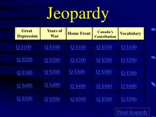
Intro to Social Studies. JEOPARDY. Contestants. Don’t Forget. …Always phrase your answers in the form of a question!. Hands on your buzzers, its. Intro to Social Studies. JEOPARDY!. PIRIACCH. Latitude & Longitude. Climate & Weather. Potpourri (Anything). The Social Studies.

E N D
Intro to Social Studies JEOPARDY
Contestants Don’t Forget...
Hands on your buzzers, its... Intro to Social Studies JEOPARDY!
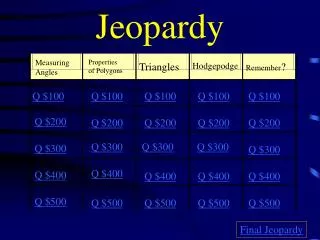
PIRIACCH Latitude & Longitude Climate & Weather Potpourri (Anything) The Social Studies Globes & Maps CLICK HERE FOR FINAL JEOPARDY 100 100 100 100 100 100 200 200 200 200 200 200 300 300 300 300 300 300 400 400 400 400 400 400 500 500 500 500 500 500
The Social Studies $100 THE STUDY OF PAST EVENTS, PEOPLE, OR TIME PERIODS.
History Back toGame
The Social Studies $200 THE STUDY OF THE EARTH'S SURFACE, CLIMATES, AND ITS EFFECTS ON HUMAN CULTURES.
Geography Back toGame
The Social Studies $300 THE SCIENCE OF MONEY, GOODS, AND SERVICES
Economics Back toGame
The Social Studies $400 THE SCIENCE OF GOVERNMENT AND HOW IT WORKS.
Politics Back toGame
The Social Studies $500 THE STUDY OF SOCIETY AND SOCIAL BEHAVIOR.
Sociology Back toGame
Globes & Maps $100 GLOBES ARE ACCURATE BECAUSE THEY ARE THIS SHAPE.
A Sphere Back toGame
Globes & Maps $200 THIS IS ONE DISADVANTAGE OF A GLOBE.
Hard to carry around, less detailed, or only one side can be viewed at a time Back toGame
Globes & Maps $300 THIS IS ONE ADVANTAGE OF A MAP.
Can be carried easily, can be more detailed, can see whole Earth at once Back toGame
Globes & Maps $400 THIS MAP PROJECTION SHOWS FAIRLY ACCURATE SIZE AND SHAPE WITH SOME DISTORTION NEAR THE EDGES.
Robinson Projection Back toGame
Globes & Maps $500 THIS MAP PROJECTION SHOWS TRUE SHAPE BUT DISTORTS SIZE.
Mercator Projection Back toGame
Latitude & Longitude $100 THESE LINES RUN EAST AND WEST AND HELP MEASURE NORTH AND SOUTH.
Lines of Latitude Back toGame
DAILY DOUBLE DAILY DOUBLE DAILY DOUBLE DAILY DOUBLE
Latitude & Longitude $200 DAILY DOUBLE WHEN WRITING LATITUDE AND LONGITUDE, THIS ONE IS WRITTEN FIRST.
Latitude Back toGame
Latitude & Longitude $300 THESE LINES RUN FROM THE NORTH POLE TO THE SOUTH POLE AND MEASURE EAST AND WEST.
Lines of Longitude Back toGame
Latitude & Longitude $400 THIS IS ZERO DEGREES LONGITUDE.
The Prime Meridian Back toGame
Latitude & Longitude $500 EVERY LOCATION IN THE UNITED STATES WILL BE IN THESE TWO HEMISPHERES.
The Northern Hemisphere and the Western Hemisphere Back toGame
Physical Regions (PIRIACCH) $100 THESE ISLANDS IN THE PACIFIC WERE FORMED BY VOLCANIC ACTIVITY.
Hawaiian Islands Back toGame
Physical Regions (PIRIACCH) $200 THIS REGION IS KNOWN AS THE BREADBASKET OF THE WORLD BECAUSE IT PRODUCES A LOT OF WHEAT AND CORN.
The Interior Plains Back toGame
Physical Regions (PIRIACCH) $300 THIS REGION INCLUDES THE TALLEST MOUNTAINS IN NORTH AMERICA AND RUNS FROM ALASKA, THROUGH THE US, AND THROUGH MEXICO.
The Rocky Mountains Back toGame
Physical Regions (PIRIACCH) $400 THIS REGION OF LOWER, LESS RUGGED MOUNTAINS RUNS FROM GEORGIA TO MAINE AND WAS THE WESTERN BORDER OF THE 13 COLONIES.
The Appalachian Mountains Back toGame
Physical Regions (PIRIACCH) $500 THIS DRY, RUGGED REGION CONTAINS MANY CANYONS AND PLATEAUS.
The Intermountain Region Back toGame
Climate & Weather $100 ONE FACTOR THAT AFFECTS CLIMATE IS THIS, WHICH MEANS HOW FAR YOU ARE FROM THE EQUATOR.
Latitude Back toGame
Climate & Weather $200 THIS IS THE DIFFERENCE BETWEEN WEATHER AND CLIMATE.
Weather changes day to day, but climate generally stays the same Back toGame