Download
1 / 1
10 likes | 179 Views
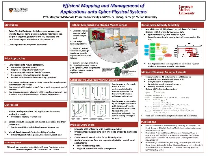
0101010010. 0101010010101010. Efficient Mapping and Management of Applications onto Cyber -Physical Systems. Prof. Margaret Martonosi, Princeton University and Prof. Pei Zhang, Carnegie Mellon University. Testbed : Minimalistic Controlled Mobile Sensor. Motivation. Project Future Work.

E N D
0101010010 0101010010101010 Efficient Mapping and Management of Applications onto Cyber-Physical Systems Prof. Margaret Martonosi, Princeton University and Prof. Pei Zhang, Carnegie Mellon University Testbed: Minimalistic Controlled Mobile Sensor Motivation Project Future Work Prior Approaches Mobile Offloading: An Initial Example Publications Our Project Region-Scale Mobility Modeling Acknowledgments Collaborative Coverage Without Location • Select when to use 3G and when to use WiFi based on: • Availability and bandwidth of 3G and WiFi • Delay tolerance of application • Cost of data transfers on each network • Mobility prediction of device • Optimal MILP Scheduler Formulation • 8-10X cost reduction due to optimization and delay tolerance • Model Human Mobility based on cellphone Call Detail Records (CDRs) or similar aggregate info: • Sparse in time: Only when phone call in/out • Coarse in space: Only to granularity of cell tower spacing. (Not GPS) • Our Approach offers accuracy sufficient for detailed regional studies of human and vehicular movements. • Simplifications to reduce complexity. • Assume homogeneous systems • Program for one particular deployment • Current approach leads to “brittle” systems. • Deployments with multi-generation devices • Multiple scenarios with different mobility capabilities • How to meet performance and accuracy goals while managing power and other scarce resources? • How to select which devices to use? From a static or dynamic pool of resources. • How to support dynamic adaptivity within a single deployment? How to support portable operation across different deployments? • Cyber-Physical Systems: richly heterogeneous devices (mobile devices, home electronics, taxis, robotic drones, etc.) that together gather sensor data, analyze it, and coordinate large-scale actions in response to it. • Challenge: How to program CP Systems? • Abstraction layer to allow CPS applications to express application needs • Coverage and sensing requirements • Device attribute catalog to summarize local nodes and their capabilities • Sensing capabilities, probability of success, accuracy, etc. • Model, Prediction and Control mobility of nodes • Different types of motion (people, fixed sensors, robot, etc.) This work was supported by the National Science Foundation under collaborative grants CPS-1135874 and CPS-1135953. • Integrate WiFi offloading with mobility prediction • Broaden mapping problems from two-node offload to multi-node offload • Explore use of virtualization for mobile migration • Apply programming flow and dynamic adaptation to real-word applications: • First responder support • Regional automotive traffic management • Sibren Isaacman et al. Human Mobility Modeling via Synthetic Call Detail Records." 10th Intl. Conf. on Mobile System, Applications, and Services (MobiSys 2012) • Ozlem Bilgir Yetim and Margaret Martonosi. "Adaptive Usage of Cellular and WiFi Bandwidth: An Optimal Scheduling Formulation (Short Paper).” 7th ACM Intl. Workshop on Challenged Networks (CHANTS 2012) • Frank Mokaya, Aveek Purohit, Pei Zhang, “Invited Paper: SensorFly: Flying Sensor Network for Indoor Situational Awareness in a Disaster”, The Wireless Personal Multimedia Communications Symposium (WPMC’12) Sep. 2012 • Unreliable nodes: expected to fail, can crash or get stuck • Low weight, • Low-cost prototype • Adapt to changing • environment, reassign • task based on node • capabilities and localized • failures • Dynamic coverage estimation: • by obtaining in-network relative • path signatures, then assign task to • multiple nodes to compute • signature paths PLUGIN SENSOR MODULE: 3-Axis Accelerometer 3-Axis Gyroscope 3-Axis Magnetometer MAIN BOARD: 16 MHz AVR AtMega128RFA1 16Kb SRAM 128Kb Flash Memory 2.4GHz 802.15.4 Radio • Sensing coverage for mobile nodes in many environments is hard to determine due to lack of known infrastructure or references for locations. • Sensing coverage estimation by obtaining relative motion path signatures. Dynamic task allocation allow nodes to more efficiently coordinate and predict the current sensing coverage of an area.