Download
1 / 24
240 likes | 398 Views
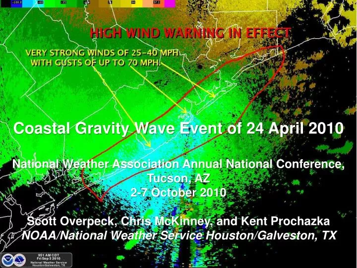
Coastal Gravity Wave Event of 24 April 2010 National Weather Association Annual National Conference, Tucson, AZ 2-7 October 2010 Scott Overpeck , Chris McKinney, and Kent Prochazka NOAA/National Weather Service Houston/Galveston, TX.

E N D
Coastal Gravity Wave Event of 24 April 2010National Weather Association Annual National Conference, Tucson, AZ2-7 October 2010Scott Overpeck, Chris McKinney, and Kent ProchazkaNOAA/National Weather Service Houston/Galveston, TX
The goal of this study is to document the passing of mesoscale gravity waves that propagated along the Upper Texas Coast during the early morning hours of 24 April 2010. Pressure changes of 5-7 hPa were observed with the passing of the waves, and high winds of 60 knots caused damage to house roofs and snapped power poles. • Synoptic Environment for Gravity Waves. • Possible source region of the Gravity Waves on April 24. • IR and Water Vapor Satellite Imagery, Radar reflectivity and base velocity showing the Gravity Wave passage. • Corresponding pressure and wind data from 5 observation sites along the Upper Texas Coast. • Summary of the event. Overview
Gravity Wave Summary • The gravity wave most likely had a period of about 3 hours, a wavelength between 155-215 NM, and a velocity of 52-65 knots. • The average pressure change was 6.7 hPa with a minimum pressure of 995.6 hPa and wind speeds of 37 knots (gusts of 47 knots).
Questions? Comments?Coastal Gravity Wave Event of 24 April 2010National Weather Association Annual National Conference, Tucson, AZ2-7 October 2010Scott Overpeck, Chris McKinney, and Kent ProchazkaNOAA/National Weather Service Houston/Galveston, TXE-mail: scott.overpeck@noaa.gov