Download
1 / 24
300 likes | 747 Views
OGC Web Services. Kai Lin San Diego Supercomputer Center klin@sdsc.edu. OGC Web Services. OGC Specifications Based on HTTP Protocol (GET/ POST) XML as standard encoding (W3C) Related to geospatial information Some of main OGC services: Web Map Service (WMS) Web Feature Service (WFS)

E N D
OGC Web Services Kai Lin San Diego Supercomputer Center klin@sdsc.edu
OGC Web Services • OGC Specifications • Based on HTTP Protocol (GET/ POST) • XML as standard encoding (W3C) • Related to geospatial information • Some of main OGC services: • Web Map Service (WMS) • Web Feature Service (WFS) • Web Coverage Service (WCS) • Catalogue Service for the Web (CSW) • Not SOAP. REST?
Web Map Service (WMS) • Requests for images of map data • Point based query functionality • Main operations: • GetCapabilities: • Metadata about the types/operations the WMS supports • GetMap • Map of the requested data • GetFeatureInfo • Feature information about a particular point within a map • Open source implementations • UMN Map Server • GeoServer
Web Feature Service (WFS) • Requests for spatial features • Return vector data (in GML) • Rich query interface • Main operations: • GetCapabilities: • Metadata about the types/operations the WFS supports • DescribeFeatureType • A list of features and associated attributes • GetFeature • Features by spatial querying and filtering • Open source implementations • GeoServer • Deegree
Web Coverage Service (WCS) • Requests for raw (typically gridded) data • Return in well known binary formats • Main operations: • GetCapabilities: • Metadata about the types/operations the WCS supports • DescribeCoverage • Structural information about one or more coverages • GetCoverage • Coverage data by spatial querying and filtering • Open source implementations • GeoServer • Deegree
Catalogue Service for the Web (CSW) • Standard API for manipulating metadata records • creating, updating, deleting for resource providers • querying metadata records for resource users • Profiles (Information Model) • FGDC • ISO19119 / ISO19115 • OASIS eBussiness Registry Information Model (ebRIM, preferred) • Request formats: XML or name-value pairs • Query language • Filter Encoding Specification (used in WFS) • Common Query Language (CQL) • Others defined in profiles • Response in XML • Open source implementations: GeoNetwork, Deegree
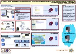
Catalog Service Catalog A Typical CSW Use Case Client Description (Metadata) Resource
CSW Operations • GetCapabilities: • Metadata about the types/operations the CSW supports • DescribeRecord: • Schema description of the CSW Information Model • GetDomain: • Runtime value space for parameters used in API • GetRecords: • Metadata records with possibility of filtering (spatial, temporal, keywords conditions, etc.) • GetRecordByID • Metadata records with the specified ID • Transaction • Create, update and delete metadata records • Harvest • Retrieve metadata from other catalogue services • Supporting periodic retrieving
What You Can Query • Core Queryables • Subject: the topic of the resource • Title: the name of the resource • Abstract: a summary of the resource • AnyText: for full text search • Format: physical manifestation • Identifier: unique reference to the resource • Modified: data the resource created or updated • Type: genre of the resource • BoundingBox: a bounding box for interested area • CRS: coordinate system • Association: relation with other resources
What CSW Response for a Query • Response Returnables • Title: correspondent to the query attribute Title • Creator • Subject: correspondent to the query attribute Subject • Description : correspondent to the query attribute Abstract • Publisher • Contributor • Date : correspondent to the query attribute Modified • Type : correspondent to the query attribute Type • Format : correspondent to the query attribute Format • Identifier : correspondent to the query attribute Identifier • Language • Relation : correspondent to the query attribute Association • Coverage : correspondent to the query attribute BoundingBox • Rights
CSW Response Levels Full Level Creator Publisher Contributor Language Rights Summary Level Subject Format Description Date Coverage Relation Brief Level Identifier Title Type
Example Request of CSW GetRecords <?xml version="1.0" encoding="UTF-8"?> <GetRecords service="CSW" version="2.0.2" maxRecords="1000" outputSchema="http://www.opengis.net/cat/csw/2.0.2" outputFormat="application/xml"> <Query typeNames=”csw:Record”> <ElementSetName>brief</ElementSetName> <Constraint version="1.2.0”> <ogc:Filter> <ogc:And> <ogc:PropertyIsLike escape="" singleChar="_" wildCard="%"> <ogc:PropertyName>/Record/AnyText</ogc:PropertyName> <ogc:Literal>%Your-Search-Term%</ogc:Literal> </ogc:PropertyIsLike> <ogc:T_During> <ogc:PropertyName>/Record/dct:modified</ogc:PropertyName> <gml:TimePeriod> <gml:begin>2007-01-01</gml:begin> <gml:end>2007-12-31</gml:end> <gml:TimePeriod> </ogc:T_During> <ogc:Or> <ogc:PropertyIsEqualTo> <ogc:PropertyName>/Record/dc:type</ogc:PropertyName> <ogc:Literal>urn::csw-ObjectType:FeatureType</ogc:Literal> </ogc:PropertyIsEqualTo>
Example Request of CSW GetRecords (cont.) <ogc:PropertyIsEqualTo> <ogc:PropertyName>/Record/dc:Type</ogc:PropertyName> <ogc:Literal>urn:csw-ObjectType:WMS_Layer</ogc:Literal> </ogc:PropertyIsEqualTo> </ogc:Or> <ogc:classifiedAs scope="broad"> <ogc:TypeName>Record</ogc:TypeName> <ogc:Scheme>urn:gcmd</ogc:Scheme> <ogc:Node>urn:gcmd:oceans:seafloor:topography</ogc:Node> </ogc:classifiedAs> <ogc:Contains> <ogc:PropertyName>/Record/ows:BoundingBox</ogc:PropertyName> <gml:Envelope srsName="EPSG:4326"> <gml:lowerCorner>-80,30</gml:lowerCorner> <gml:upperCorner>-70,40</gml:upperCorner> </gml:Envelope> </ogc:Contains> </ogc:And> </ogc:Filter> </Constraint> </Query> </GetRecords>
Response of CSW GetRecordById <?xml version="1.0" encoding="ISO-8859-1"?> <Record xmlns="http://www.opengis.net/cat/csw/2.0.2" xmlns:dc="http://purl.org/dc/elements/1.1/" xmlns:dct="http://purl.org/dc/terms/" xmlns:ows="http://www.opengis.net/ows" xmlns:xsi="http://www.w3.org/2001/XMLSchema-instance" xsi:schemaLocation="http://www.opengis.net/cat/csw/2.0.2 ../../../csw/2.0.2/record.xsd"> <dc:identifier>00180e67-b7cf-40a3-861d-b3a09337b195</dc:identifier> <dc:title>Image2000 Product 1 (at1) Multispectral</dc:title> <dct:modified>2004-10-04 00:00:00</dct:modified> <dct:abstract>IMAGE2000 product 1 individual orthorectified scenes. IMAGE2000 was produced from ETM+ Landsat 7 satellite data and provides a consistent European coverage of individual orthorectified scenes in national map projection systems.</dct:abstract> (to be continued)
Response of CSW GetRecordById (Cont.) <dc:type>dataset</dc:type> <dc:subject>imagery</dc:subject> <dc:subject>baseMaps</dc:subject> <dc:subject>earthCover</dc:subject> <dc:format>BIL</dc:format> <dc:creator>Vanda Lima</dc:creator> <dc:language>en</dc:language> <ows:WGS84BoundingBox> <ows:LowerCorner>14.05 46.46</ows:LowerCorner> <ows:UpperCorner>17.24 48.42</ows:UpperCorner> </ows:WGS84BoundingBox> </Record>
ebRIM • Provides a metamodel for describing metadata • Expressed in XML • Manage associations among many aspects: • Dataset descriptions • Service interface descriptions • Coordinate reference systems • Units of Measure • Application schemas, feature types • Map styles and symbol libraries • Access control policies • Sensor description • Ontological descriptions • Digital rights • Organizations and Projects
More Queryables by ebRIM • Queryables • Time period of data validity • Time period of collection • Phenomenon represented • Geographic Extent • Topic categories / ISO terms • Creator • Organization • Scale / resolution • Metalevel • Classification • Processed state • …………
WFS GetCapabilities <?xml version="1.0" ?> <GetCapabilities service="WFS” version="1.0.0" xmlns="http://www.opengis.net/wfs" /> <WFS_Capabilities xmlns="http://www.opengis.net/wfs" version="1.0.0" xmlns:ogc="http://www.opengis.net/ogc" xmlns:myns="http://www.example.com/myns"> <Service> <Name> Oracle WFS </Name> <Title> Oracle Web Feature Service </Title> <Abstract> Web Feature Service maintained by Oracle </Abstract> <OnlineResource>http://localhost:8888/wfsservlet</OnlineResource> </Service> <Capability> <Request> <GetCapabilities> ………. </GetCapabilities> ……….
WFS GetCapabilities (Cont.) <FeatureTypeList> <Operations> <Insert/> <Update/> <Delete/> <Query/> <Lock/> </Operations> <FeatureType xmlns:myns="http://www.example.com/myns"> <Name> myns:COLA</Name> <Title> LIST OF COLA MARKETS </Title> <SRS> SDO:8307</SRS> </FeatureType> ………… </FeatureTypeList> ………… </WFS_Capabilities>
WFS DescribeFeatureType <?xml version="1.0" ?> <wfs:DescribeFeatureType service="WFS” version="1.0.0" xmlns:wfs="http://www.opengis.net/wfs" xmlns:myns="http://www.example.com/myns" xmlns:xsi="http://www.w3.org/2001/XMLSchema-instance" xmlns:xsd="http://www.w3.org/2001/XMLSchema" xsi:schemaLocation="http://www.opengis.net/wfs ../wfs/1.0.0/WFS-basic.xsd"> <wfs:TypeName>myns:COLA</wfs:TypeName> </wfs:DescribeFeatureType> <xsd:schema targetNamespace="http://www.example.com/myns" xmlns:wfs="http://www.opengis.net/wfs" xmlns:myns="http://www.example.com/myns" xmlns:gml="http://www.opengis.net/gml" elementFormDefault="qualified" version="1.0.0" xmlns:xsd="http://www.w3.org/2001/XMLSchema"> <xsd:import namespace="http://www.opengis.net/gml" schemaLocation="http://localhost:8888/examples/servlets/xsds/feature.xsd"/> <xsd:element name="COLA" type="myns:COLAType" substitutionGroup="gml:_Feature"/>
WFS DescribeFeatureType (Cont.) <xsd:complexType name="COLAType"> <xsd:complexContent> <xsd:extension base="gml:AbstractFeatureType"> <xsd:sequence> <xsd:element name="MKT_ID" type="xsd:double"/> <xsd:element name="NAME" nillable="true"> <xsd:simpleType> <xsd:restriction base="xsd:string"> <xsd:maxLength value="32"/> </xsd:restriction> </xsd:simpleType> </xsd:element> <xsd:element name="SHAPE" type="gml:PolygonMemberType" nillable="true"/> </xsd:sequence> <xsd:attribute name="fid" type="xsd:double"/> </xsd:extension> </xsd:complexContent> </xsd:complexType> </xsd:schema>
WFS GetFeature Request <?xml version="1.0" ?> <wfs:GetFeature service="WFS version="1.0.0” xmlns:wfs="http://www.opengis.net/wfs xmlns:ogc=http://www.opengis.net/ogc xmlns:myns=http://www.example.com/myns xmlns:xsi=http://www.w3.org/2001/XMLSchema-instance xsi:schemaLocation="http://www.opengis.net/wfs ../wfs/1.0.0/WFS-basic.xsd"> <wfs:Query typeName="myns:COLA"> <ogc:PropertyName>myns:MKT_ID</ogc:PropertyName> <ogc:PropertyName>myns:NAME</ogc:PropertyName> <ogc:PropertyName>myns:SHAPE</ogc:PropertyName> <ogc:Filter> <ogc:And> <ogc:And> <ogc:PropertyIsGreaterThan> <ogc:PropertyName>myns:COLA/myns:MKT_ID</ogc:PropertyName><ogc:Literal> 2 </ogc:Literal> </ogc:PropertyIsGreaterThan> <ogc:PropertyIsEqualTo> <ogc:PropertyName>myns:COLA/myns:NAME</ogc:PropertyName><ogc:Literal>cola_c</ogc:Literal> </ogc:PropertyIsEqualTo> </ogc:And> <ogc:Or> <ogc:PropertyIsEqualTo> <ogc:PropertyName>myns:COLA/myns:MKT_ID</ogc:PropertyName><ogc:Literal>3</ogc:Literal> </ogc:PropertyIsEqualTo> <ogc:PropertyIsEqualTo> <ogc:PropertyName>myns:COLA/myns:NAME</ogc:PropertyName><ogc:Literal>cola_d</ogc:Literal> </ogc:PropertyIsEqualTo> </ogc:Or> </ogc:And> </ogc:Filter> </wfs:Query> </wfs:GetFeature>
WFS GetFeature Response <?xml version = '1.0' encoding = 'UTF-8'?> <wfs:FeatureCollection xsi:schemaLocation="http://www.example.com/myns http://localhost:8888/wfsservlet?featureTypeId=1 http://www.opengis.net/wfs ../wfs/1.0.0/WFS-basic.xsd" xmlns:wfs="http://www.opengis.net/wfs" xmlns:xsi="http://www.w3.org/2001/XMLSchema-instance"> <gml:boundedBy xmlns:gml="http://www.opengis.net/gml"> <gml:Box srsName="SDO:8307"> <gml:coordinates>3.0,3.0 6.0,5.0</gml:coordinates> </gml:Box> </gml:boundedBy> <gml:featureMember xmlns:gml="http://www.opengis.net/gml"> <myns:COLA fid="3" xmlns:myns="http://www.example.com/myns"> <myns:MKT_ID>3</myns:MKT_ID> <myns:NAME>cola_c</myns:NAME> <myns:SHAPE> <gml:Polygon srsName="SDO:8307" xmlns:gml="http://www.opengis.net/gml"> <gml:outerBoundaryIs> <gml:LinearRing> <gml:coordinates decimal="." cs="," ts=" ">3.0,3.0 6.0,3.0 6.0,5.0 4.0,5.0 3.0,3.0 </gml:coordinates> </gml:LinearRing> </gml:outerBoundaryIs> </gml:Polygon> </myns:SHAPE> </myns:COLA> </gml:featureMember> </wfs:FeatureCollection>