Download
1 / 8
90 likes | 225 Views
Zahid Chaudhry ITO-TAGIS West Virginia Department of Environmental Protection. Digital Assets Management System (DAM). http://zachsgeospatial.blogspot.com/. DAM. Digital Photos with GPS Info Ricoh 500 Ses Nikon COOLPIX - P 6000 Cell Phone with GPS

E N D
Zahid Chaudhry ITO-TAGIS West Virginia Department of Environmental Protection Digital Assets Management System (DAM) http://zachsgeospatial.blogspot.com/
DAM • Digital Photos with GPS Info • Ricoh 500 Ses • Nikon COOLPIX - P 6000 • Cell Phone with GPS • Integration with ArcGIS Server Workflow • PHP, Python, Adobe FLEX • Better decision support system
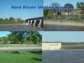
Queries? • DMR SMCRA permit number where EVERY photo is taken. • OOG API number nearest photo • DWW WAP number • OAML&R PAD number EXAMPLES: Find all the photos taken on SMCRA permit number XXXXXXX Find photos take within 5 miles of API number YYYYYYYY
Current Design • Upload multiple photos straight from camera at the same time • Automatically strip out EXIF header info • Get coordinates • Get compass data for photo orientation • Get GPS fix quality data PDOP • Create an ArcSDE point layer on-the-fly • Allow user to select keywords to merge with point data attributes and write to the application’s Oracle tables