Download
1 / 82
830 likes | 1.08k Views
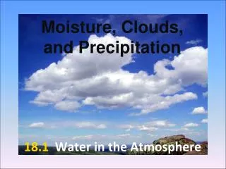
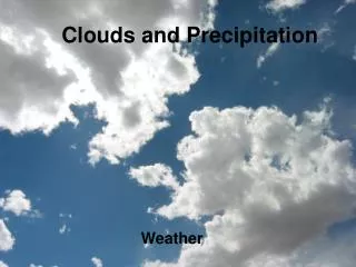
Moisture, Clouds, and Precipitation. Humidity. Describes the amount of water vapor in the air Relative humidity – ratio of actual water vapor content compared to the amount of water vapor that the air can hold at a particular temperature and pressure Can be changed by:

E N D
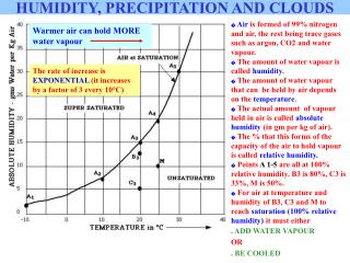
Humidity • Describes the amount of water vapor in the air • Relative humidity – ratio of actual water vapor content compared to the amount of water vapor that the air can hold at a particular temperature and pressure • Can be changed by: • Adding or taking water vapor away • Temperature – higher temperatures can hold more water
Atmosphere Terms • Dew point – temperature air should be cooled to in order for water vapor to condense
Cloud Formation • In order for clouds to form, air has to rise. It will rise to meet air of the same temperature (stability)
Water vapor rises until it finds stable air, then it converts to liquid around a condensation nucleito form a cloud • Dust, smoke, or salt or something for the water to attach and form a droplet
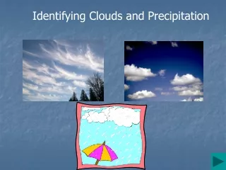
18.3 – Cloud types and precipitation • Clouds are classified on the basis of form and height • 4 types
Bergeron Process (Cold cloud precipitation) • Supercooling: • Water in the upper atmosphere turns solid at ------- 40ºC, not 0ºC • When supercooled water falls from the sky and hits the ground, it freezes on impact = freezing rain • Supersaturation: • When air is saturated, the water vapor cannot coexist with ice crystals, so the water vapor freezes and falls as snow flakes
Warm cloud precipitation • Collision-coalescence process • As cloud droplets move through the cloud, more water collects and the drops grow • When the drops get too large, they fall as rain
Forms of precipitation • Sleet, glaze, and hail: • Sleet – small particles of ice • Glaze - freezing rain • Hail – supercooled water droplet that falls through a cumulonimbus cloud, gaining water and freezes by the time it leaves the cloud
Atmospheric Conditions • Weather – state of atmosphere at any point in time • Both are driven by the Sun
Air Pressure • Weight of the air above • Exerted in all directions, so objects do not collapse from the weight • Measured with barometer • Caused by uneven heating of Earth’s surface
Isobars - Lines that connect equal points of air pressure • Difference shows how rapidly or slowly pressure is changing –pressure gradient
Called anticyclones Rotate clockwise Highest pressure in center Tend to have calm, clear weather Winds flow outward away from center Called cyclones Rotate counterclockwise Lowest pressure at center Associated with bad weather Winds flow inward towards the center High Low
Wind • Caused by the uneven heating of Earth’s surface, resulting in horizontal differences in air pressure • Flows from high to low • Wind name = the direction it blows from • 3 factors control wind: • Pressure difference (creates wind) • Coriolis Effect (gives direction) • Friction (speed)
Global Winds • Warm air moves towards high latitudes (rises) while cool air travels towards the equator (sinks) creating a convection cell
Earth’s Wind Systems • 0-30° N/S - Trade winds (east to west) • 30-60° N/S – Prevailing Westerlies (west to east) • 60-90° N/S – Polar easterlies (east to west) • Jet stream – high altitude belt of wind that travels west to east above the friction zone • Airplanes use this to travel places faster
Measuring Wind • A wind vane measures direction • An anemometer measures wind speed
Air Masses • Immense body of air with similar temperatures and moisture at any altitude • Air masses move and they take on the characteristics of the new area they cover (air mass modification)
Classifying air masses • Named for source region • Characteristics: • m (maritime) - form over water (humid) • c (continental) – form over land (dry) • T (tropical) – form at low latitudes (hot) • P (polar) – form at high latitudes (cold)
4 types of air masses: • 1. continental polar (cP) • dry and cool • Canada and over Great Lakes • 2. continental tropical (cT) • dry and warm/hot • Southwest U.S.
More on air masses • 3. maritime polar (mP) • humid and cold • northern Pacific • 4. maritime tropical (mT) • humid and hot • Gulf of Mexico or Southern Pacific
Fronts • The boundary between two air masses • 4 types – each with specific symbol • Front is moving the direction the symbol is pointing
Warm Fronts • Definition: warm air moves into an area that was covered by cold air • Symbol: red line with red semicircles • Weather associated with front: • Warmer temperatures • Light-to-moderate precipitation
Cold Fronts • Definition: cold air moves into an area that had warmer air (forces it upward) • Symbol: blue line with blue triangles, • Weather Associated: • Heavy downpours • Gusty winds
Stationary Fronts • Definition: cold air mass and warm air mass meet and the masses travel parallel to the line • Symbol: blue triangles on one side, red semicircles on the other side • Weather Associated: • Gentle to moderate precipitation
Occluded Fronts • Definition: active cold front overtakes an active warm front • Symbol: purple triangles and purple semicircles on the same side • Weather Associated: • Light precipitation
Weather Instruments Hygrometer –humidity Ceilometer – cloud height
Doppler Radar • Doppler Effect –wave frequency changes as energy is moved towards or away from a point • Predicts wind speeds
Doppler Weather Radar • Locates storms (waves are scattered by raindrops) • Tracks precipitation, not clouds • Can also measure wind speeds due to rain scattering the signal
Weather Satellites • Tracks clouds, not precipitation
Forecasting SHORT TERM LONG TERM Up to 10 days Less accurate - too many atmospheric variables • Up to 3 days • More accurate
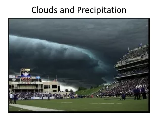
Severe Weather – Thunderstorms, Tornadoes, and Hurricanes • Thunderstorm - storm that generates lightning and thunder • Produce gusty winds, heavy rain, and hail • Form when warm, humid air rises in an unstable environment and form a cumulonimbus cloud
Air Movement within the Cloud – Key to formation • Updrafts – strong upward movement of air (cause storm cloud to grow) • Downdraft – strong downward movement of air (cool the cloud)
3 stages of development: • 1. Cumulus: strong updrafts cause warm air to rise, making the cloud grow taller
2. Mature: • Equal updrafts and downdrafts make a convection cell • Rain starts = cloud growth stops
3. Dissipation: • Warm air runs out • Precipitation no longer forms • Downdrafts cause the storm to fall apart
Lightning • Circulating ice particles in a cumulonimbus cloud create areas of opposite charge within the cloud • Positive at the top; negative at the bottom • To relieve the imbalance, ions travel to the ground to even out
Parts of Lightning 1. Stepped leader- invisible channel of ions that travels from the cloud to the ground 2. Return stroke- the visible channel that rushes up to meet the stepped leader
Thunder • Gas around electron stream is superheated causing rapid expansion and contraction and makes a cracking sound