Download
1 / 1
10 likes | 125 Views
THE CURRENT STATE OF VOLCANIC RISK AND CRISIS MANAGEMENT AT VOLCAN DE FUEGO, GUATEMALA: FORMAL RISK VERSUS PERCEIVED RISK ASSESSMENTS. Rüdiger Packal Escobar Wolf (rpescoba@mtu.edu)

E N D
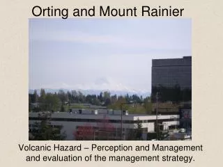
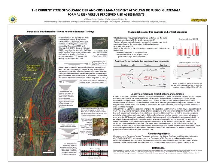
THE CURRENT STATE OF VOLCANIC RISK AND CRISIS MANAGEMENT AT VOLCAN DE FUEGO, GUATEMALA: FORMAL RISK VERSUS PERCEIVED RISK ASSESSMENTS. Rüdiger Packal Escobar Wolf (rpescoba@mtu.edu) Department of Geological and Mining Engineering and Sciences. Michigan Technological University. 1400 Townsend Drive, Houghton, MI 49931 Pyroclastic flow hazard for Towns near the Barranco Taniluya Probabilistic event tree analysis and critical scenarios Eruptions VEI since 1500 AD Pyroclastic flows are arguably the most severe hazard related to the current activity of Volcán de Fuego. Areas that could be affected by this hazard were mapped by Rose et al. (1988) and Vallance et al. (2001). Bonis and Salazar (1971) recognized the possibility that flows could “overflow” the channel and inundate the interfluvial terrain during large to moderate eruptions (VEI 3 to 4), and destroy the nearby communities. • What is the most relevant set of scenarios and what are the main variables associated with the crisis management? • Perform a formal probabilistic event tree analysis considering a set of scenarios defined by the combination of different variables. • (e. g. VEI, volume, etc…) • Analyze the behavior of the activity during previous eruptions to infer the likelihood of: • - Possible precursors to a large eruption. • - Time from the start of the eruption to the • generation of large pyroclastic flows. 1 Km 4 3 VEI 2 1 Data from the Global Volcanis Program: http://www.volcano.si.edu/world/volcano.cfm?vnum=1402-09=&volpage=erupt Pyroclastic flow that filled and over spilled the Sta Teresa channel in June 2003. 1500 1600 1700 1800 1800 2000 Year Moderate eruptions since 2002 Event tree for a pyroclastic flow event reaching a community Cross section of the Taniluya channel at ca. 2500 masl. 100 m Eruption VEI Volume Overflow Pyroclastic flows ACS’s from 2002 to 2007 Dense basal avalanches and ash cloud surges (ACS’s) have been common during Fuego’s historic activity, including the current eruptive activity episode (1999 to the present). Barranca Taniluya is one of the main active drainages that routes Fuego’s pyroclastic flows. The communities of Panimache I and Morelia are located in the interfluvial terrain immediately west of Taniluya. Yes 2… <107 m3 15 No Data compiled from various sources (INSIVUMEH bulletins, OVFUGO/INSIVUMEH records, GOES and MODIS/MODVOLC thermal satellite data, RSAM values (INSIVUMEH), Secretaria Ejecutiva de CONRED crisis bulletins, Otoniel Matías, John Lyons and Jemile Erdem personal communication (2007 & 2008) and personal notes. Cumulative number of eruptions 10 Yes 3… 5 Year Yes 2002 2008 >107 m3 & <4x10⁷ m3 ACS’s from 2002 to 2007 4 No Cross section of the Taniluya channel at ca. 1800 masl. Notice the increase in depth. 100 m 5… Yes Fuego erupted more than 60 eruptions in the last 500 years (7 with VEI = 4) and 18 moderate eruptions between 2002 and 2008 (VEI = 2). >4x10⁷ m3 No No Cross section of the Taniluya channel at ca. 1200 masl. Depth and cross sectional area are near a maximum. Local vs. official and expert beliefs and opinions A series of semi-structured interviews and focus group discussions (35) with the potential stakeholders (49 people) that would participate in the management of a volcanic crisis was performed, considering four target groups considered: Local population, local authorities, Civil Defense (CONRED), and volcanologists that had some experience with the volcano. The interview was structured in 3 blocks: general knowledge of the volcanic risk and risk perception, beliefs about what is likely to be expected during a future crisis, and their opinions on how such a crisis should be managed. Although there is a general expectation among all the groups that an early warning system may be a possible (and maybe the only) way to manage the crisis, different groups have different degrees of optimism about how like it is that such a system will actually work. Most of those interviewed think that Fuego is likely to produce a large and potentially catastrophic eruption during their lifetimes. Local people who had previous experiences with volcanic crisis (e. g. the 1974 eruption) usually acknowledge that the main risk to their lives is the one associated with the pyroclastic flows over-spilling the channel margins, whereas other people may not recognize this as the main hazard. Interviewed indivicuals from all the groups expressed that the decision to evacuate will be strongly dependent on the availability of real-time information about the development of the crisis (hazard) and on the availability of resources to mobilize the population, provide shelter, and provide security to their belongings. There is a wide range of views about who decides on the evacuation of the communities, as well as to who should provide resources to undertake such a massive task. Digital cartography: High resolution (50 cm pixel) orthophotos aquired between Nove. 2005 and Apr. 2006 by the Instituto Geografico Nacional (Guatemala). Orthophotos: 2059-III-3, 2059-III-7, 2059-III-8, 2059-III-11, and 2059-III-12. Digital elevation data used to derive the channel cross sections: DEM (10 m pixel) derived from elevation contours (20 m interval) from the Alotenango Topographic Map Quadrangle (2059-III). Digitized and interpolated to a DEM by the USGS. Typical pyroclastic flow deposit from the 70’s eruptions on Barranca Taniluya. Typical pyroclastic cross section of Barranca Taniluya at ca. 1200 masl. Note the very steep channel walls and the recent pyroclastic flow deposit (2002 - 2007) on the lower left corner. Panimache I Pyroclastic flows hazard zone by Vallance et al (2001) Apparently young pyroclastic flow deposits underlying Panimache I. Note the fine grain size of the deposit, possibly indicating an overbank flow event. Cross sectional area decreases downstreams. Pyroclastic flows from the 70’s 100 m Acknowledgements Morelia Fieldwork on the “Barrancas” around Fuego was assisted by the Amilcar Cardenas and Edgar Barrios from the OVFUEGO-INSIVUMEH volcanic observatory at Panimache. Eddy Sanchez and Gustavo Chinga from INSIVUMEH kindly allowed me to use the observatory’s facilities. Otoniel Matias and Juan Boc helped with the fieldwork. Jemile Erdem helped with interviews. This study is funded by NSF through grant OISE 0530109. Cross section area (m2) 10,000 The area where the pyroclastic flows are deposited is related to the slope and morphology of the channel. Distinctive lithofacies associations have been recognized. 0 References Thalweg depth (m) 100 1 Km • Bonis S, Salazar O, 1973. The 1971 and 1973 eruptions of volcano Fuego, Guatemala, and some socio-economic considerations for the volcanologist. Bull Volc, 37: 394-400 • Rose, W.I., Mercado, R., Matías, O., Girón, J., 1988. Volcanic Hazards of Fuego Volcano, Guatemala, (Informe Preliminar), INSIVUMEH Guatemala. • Vallance, J. W., S. P. Schilling, O. Matías, W. I. Rose, and M. M. Howell, 2001, Volcano Hazards at Fuego and Acatenango, Guatemala USGS Open File Report 01-431 50 0 0 5 10 15 Horizontal distance (Km)