Download
1 / 5
50 likes | 244 Views
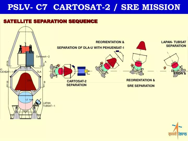
PSLV- C7 CARTOSAT-2 / SRE MISSION. PSLV- C7 CARTOSAT-2 / SRE MISSION. SATELLITE SEPARATION SEQUENCE. REORIENTATION & SEPARATION OF DLA-U WITH PEHUENSAT-1. LAPAN- TUBSAT SEPARATION. REORIENTATION & LAPAN TUBSAT-1 SEPARATION. REORIENTATION & SRE SEPARATION. CARTOSAT-2 SEPARATION.

E N D
PSLV- C7 CARTOSAT-2 / SRE MISSION PSLV- C7 CARTOSAT-2 / SRE MISSION SATELLITE SEPARATION SEQUENCE REORIENTATION & SEPARATION OF DLA-U WITH PEHUENSAT-1 LAPAN- TUBSAT SEPARATION REORIENTATION & LAPAN TUBSAT-1 SEPARATION REORIENTATION & SRE SEPARATION CARTOSAT-2 SEPARATION
PSLV- C7 CARTOSAT-2 / SRE MISSION PSLV- C7 CARTOSAT-2 / SRE MISSION SRE – MISSION PROFILE T0 Velocity: 7350 m/s 22nd Jan 20th Jan Deboost T0 + 35 min Velocity: 8000 m/s 10th Jan T0 + 44 min Velocity: 47 m/s • SRE will be in orbit for nearly 10 days during which it will perform Micro- Gravity experiments • Subsequently it will be moved from Circular orbit to Repeating Elliptical Orbit (REO) • It will de-boosted from REO and will be made to Re-enter and impact nearly 140 km off the coast of SHAR • SRE will be recovered from the Sea T0 + 46 min Velocity: 12 m/s
PSLV- C7 CARTOSAT-2 / SRE MISSION Typical visibility: Prior & Post De-boost RE- ENTRY Altitude : 100 km Latitude : 27 deg Longitude : 84 deg De- Boost END Altitude : 635 km Latitude : 52 deg Longitude : - 105 deg De- Boost START Altitude : 638 km Latitude : 4 deg Longitude : - 92 deg Data down load regions Saskatoon, Svalbard, Lucknow, Air- Borne Telemetry (ABT), Ship Borne Telemetry (SBT), SHAR
PSLV- C7 CARTOSAT-2 / SRE MISSION Air borne Telemetry from SHAR Reentry ground trace Probable impact zone 30x5 km Ship borne Telemetry Chetak Helicopter from Sarang SHAR 15 km 140 km ICG Ship - Sarang CHENNAI 50 km Dornier aircraft from Chennai 50x15 km – Stay out zone for ship DEPLOYMENT OF RECOVERY SYSTEMS