Download
1 / 33
330 likes | 510 Views
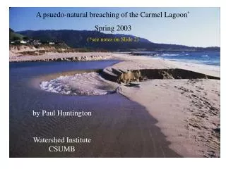
Monterey Peninsula Water Management District. Carmel River Lagoon Update A presentation to the Carmel Point and Lagoon Preservation Association. ● Status of the Study Plan for Long Term Adaptive Management of the Carmel River State Beach and Lagoon ● Lagoon closing in spring 2009 .

E N D
Monterey PeninsulaWater Management District Carmel River Lagoon UpdateA presentation to theCarmel Point and Lagoon Preservation Association ● Status of the Study Plan for Long Term Adaptive Management of the Carmel River State Beach and Lagoon ●Lagoon closing in spring 2009 Thursday, July 23, 2009 by Larry Hampson, Water Resources Engineer
Study Plan for Long Term Adaptive Management of the Carmel River State Beach and Lagoon • The next few slides identify: • The planning area • Why a comprehensive plan is needed • The stakeholders involved • Goals of the plan • Alternatives to be considered • Progress to date
Why a comprehensive plan is needed Issues to address include: • Storms remove sand from along Scenic Road and from the south end of the beach • Homes and infrastructure on the north side of the lagoon are subject to flooding from the river and the ocean • Beach manipulation, Carmel River diversions, and land use within the Carmel River watershed impact the beach and habitat at the lagoon for steelhead and California red-legged frogs
Spring storms remove sand from Stewart’s Cove and from the slope below Scenic Road Scenic Road Stewart’s Cove March 1993
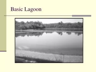
Winter storms remove sand from the basement layer at the southern end of the beach
Extreme ocean storms can fill the lagoon and flood low lying areas January 5, 2008
An outlet to the south results in low water levels April 29, 2009
Carmel River diversions reduce inflow in the spring and summer
Land use in the upper watershed affects beach sand replenishment
High and low water comparison 9 a.m., February 9, 2006, Elev.= 9.5 Lagoon surface area = 90 acres (estimate) 8:30 a.m., February 6, 2006, Elev.= 2.7 Lagoon surface area = 12 acres (estimate)
Higher water levels = higher water quality and more aquatic habitat
Lower water levels expose fish to predators, warm water, higher salinity levels, and lower dissolved oxygen levels
Stakeholders • Big Sur Land Trust • California American Water • California State University Monterey Bay • Carmel Development Company • Carmel River Lagoon Coalition • Carmel River Steelhead Association • Carmel River Watershed Conservancy • Monterey County Service Area 50 • Pebble Beach Company
Technical Advisory Committee • California Coastal Commission • California Department of Fish and Game • California State Parks • Carmel Area Wastewater District • Monterey County Public Works Department • Monterey County Water Resources Agency • Monterey Peninsula Water Management District • NOAA Fisheries • Regional Water Quality Control Board • U.S. Army Corps of Engineers • U.S. Fish and Wildlife Service
Planning Goal – comprehensive management • Decrease potential for flood damage on the north side of the lagoon • Reduce the need to manage the beach • Improve steelhead habitat in the lagoon • Protect Scenic Road • Increase the sand supply to the mouth
General categories of alternatives to be studied • Beach sand replenishment • Structural protection along Scenic Road • Flood proofing of structures • Mechanical control of lagoon elevation (e.g., pump to reduce high levels, install grade control at outlet to raise lowest level) • Create managed outlet channel • Increase dry season flows
Alternatives Analysis • Several scientific studies are needed in order to evaluate alternatives • These studies will provide the information necessary to complete environmental documents (i.e., EIR and EIS) and preliminary plans for alternatives
Progress to Date • Outline of studies was completed in April 2007 • Proposed scope of work was provided to State and Federal elected officials in 2007 and 2008 with a request for funds • Project work is part of the highest-ranked project in the Monterey Peninsula planning region • Funding for certain components of the plan has been requested by CRWC • MPWMD and MCWRA continue to search for grant funds to complete studies and begin work on environmental analysis
How far have we really come? • You can always count on Americans to do the right thing—after they’ve tried everything else. - Winston Churchill
Lagoon closing in spring 2009 • Closing the lagoon before the dry season is timed to fill the lagoon to as high an elevation as feasible before river inflows stop • Closing is the responsibility of the California State Parks Department • State Parks consults with the Lagoon TAC concerning the timing and location of the closure • MPWMD provides data on river inflow, tides, swell height and direction, condition of the beach, and status of steelhead migration
What happens when the lagoon is mechanically closed off before the dry season? • The volume of water and habitat in the lagoon after closure is greater than after a natural closure • Water quality remains high for a longer period during the dry season • Bird predation is decreased • Food and habitat for steelhead rearing is increased
Carmel River Lagoon Cycles Above – just prior to a breach Below – during a breach that empties the lagoon
Carmel River State Beach – spring 2009 May 8, 2009
Using equipment to block the mouth and raise the beach Left - June 11, 2009
Emergency outlet through the south end of the beach May 26, 2009
Main stem Above – 5/18/2009 Right – 6/11/2009
South arm Above – 5/18/2009 Right – 6/11/2009