Download
1 / 16
170 likes | 569 Views
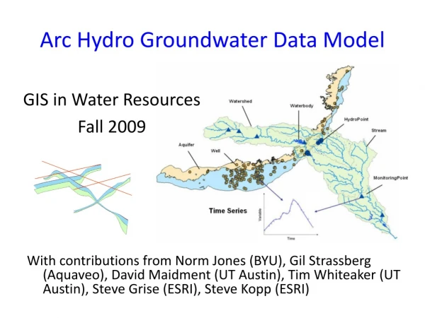
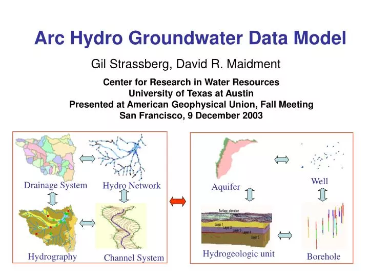
Drainage System. Hydro Network. Well. Aquifer. Hydrography. Channel System. Hydrogeologic unit. Borehole. Arc Hydro Groundwater Data Model. Center for Research in Water Resources University of Texas at Austin Presented at American Geophysical Union, Fall Meeting

E N D
Drainage System Hydro Network Well Aquifer Hydrography Channel System Hydrogeologic unit Borehole Arc Hydro Groundwater Data Model Center for Research in Water Resources University of Texas at Austin Presented at American Geophysical Union, Fall Meeting San Francisco, 9 December 2003 Gil Strassberg, David R. Maidment
Bringing together these two communities by using a common geospatial data model Arc Hydro design took 3 years from 1999 – 2002. Groundwater phase II 2002 - 2005. CRWR GIS CRWR GIS in Water Resources Consortium Water Resources
Geographic Data Model • Conceptual Model – a set of concepts that describe a subject and allow reasoning about it • Mathematical Model – a conceptual model expressed in equations • Data Model – a conceptual model expressed in a data structure • Geographic Data Model – a data model for describing and reasoning about the world A model is a simplification of reality
Analysis, Modeling, Decision Making Arc Hydro Geodatabase Hydrologic information system A Synthesis of geospatial and temporal information that a which supports hydrologic analysis and modeling
Drainage System Hydro Network Flow Time Time Series Hydrography Channel System Arc Hydro data model
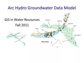
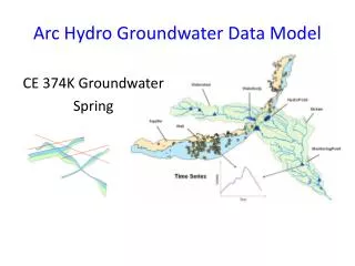
Time Drainage System Hydro Network Time Series Hydrography Channel System Arc Hydro groundwater data model Temporal Surface water Groundwater Well Aquifer Hydrogeologic unit Borehole
Data model design process Empty Geodatabase UML Design Table structures and relationships Structured data Site data Filled geodatabase
ArcGIS features GIS uses features and tables to describe a simplification of a “system” in this case the hydrological description. 3D features: 3D points, 3D lines and 3D polygons 2D features: Points, lines and polygons Points - Wells Polygons - Aquifers 3D points Lines- River network 3D lines -Wells Geodatabase Tables with information Time series 3D polygons
3 Dimensional representation Describing aquifer architecture, hydrogeologic parameters and related temporal data Temporal data Savannah River Site
Interfacing with the data model Data model geodatabase Custom tools A database that matches information required to execute a specific model (e.g. MODFLOW) Models Model interface Simulation Models
Example of Savannah River Site MODPATH simulation MODFLOW model for Savanna River Site
Example of MODPATH GIS has built in tools for tracking over time and space Tracking analyst
Interfacing surface and groundwater models Arc Hydro data model Surface water models Groundwater models Simulated results Simulated results
Integrated simulation Groundwater simulation Surface water simulation
Key points • Arc Hydro is a geographic data model – basis for hydrological information system • Extended to include the main features of groundwatersystems • Provide a data interface between ArcGIS and commonly used groundwater modeling programs • Integration of models through the data model.
Questions? For more information: Gil Strassberg: gilstras@mail.utexas.edu David Maidment: maidment@mail.utexas.edu