Download
1 / 34
350 likes | 369 Views
Explore different air masses influencing Lexington weather, frontal types, precipitation patterns, cyclone stages, and midlatitude cyclone formation. Learn about directional and speed divergence, Nor'easters, hurricanes, and more.

E N D
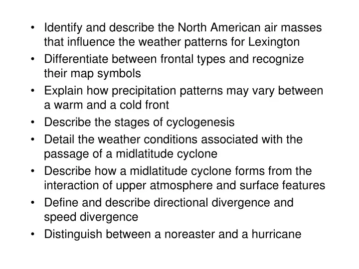
Identify and describe the North American air masses that influence the weather patterns for Lexington • Differentiate between frontal types and recognize their map symbols • Explain how precipitation patterns may vary between a warm and a cold front • Describe the stages of cyclogenesis • Detail the weather conditions associated with the passage of a midlatitude cyclone • Describe how a midlatitude cyclone forms from the interaction of upper atmosphere and surface features • Define and describe directional divergence and speed divergence • Distinguish between a noreaster and a hurricane
Air mass • Large body of air with uniform temperature and moisture • Air acquires characteristics from underlying surface • Two dominant air masses influence eastern US • Maritime tropical (mT) from Gulf of Mexico/Atlantic • Warm and moist; potentially unstable • Continental polar (cP) from interior of Canada • Cool and dry; stable
Our single-digit temperatures are caused by Arctic air masses instead of Canadian ones.
Fronts • Boundary between two air masses • Type of front is designated by the air mass that is moving • Cold front-cold advances on warm • Warm front-warm advances on cold • Stationary front-neither warm nor cold air mass is moving
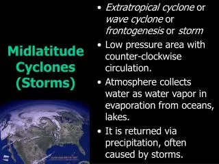
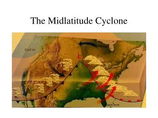
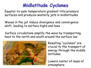
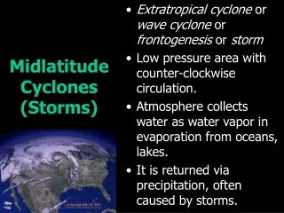
Midlatitude cyclones • Large low pressure storm system consisting of a warm and cold front • Dominant weather system for US in winter Develops along the polar jet stream • Migrate W to E • Also called wave cyclones • Can create predictable contrasts in weather conditions over a couple of days • Since they occur in conjunction with the polar jet stream, they are mainly active at our latitude in Lexington during the fall through spring
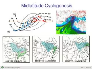
Cyclogenesis – formation of a midlatitude cyclone • Requires interaction of surface and upper atmospheric processes • MLCs are a deep atmospheric phenomena • Surface conditions needed: • Strong baroclinity, i.e., a sharp contrast in temperatures over a short distance. This enhances surface low pressure and instability • Upper atm conditions: • Trough in polar jet stream, i.e., an upper level low pressure Polar front is location where both criteria met
Cold air High pressure ridge Open high (circulation is not closed) Warm air Low pressure trough Open low (circulation is not closed). The trough creates downstream speed and directional divergence that enhances instability Geostrophic winds on a map of geopotential heights Surface winds on a surface isobaric map
Early stage Open wave stage Zone of strong surface baroclinity Dissipating stage MLCs lose organization 7-10 days after redistributing the heat that powers them Occluded stage Occluded front formation marks a decaying MLC.
MLC’s act to balance the heat budget 2. Azonal polar jet stream flow (waves develop in the polar jet stream) 1. Zonal polar jet stream flow 3. Back to zonal flow
MLC circulation creates lifting and potential for precipitation Conveyers belts are areas in a MLC where lifting occurs and thus where there is the potential for precipitation
Nor’easter • Strong midlatitude cyclone that moves up the US East coast • Requires strong polar jet stream support (troughing with speed and directional divergence) • Intensity fueled by strong baroclinic zone along land-sea border (large temperature contrasts between cold land and warm sea) • Bombing: extreme drop in central barometric pressure of a nor’easter
Nor’easters • Produce heavy snowfall events for the southeast, mid-Atlantic, and New England • Can produce winds as strong as a hurricane • May last for several days and impact a large coastal area (hurricane damage often restricted to a much smaller area)
Famous nor’easters • Storm of the Century (1993) • The Perfect Storm (1991) • Ash Wednesday Storm (1962).
(3/1993) Storm of the Century Hurricane-strength winds on west coast of Florida
Ash Wednesday Storm (also called the Five High storm because it lasted five days)
Superstorm Sandy • Began as a hurricane • Tropical storm characteristics merged with nor’easter (extratropical) conditions • Hybrid storm • Created large wind field