Download
1 / 15
150 likes | 189 Views
Millennium Ecosystem Assessment Northern Australia floodplain and coastal wetlands. Max Finlayson National Centre for Tropical Wetland Research Darwin, NT. Northern Australia floodplain and coastal wetlands. Aim Participation Geographic Region / Location Data sources / Scale Components

E N D
Millennium Ecosystem AssessmentNorthern Australia floodplain andcoastal wetlands Max Finlayson National Centre for Tropical Wetland Research Darwin, NT
Northern Australia floodplain andcoastal wetlands Aim Participation Geographic Region / Location Data sources / Scale Components Next steps
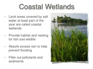
Aim Provide information on the floodplain and coastal ecosystems and their services at multiple scales and taking into account multiple pressures
Geographic Region / Location Northern Australia – east of Darwin Coastal biogeographic region Alligator Rivers – 28 000 km2 Catchments of three rivers Kakadu National Park – World Heritage & Ramsar listed
Participation Discussed through existing panels, boards • Biophysical scientists • Social scientists • Management agencies • Local community / indigenous • Private sector
Data sources • Information derived from current or planned projects • Biophysical features – extensive; ready access • Social/cultural features – extensive; discuss access • Floodplain services – variable; derived from biophysical data and managers • Pressures – extensive analyses; risk assessments underway
Scale • Biogeographical or catchment scale 1:100 000 to 1:250 000 • Catchment scales 1:50 000 to 1:100 000 • Habitats / river reaches 1:10 000
Components • Inventory/mapping – GIS multiple scale • Floodplain services – indigenous, biodiversity, tourism, recreation (fish stocks, mitigation of climate change, cattle grazing) • Risk assessment of major pressures – invasive species, water pollution, infrastructure, burning, climate change
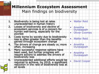
Scale (nominal) Level 1 River basin or island Geology; climate; landcover 1:1 000 000 Level 2 Location; altitude; area; land systems; climate; hydrology; vegetation Wetland region 1:250 000 Level 3 Wetland complex Location; physico-chemical and biological features; classification; jurisdiction; ecosystem services 1:50 000 Level 4 Location; physico-chemical and biological features (ecological character); land tenure; land use; management issues and threats... Wetland habitat Basic (“Core”) dataset stored in Database with GIS Interface Hierarchical approach to wetland inventory
The Risk Assessment Framework(modified from van Dam et al. 1999; Ramsar 2000)
Next steps Further consultation – with participants, advisors and stakeholders Collation / analysis – based on previous and current projects Communication – discussing and finalising analyses and outcomes