Download
1 / 19
200 likes | 357 Views
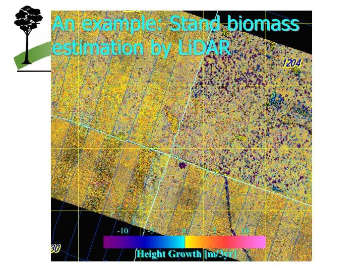
-10. -5. 0. 5. 10. Height Growth [m/3yr]. An example: Stand biomass estimation by LiDAR. Stand biomass by LiDAR & Stand Density Chart. Stand Height. RMSE = 53.0 m 3 /ha Bias = -20.9 m 3 /ha Ratio of contribution = 0.94. Stand Density. Biomass. LiDAR Large footprint.

E N D
-10 -5 0 5 10 Height Growth [m/3yr] An example: Stand biomass estimation by LiDAR
Stand biomass by LiDAR & Stand Density Chart Stand Height RMSE = 53.0 m3/ha Bias = -20.9 m3/ha Ratio of contribution = 0.94 Stand Density Biomass
LiDARLarge footprint Harding, D.J., Lefsky, M.A., Parker, G.G., Blair, J.B., 2001. Laser altimeter canopy height profiles: methods and validation for closed-canopy, broadleaf forests. Remote Sensing of Environment 76, 283-297.
Lefsky, M.A et al. 1999. Remote Sensing of Environment 70, 339-361.
Do we actually tell you the truth by RS? • Need the accuracy control • How can we disseminate the developed techniques to the real forest management?
Real world vs. satellite view Real land cover Satellite map vs.
Real world vs. satellite viewError Matrix (real) Error Matrix Overall Accuracy K statistics Real land cover vs. Satellite map
Real world vs. satellite viewError Matrix (random sample) Error Matrix / Multinominal Sampling Overall Accuracy K statistics Real land cover vs. Satellite map
Real world vs. satellite viewError Matrix (random sample) Error Matrix / Multinominal Sampling Area Estimation Real land cover vs. Satellite map
Real world vs. satellite viewError Matrix (stratified sample) Error Matrix / Stratified Sampling (Sat map) Overall Accuracy Real land cover vs. Satellite map
Real world vs. satellite view Error Matrix (stratified sample) Error Matrix / Stratified Sampling (Sat map) Area Estimation Real land cover vs. Satellite map K statistics
Accuracy evaluation is really awful • So many samples to make the result statistically relevant • On the field, we can never be ‘random’ • Many researches using RS skipped/ignored/pretended this process • Sometimes they induced problematic aftermath • How can we make them meaningful?
Activities in Forested Landscapes FM/LM Measurement SFM/SLM RS C&I Research How can we disseminate RS to the real forest management?
But… • Why? • How can we overcome? Remote sensing has not yet succeeded in the practical world – the world of application. Franklin (2001) “Remote Sensing for Sustainable Forest Management”
Why RS is successful in researches, but not in real SFM? • No universal answers • Result here cannot be applied to there • What are the universal tendency of forested landscapes? • Ground truths expensive • Pitfall of ‘Professional’ monitoring • How to re-use the existing knowledge? • Credibility/accuracy • Khat syndrome, but actually makes sense? • Minimum guideline for assessable result • User’s capacity • Colorful Landsat image cannot intuitively be understood • High resolution image interpretation – intuitive & interesting
For real use of RS, simple methods have been longed for • Less skill/equipment demanding • More intuitive analyses • Simpler procedures • More talks between the users and the RS specialists
Conclusion • RS has been expected to contribute to the forest measurement and monitoring • Many methods have been developed • There are new sophisticated sensors and analysis techniques • Appropriate use will contribute to solve the mysteries in forests • To make RS work in the real world, we should also consider the impact of RS on the users/decision makers
Thank you for your attention For more discussion, contact G.Takao@cgiar.org
Chambers, J.Q et al., 2007. Regional ecosystem structure and function: ecological insights from remote sensing of tropical forests. TRENDS in Ecology and Evolution 22, 414-423.