Download
1 / 34
340 likes | 805 Views
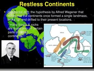
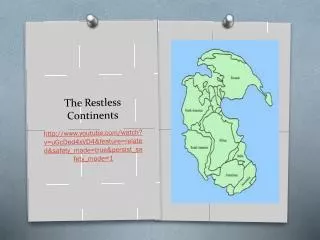
Ocean Currents. Masses of water that flow from one place to anotherOcean currents can be either deep or surface. Ocean Circulation Patterns. Gyre: Current system within an ocean basin. Main types of gyres. North PacificSouth PacificIndian OceanNorth AtlanticSouth Atlantic. Ocean Circulation patterns (cont.).

E N D
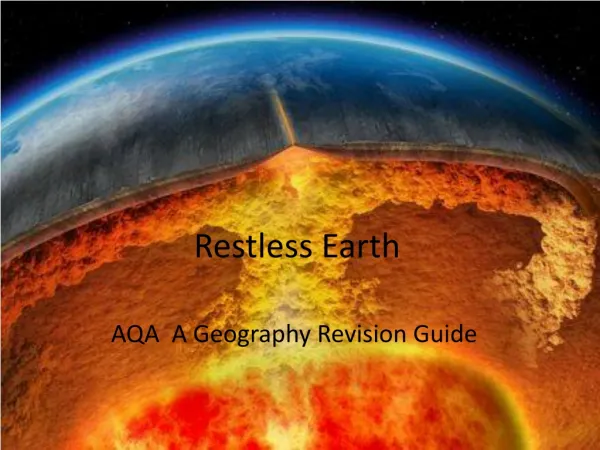
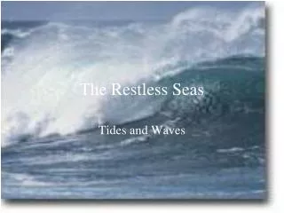
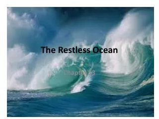
1. The Restless Ocean
2. Ocean Currents Masses of water that flow from one place to another
Ocean currents can be either deep or surface
3. Ocean Circulation Patterns Gyre: Current system within an ocean basin
4. Main types of gyres North Pacific
South Pacific
Indian Ocean
North Atlantic
South Atlantic
5. Ocean Circulation patterns (cont.) The center of each gyre is about 30oN or 30oS latitude.
These are known as subtropical gyres
6. Subtropical gyres Subtropical gyres move clockwise in the Northern Hemisphere and counterclockwise in the Southern Hemisphere
The primary factor that influence the movement of ocean water is called the Coriolus effect
7. Ocean currents play a major role in maintaining Earth�s heat balance
This is accomplished by transferring heat from the tropics to the poles
8. North Atlantic gyre Gulf stream
North equatorial current
North Atlantic current
Canary current
9. Upwelling Upwelling is the rising of cold water from deeper layers to replace warmer surface water
Upwelling also brings greater concentrations of dissolved nutrients, such as nitrates and phosphates, to the surface
10. Deep ocean circulation Deep ocean circulation accounts for the thorough mixing of deep-water masses
This component of ocean circulation is based on density differences
These density variations can be caused by temperature and salinity
This is referred to as a thermohaline
11. The shoreline The shoreline is the dynamic interface among, land and sea
The shoreline is where continental and oceanic processes converge
The shoreline serves as a transition zone between continental and marine environments
The shoreline is constantly being bombarded by waves
12. Waves Ocean waves are energy traveling along the interface between ocean and atmosphere
Ocean waves often transfer energy from a storm far out at sea over distances of thousands of miles
13. Wave characteristics Wave crest: The top of a wave
Trough: the bottom of a wave
Wave height: distance between the crest and the trough
Wavelength: Horizontal distance from crest to crest or from trough to trough
Wave period: The amount of time for a wave to pass a fixed position
14. Wave height, wavelength and wave period are dependent upon three factors:
1) wind speed
2) length of time that the wind has blown
3) fetch: the distance the wind has traveled across open water
15. Wave speed and length As wave speed and length decreases, the waves eventually grows higher and eventually breaks
The turbulent water caused by breaking waves is called surf
16. Beaches Beaches consists of whatever material that is commercially available
On the Florida coast (a low latitude region), beaches have a biological component, such as shell fragments
Waves that crash along the seashore transport material along the beach
17. Shoreline features Two types of shoreline features:
1) erosional
2) depositional
18. Erosional features Features that owe their origin from erosion
Examples: wave-cut cliffs, wave-cut platforms, marine terraces, sea arches and sea stacks
19. Wave-cut cliffs Surfaces produced by the cutting of the surf against the base of coastal land.
20. Wave-cut platform A platform that is left behind by a receding cliff
21. Marine terrace This is when a wave-cut platform is uplifted above sea level by tectonic forces (such as volcanism)
22. Sea arches & sea stacks Sea arch: An arch formed by erosion when opposite sides of a headland unite
Sea stack: An isolated mass of rock standing just offshore produced by wave erosion of a headland
23. Depositional features These are features produced by the deposition of sediment
The sediment is transported along the shore and deposited in areas where wave energy is low
Examples: spits, bars, tombolos, barrier islands
24. Spits, bars, and tombolos A spit is an elongated ridge of sand that projects from the land into the mouth of an adjacent bay
Bar: this is a sandbar that completely crosses a bay, sealing it off from the open ocean
Tombolo: A ridge of sand that connects an island to the mainland or another island
25. Barrier islands A low, elongated ridge of sand that parallels the coast
Examples: Padre Island National Seashore (Texas), Cape Hatteras (North Carolina)
26. Barrier Islands (cont.) Most barrier islands are 1 to 3 miles wide and 2 to 20 miles long
Barrier islands are separated from the main coast by lagoons, which are relatively quiet bodies of water
27. Tides Periodic changes in the elevation of the ocean�s surface
Caused by the gravitational force of the moon
28. The sun also effects tides, but a much smaller amount than by the moon
The tidal bulges migrate as the moon revolves around the Earth every 29 � days
The tidal cycle is a monthly cycle
Two types of tides: spring tides and neap tides
29. Spring tides The highest tidal range. Occurs between the times of the full and new moons
At this time, the sun and moon are aligned and their forces are added together
The result is larger tidal bulges and larger tidal troughs
Spring tides occur twice a month when the Earth-moon-sun system are aligned
30. Neap tides The lowest tidal range
Occurs twice a month, about the time of the first and third quarters of the moon
The gravitational of the moon and sun act on Earth at right angles
31. Each month, there are two spring tides and two neap tides, each about one week apart
32. Tidal Patterns Three main tidal patterns worldwide:
1) Diurnal tidal pattern
2) Semi-diurnal tidal pattern
3) Mixed tidal pattern
33. Diurnal tidal pattern Characterized by a single high tide and a single low tide each tidal day
Usually occurs at the Northern shore of the Gulf of Mexico
34. Semidiurnal tidal pattern Exhibited by two high tides and two low tides each tidal day
Marked by two high tides of the same height and two low tides of the same height
Very common along the Atlantic coast of the United States
35. Mixed tidal pattern Similar to semidiurnal tidal patterns, characterized by large inequalities of high tide height, low tide height or both
Two high tides and two low tides each day, with high tides of different heights and low tides of different heights
This tidal pattern is prevalent along the Pacific coast of the United States