Download

1 / 31
340 likes | 542 Views
Image Preprocessing: Radiometric and Geometric Correction. John R. Jensen Department of Geography University of South Carolina Columbia, South Carolina 29208. Jensen 2003. Image Preprocessing: Radiometric Correction. Jensen 2003. Solar and Heliospheric Observatory (SOHO)

E N D
Image Preprocessing: Radiometric and Geometric Correction John R. Jensen Department of Geography University of South Carolina Columbia, South Carolina 29208 Jensen 2003
Image Preprocessing: Radiometric Correction Jensen 2003
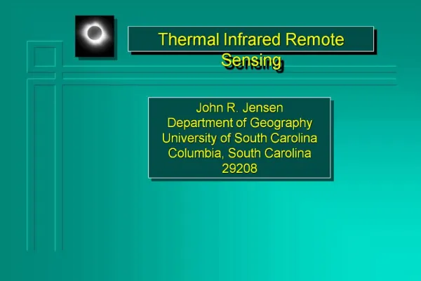
Solar and Heliospheric Observatory (SOHO) Image of the Sun Obtained on September 14, 1999 Jensen 2003
Sources of Electromagnetic Energy Jensen 2003 Thermonuclear fusion on the surface of the Sun yields a continuous spectrum of electromagnetic energy. The 6,000 K temperature of this process produces a large amount of short wavelength energy (from 0.4 - 0.7 m; blue, green, and red light) that travels through the vacuum of space at the speed of light. Some energy is intercepted by the Earth where it interacts with the atmosphere and surface materials. The Earth may reflect some of the energy directly back out to space or it may absorb the short wavelength energy and then re-emit it at a longer wavelength.
Blackbody Radiation Curves Blackbody radiation curves for several objects including the Sun and the Earth which approximate 6,000 K and 300 K blackbodies, respectively. Notice that as the temperature of the object increases, its dominant wavelength shifts toward the short wavelength portion of the spectrum. Jensen 2003
Radiant Intensity of the Sun The Sun approximates a 6,000 K blackbody with a dominant wavelength of 0.5 m (green light). Earth approximates a 300 K blackbody with a dominant wavelength of 9.7 m . The 6,000 K Sun produces 41% of its energy in the visible region from 0.4 - 0.7 m (blue, green, and red light). The other 59% of the energy is in wavelengths shorter than blue light (<0.4 m) and longer than red light (>0.7 m). Eyes are only sensitive to light from the 0.4 to 0.7 m. Remote sensor detectors can be made sensitive to energy in the non-visible regions of the spectrum. Jensen 2003
Electromagnetic Spectrum The Sun produces a continuous spectrum of energy from gamma rays to radio waves. The visible portion of the spectrum may be measured using wavelength (measured in nanometers or micrometers, i.e. nm or m) or electron volts (eV) terminology. All units are interchangeable. Jensen 2003
Irradiance and Exitance The amount of radiant flux incident per unit area of a plane surface is called Irradiance (E), where: E • The amount of radiant flux leaving per unit area of the plane surface is called Exitance (M). M • Both quantities are measured in watts per meter squared (W m-2). Jensen 2003
Radiant Flux Density The concept of radiant flux density for an area on the surface of the earth. Irradiance is a measure of the amount of incoming energy in Watts m-2.Exitance is a measure of the amount of energy leaving in Watts m-2. Jensen 2003
Radiance Radiance (L) is the radiant flux per unit solid angle leaving an extended source in a given direction per unit projected source area in that direction and is measured in watts per meter squared per steradian (W m-2 sr -1 ). We are only interested in the radiant flux in certain wavelengths (L) leaving the projected source area (A) within a certain direction () and solid angle (): L cos This is the most precise remote sensing radiometric measurement. Jensen 2003
The concept of radiance leaving a specific projected source area on the ground, in a specific direction, and within a specific solid angle.This is the most precise radiometric measurement used in remote sensing. Jensen 2003
Radiometric Quantities Hemispherical reflectance (r) is defined as the dimensionless ratio of the radiant flux reflected from a surface to the radiant flux incident to it: reflected r Jensen 2003
Radiometric Quantities We often take the hemispherical reflectance equation and multiply it by 100 to obtain an expression for percent spectral reflectance (pr), reflected prx 100 This quantity is used in remote sensing research to describe the general spectral reflectance characteristics of various phenomena. Jensen 2003
Reflectance Jensen 2003
Spectral Reflectance Curves of Selected Materials Jensen 2003
Spectral Bandwidths of Landsat and SPOT Sensor Systems Jensen 2003
Atmospheric Scattering The type of scattering is a function of: • the wavelength of the incident radiant energy, and • the size of the gas molecule, dust particle, or water vapor droplet encountered. Jensen 2003
Rayleigh Scattering The intensity of Rayleigh scattering varies inversely with the fourth power of the wavelength (-4). Jensen 2003
Absorption of the Sun's Incident Electromagnetic Energy in the Region from 0.1 to 30 m by Various Atmospheric Gases Jensen 2003
Energy-matter Interactions in the Atmosphere, at the Study Area, and at the Remote Sensor Detector Jensen 2003
Path 1: EMR from the Sun that was attenuated very little before illuminating the terrain within the IFOV Path 2: EMR that may never reach the Earth’s surface because of scattering in the atmosphere. Unfortunately, such energy is often scattered into the FOV of the sensor system Jensen 2003
Path 3: Contains energy from the Sun that has undergone some Rayleigh, Mie, and/or Non-selective scattering and perhaps some absorption and re-emission before illuminating the study area. Thus, its spectral composition and polarization may be somewhat different than the energy in Path 1. Path 4: Radiation that was reflected or scattered by nearby terrain such as snow, concrete, soil, water,and/or vegetation into the IFOV of the sensor system. The energy does not actually illuminate the study area.
Path 5: Energy that was reflected from nearby terrain into the atmosphere and then scattered or reflected onto the study area. Path 2 and Path 4 combine to produce what is commonly referred to as Path Radiance, Lp. Jensen 2003
Correction for Sensor System Detector Error Sometimes the remote sensing system simply does not function properly. Several of the more common radiometric errors include line drop-outs, striping or banding, and line-start problems. Correction for a line drop-out problem: This is performed for every pixel in a bad scan line. Jensen 2003
Radiometric Correction Using the ATmosphere REMoval (ATREM) Program ATREM calculates scaled surface reflectance values from hyperspectral radiance data using an approximate atmospheric radiative transfer modeling technique. Radiative transfer modeling is used to calculate the atmospheric transmittance of gases and molecular and aerosol scattering. The water vapor amount is derived on a pixel by pixel basis using the 0.94 mm and 1.14 mm water absorption bands and a three channel ratioing technique where several bands in the water absorption feature are averaged and ratioed against two sets of averaged window channels adjacent to the water absorption feature. Additional inputs: - Select up to 7 atmospheric gases that may be modeled and removed during the reflectance calculation - An aerosol model. - Visibility conditions during the overflight (e.g., 10 km) - Standard atmospheric model - Average surface elevation (km) - Scene center latitude and longitude - Aircraft altitude above sea level (km) Jensen 2003
Radiometric Correction Using Empirical Line Calibration Empirical Line calibration forces remote sensing spectral data (radianceimage) to match selected field reflectance spectra (Fieldspectra). A linear regression is developed for each band to equate the brightness value in the imagery with the in situ reflectance measurements. This is equivalent to removing the solar irradiance and the atmospheric path radiance. The following equation shows how the empirical line gain and offset values are collected: Typically, the analyst chooses a dark and a bright region in the image for use in the empirical line calibration. Of course, in situ reference calibration data must be available for these areas. Using as many paired data/field spectra as possible improves the calibration. At least one spectral pair is necessary.
Paired Relationship: Bright Target Band 1 Fieldspectra 48 49 Band 2 One Bright Target Remote measurement 47 48 Band 3 55 54 Radiance Dark Target 48 50 54 57 40 40 Remote Measurement m = 49 55 56 40 39 Fieldspectra= 55 m = 55 F = 59 42 41 Band 1 Band 2 Band 3 Wavelength, nm • = 41 F = 48 Band 1 Bright Target 9 10 Band 2 One Dark Target 10 11 5 4 Band 3 Dark Target 12 10 6 5 0 0 Fieldspectra Remote Measurement m = 11 4 6 0 4 Fieldspectra= 13 m = 5 F = 7 2 1 m = 3 F = 4 Radianceimage (e.g., Band 1) Jensen 2003
Multiple Date Image Normalization Using Regression Example based on SPOT imagery obtained over Water Conservation 2A in South Florida Jensen 2003
Cosine Correction for Terrain Slope where: LH = radiance observed for a horizontal surface (i.e., slope-aspect corrected remote sensor data). LT = radiance observed over sloped terrain (i.e., the raw remote sensor data) q0 = sun’s zenith angle i = sun’s incidence angle in relation to the normal on a pixel Jensen 2003