Download
1 / 15
260 likes | 756 Views
Chapter 2 (Part 2). Geophysical Surveys. Geophysical Surveys. Geophysics: the study of the physics of the earth, its oceans, and its atmosphere. What are petroleum geologists looking at? Earth’s magnetism Gravity Seismic vibrations / Vibrations of the earth. Geophysical Surveys. Types:

E N D
Chapter 2 (Part 2) Geophysical Surveys
Geophysical Surveys • Geophysics: the study of the physics of the earth, its oceans, and its atmosphere. • What are petroleum geologists looking at? • Earth’s magnetism • Gravity • Seismic vibrations / Vibrations of the earth
Geophysical Surveys • Types: • Magnetic and Electromagnetic Surveys • Gravity Surveys • Seismic Surveys
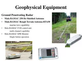
Magnetic and Electromagnetic • Basement rock typically has magnetic properties • Typically Two Types of Surveys: • Magnetometer Surveys • Magnetollurics
Magnetometer Survey - Magnetometer is towed behind an airplane or ship. - Transmits data to an onboard computer that records the data. - Micromagnetic Technique is used to determine micromagnetic anomalies or deviations
Magnetotellurics • The theory that rocks of differing composition have different electrical properties. • Geologist record and measure flow of electricity between rocks or across salt water. • Analyze and interpret the data to reveal subsurface structures.
Gravity Surveys • Scientist look for slight variations in the earth’s gravitational field caused by the varying weight of rocks. • Very Dense rocks (Weigh more) near the surface exert a higher gravitational force than those of lower density. • Salt domes are associated with minimum gravity • Ordinary Domes and Anticlines are associated with maximum gravity • Tools of the trade: • Torsion Balance • Gravimeter ‘or’ Gravity Meter
Seismic Surveys (Seismology) • Surveys taken by small artificial “seismic events” bounce energy through the earth’s surface. • Different layers in the earth “bounce” differently such as sand vs. rock. • Sensors “Geophones” pick up the reflected seismic waves and send them to a recorder. • Recorder “Seismograph” amplifies and records their characteristics called a seismogram • Seismogram generates a two dimensional slice of the earth from the surface downward called a seismic section.
3D Seismic Surveys • http://www.youtube.com/watch?v=f1GeNljM0T8&feature=related
Early Methods • Dr. L. Mintrop: • German Scientist who developed one of the first practical uses of seismic data. • He invented a portable seismograph. • Used it during World War 1 • Determined the position of the allies artillery by setting up three seismographs opposite the enemy. • Later came to the Texas Gulf Coast and started the Gulf Production Company specializing in seismic exploration
Explosive Methods • http://www.youtube.com/watch?v=jc38hj9JQ_4
Marine Seismic Methods • Typically same methods as on land, but it uses hydrophones (marine version of the geophone)
Questions • Define Geophysics. • List and describe the three types of surveys. • What are the two types of Magnetic Surveying? • Is basement rock typically magnetic (yes/No)? • What is a gravity survey? • Define seismology. • List three different methods of seismic surveying. • How do “Thumper Trucks” create seismic activity in the earth’s surface? • What is a geophone called in offshore applications? • How do ships create the seismic “wave” in offshore seismic surveying?