Download
1 / 39
460 likes | 1.12k Views
CAGAYAN AND TAGOLOAN RIVER BASINS. The bio-physical profile of the CDO River Watershed: THE WATERSHED DEFINED. From the fecundity of springs, water gathers volume and force then, in its long journey to the sea, defines the lay of the land … DENR Sec. Victor O. Ramos.

E N D
The bio-physical profile of the CDO River Watershed:THE WATERSHED DEFINED • From the fecundity of springs, water gathers volume and force then, in its long journey to the sea, defines the lay of the land… • DENR Sec. Victor O. Ramos
THE DRAINAGE SYSTEM OF MINDANAO Butuan Bay Gingoog Bay Macajalar Bay Iligan Bay Moro Gulf Davao Gulf
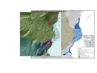
Cagayan de Oro River Basin, Major River Watersheds in Bukidnon, & map of Mt.Kitanglad Plate Source: Moving Forward: Cagayan de Oro River Basin after Sendong, Presented by:BELEN O. DABA, Ph D ; OIC, Regional Technical Director For PAWCZMS
Mt. Kitanglad Range Natural Park Protected Areas within CDO RIVER BASIN Mt. Kalatungan Range Natural Park Plate Source: Moving Forward: Cagayan de Oro River Basin after Sendong, Presented by:BELEN O. DABA, Ph D ; OIC, Regional Technical Director For PAWCZMS
BALIKTANAW SOCIO-ECONOMIC IMPORTANCE OF BUKIDNON: THE WATERSHED OF MINDANAO The people of Bukidnon and a large population in the surrounding provinces depend directly on the Province’ watersheds for water to grow food, generate energy, propel industrial growth, meet domestic needs and provide protection from natural hazards like flooding. WITH GREAT POWERS COME GREAT RESPONSIBILITY…. Spider man
NOT ENOUGH VEGETATIVE COVER The river basin has crucial social physical economic and environmental significance. It is a source of water for domestic industrial, irrigation and for hydro electric power generation. Plate Source: Moving Forward: Cagayan de Oro River Basin after Sendong, Presented by:BELEN O. DABA, Ph D ; OIC, Regional Technical Director For PAWCZMS
ONCE UPON A TIME: A FUNCTIONAL WATERSHED MOSSY FOREST MID MONTANE FOREST LOWLAND TROPICAL RAINFOREST
RECIPE FOR A DISASTER DEGRADED HEADWATERS AND INADEQUATE FOREST COVER IN HIGHLY ELEVATED MOUNTAINS RUGGED AND LENGTHY SLOPES UNPROTECTED FOOTHILLS AND SLOPES POPULATED UPLANDS
RECIPE FOR DISASTER EXTENSIVE AREA OF CDO RIVER CATCHMENT 2. INHOSPITABLE TERRAIN -High Elevation of Headwaters -Steep slope (Continuing Descent Towards CDO) - Rivers Channels flanked by Hillsides, Rockwalls and High Embankments INADEQUATE VEGETATIVE COVER -Not Enough Forest Cover -Degraded Slopes HIGH VOLUME OF RAINFALL AKIN TO TYPHOON SENDONG (300 MM) 5. COINCIDENCE OF HIGH TIDE?
-InHOSPITABLE TERRAIN: TERRAIN CONTINUING DESCENT TOWARDS CDO)
WHITE WATER RAFTING OWES ITS EXISTENCE FROM THE RAPIDS , WHILE THE RAPIDS OWE ITS BEING FROM THE STEEP SLOPES
4 3 1 2 LAND USE MALPRACTICES ALONG THE SLOPES OF CDO RIVER BASIN
1. SITE OF THE MAIN HEADWATER OF CDO RIVER BASIN: THE VALLEY BETWEEN MT KITANGLAD AND MT. KALATUNGAN.
HIGH VOLUME OF RAINFALL Credit: SSAI/NASA, Hal Pierce
THE CHALLENGE: The Task of rehabilitating an ailingCDO WATERSHED RIVER BASIN - restoring its integrity as aLIFE SUPPORT SYSTEM, and protecting itsECOLOGICAL, SOCIO-ECONOMIC CULTURAL FUNCTIONSis one HELL of a job which requiresHEAVENLY interventions!
The Essential Human Requirements however need INTEGRATION OF EFFORTS AND INITIATIVES: Coordination in implementing multi-stakeholders’ interventions and activities Concentration of resources –financial and human, organizational, network, and partners Communication to different stakeholders about the agreed plan: its objectives, strategies, tactics, needs, and opportunities
THE REASON FOR BEING OF THE PLAN • Provides overall guidance, oversight, and direction to multi-stakeholders efforts and initiatives related to the conservation, protection and management of the watershed. • Prescibes the overall strategies and specific measures or courses of actions • Sets the mechanisms for coordination among stakeholders and partners . • Bringssynergy among the various participants in a manner that optimizes efficiency in plan execution.
Mt. Apo Peaks Viewed from Mt. Kalatungan THANK YOU
INTRODUCTION • Profile of the River Basin • HIGHLIGHTS OF THE WORKSHOP/DISCUSSION • SUMMARY OUTPUT OF THE WORKSHOP
Major Tributaries of Cagayan River Watershed • KALAWAIG • TAGITE • BUBUNAOAN • TUMALAONG • BATANG • TIKALA-AN • PIGKUTIN • MONIGUE HEADWATERS – KALATUNGAN MOUNTAIN RANGE
ROLES CURRRENT : PROPOSED a. Contributes to : a. ECOTOURISM biodiversity : * contributes to : biodiversity : * w/ REGIONAL : IMPACT
w/ REGIONAL IMPACT * source of HYDROELECTRIC POWER and IRRIGATION • w/ SOCIO-CULTURAL AND ECONOMIC SENSITIVITY d. FOOD BASKET
CHALLENGES • Weak LGU • Currently – incoming Watershed Masterplan • w/ existing watershed management council • RBCO provided allotment (on creation and strengthening)
c. Communities/LGUs along the river not organized d. Absence of legislative management body e. Some LGUs are complacent on the watershed approach
Absence of an INTEGRATED FRAMEWORK PLAN g. Watershed approach is not fully integrated into LGU plan. Consequently no budgetary allocation (requirements).
PREPARATION OF THE IWMP for Cagayan River Watershed ACTIVITY/SUB ACTIVITY • CHARACTERIZATION/ PREPARATION of various thematic maps • Analysis of THEMATIC MAPS
MILESTONES, TIMELINES, RESPONSIBLE ENTITIES SCHEDULE: ASAP TO 1 – 3 years AGENCY : CORBMC Cagayan de Oro River Basin Management Council
ACTIVITY/SUB ACTIVITY • “REQUIRE” all River Basin communities to form an alliance *CaRBACEPAM– Cagayan River Basin Alliance of Communities for Envi’l Protection and Management OR *CaRBDA – Cagayan River Basin Development Alliance
SCHEDULE: ASAP TO 1 – 3 years AGENCY : Alliance : facilitated by Cagayan de Oro River BasinManagementCouncil 4. Planning
SCHEDULE: ASAP TO 1 – 3 years AGENCY : LGU 5. Adoption of the Plan • 6. Program Implementation SCHEDULE: ASAP TO 1 – 3 years AGENCY : concerned LGU