Download
1 / 10
100 likes | 275 Views
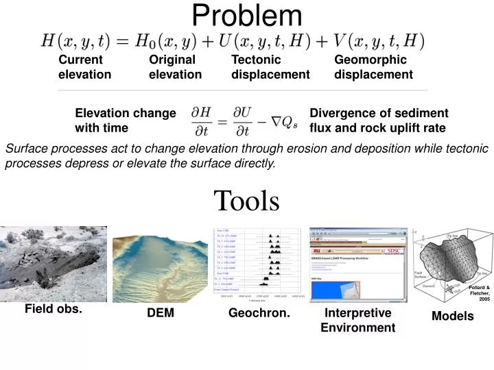
Problem. Current elevation. Original elevation. Tectonic displacement. Geomorphic displacement. Elevation change with time. Divergence of sediment flux and rock uplift rate.

E N D
Problem Current elevation Original elevation Tectonic displacement Geomorphic displacement Elevation change with time Divergence of sediment flux and rock uplift rate Surface processes act to change elevation through erosion and deposition while tectonic processes depress or elevate the surface directly. Tools Pollard & Fletcher, 2005 Field obs. DEM Geochron. Interpretive Environment Models
Tectonic geomorphology • The study of landforms and landscapes which record a measurable tectonic signal (Burbank and Anderson, 2001). A “Poster child” for a landscape that records the record of fold growth: Wheeler Ridge California, view to NW; John S. Shelton photograph
Tectonic geomorphology • How do surficial processes respond to deformation (and what are the possible feedbacks between them)? How can we use the signal of deformation in the landscape (and the late Quaternary) to bridge the gap between annual and Myr timescales?
Active tectonics • What are spatial and temporal scales of continental lithospheric deformation? What are the roles of faulting versus distributed deformation? What drives the deformation? What is the role of pre-existing heterogeneity? Spatial dimensions of W. North American active deformation http://www.earthscope.org/geo_pbo_wp.pdf
Fault system dynamics • What are the spatial and temporal distributions of earthquakes in a region over the (late) Holocene and how do they reflect the regime and the modulation of deformation? What is the effect of mechanical interaction?
Typical range of time scales studied in tectonic geomorphology Thermochronology “No dates, no rates!” Movement towards better access and more differently datable materials and events and more dates for all studies Modified from PBO Geology White Paper http://www.unavco.org/pubs_reports/proposals/pbo/geo_pbo_wp.pdf
Main Pamir thrust in the Pamir-Alai region, Kyrgyzstan Challenge of multiple scales and idealization: How to represent the action of a fault or a channel at the appropriate scale?
http://dmc.earth.sinica.edu.tw/Geophysics/twn_topo.gif Next picture http://www.rcep.dpri.kyoto-u.ac.jp/main/taiwan/data/indexmap-E.html Continuous and homogeneous Discrete and heterogenous 9-21-1999 Chi Chi, Taiwan Earthquake (Mw 7.7)
8 m knickpoint formed in the Chi Chi earthquake near Fengyuen—sending the signal into the landscape
Hierarchical approach to delineation of tectonically active zones • What is the question and why important? Spatial scale • System: km-scale data integration • Structure: Dm-scale structural characterization • Event: cm-scale measure of timing and process