Download
1 / 11
110 likes | 245 Views
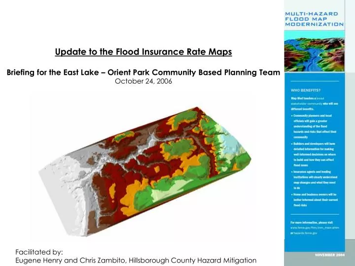
Update to the Flood Insurance Rate Maps Briefing for the East Lake – Orient Park Community Based Planning Team October 24, 2006. Facilitated by: Eugene Henry and Chris Zambito, Hillsborough County Hazard Mitigation. Partners For FEMA’s Map Modernization Program. II.

E N D
Update to the Flood Insurance Rate Maps Briefing for the East Lake – Orient Park Community Based Planning Team October 24, 2006 Facilitated by: Eugene Henry and Chris Zambito, Hillsborough County Hazard Mitigation
Partners For FEMA’s Map Modernization Program II • State and local mapping partners, including CTPs • Mapping Coalition and Member Organizations • American Congress on Surveying and Mapping • American Planning Association • American Public Works Association • American Society of Civil Engineers • Association of State Floodplain Managers • Association of State Wetland Managers • Coastal States Organization • National Association of Counties • National Association of Development Organizations • National Association of Flood and Stormwater Management Agencies • National Association of Home Builders • National Association of Realtors • National Flood Determination Association • National League of Cities • National Lenders Insurance Council • Government Accountability Office • Other Federal Agencies
Sample Change Revised High-Risk Flood Hazard Area Areas Removed By Update
Further Information on Vertical Datum V • County Survey Web Page on Datum Change • http://www.hillsboroughcounty.org/realestate/surveying/about/navd88.cfm
Status of Surrounding Communities • Charlotte - FIRMs completed prior to Map Mod, will begin updates of maps in 2007 • Citrus - Scoping to begin November 2006 • DeSoto - Scoping to be completed by August 2006 • Hardee - Scoping to be completed by August 2006 • Hernando - H&H/floodplain mapping being reviewed, Preliminary maps to be issued to communities by October 2006 • Highlands - Scoping to begin November 2006 • Lake - DFIRMs completed • Levy - Scoping to begin October/November 2007 • Manatee - Scoping to begin October/November 2008 • Marion - Preliminary maps issued in May 2006 (?), PDCC meetings and public workshops held in July 2006 • Pasco - H&H/floodplain mapping being performed, Preliminary maps expected to be released in February 2007 • Pinellas -DIRMs completed prior to Map Mod, will begin updates of maps in 2008 • Polk - Scoping to be completed by August 2006 • Sarasota - H&H/floodplain mapping being performed, Preliminary maps expected to be released in February 2007 • Sumter - Scoping to begin November 2007
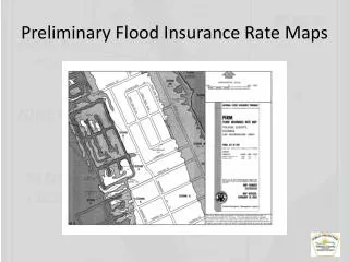
Proposed Flood Hazard Map ***DRAFT*** East Lake/Orient Park Community Planning Area Proposed, High-Risk Flood Hazard Area (Still Water) Proposed, High-Risk Flood Hazard Area (Moving Water) For general information about the upcoming map changes, call the Hillsborough County Citizen Action Center at 813-272-5900. The Center is open at 7am-11pm, 7 days a week. More information is available by going to the following website: http://www.hillsboroughcounty.org/pgm/hazardmit/floodMap/home.cfm
Existing Flood Hazard Map East Lake/Orient Park Community Planning Area Proposed, High-Risk Flood Hazard Area (Still Water) Proposed, High-Risk Flood Hazard Area (Moving Water) For general information about the upcoming map changes, call the Hillsborough County Citizen Action Center at 813-272-5900. The Center is open at 7am-11pm, 7 days a week. More information is available by going to the following website: http://www.hillsboroughcounty.org/pgm/hazardmit/floodMap/home.cfm
Further Information Contacts • Chris Zambito, CFM, Hillsborough County Hazard Mitigation • zambitoc@hillsboroughcounty.org • 813.307.4510 • Eugene P. Henry, CFM, AICP, Hillsborough County Hazard Mitigation • henrye@hillsboroughcounty.org • 813.307.4541 Websites • www.hillsboroughcounty.org • www.floodsmart.gov Call Center (Citizen Action Center) • 813.272.5900 • 7 am – 11pm, 7 Days a Week, Including Holidays