Download
1 / 79
790 likes | 810 Views
Explore the processes that lift air, saturated conditions, cloud types associated with weather phenomena, and wind analysis. Learn about pressure gradients, the Coriolis effect, and friction influencing wind direction. Discover how pressure centers impact weather forecasting and global wind patterns. Gain insights into high and low-pressure systems and their effects on climate conditions.

E N D
WINDS Weather and Climate Day 6
Warm Up • Name the 4 processes that lift air. • Air that has reached its water-vapor capacity is said to be __________. • Which cloud type is a term that means “rainy cloud”? • What clouds are associated with thunder and lightning? • At what percentage is WARM air saturated? How does that change when the air cools?
Announcements • Be sure to do quiz/test corrections if needed! • How are your museum points coming along? Prioritize, make sure you spend time with me after school if you aren’t sure what to do! • Study Guide due on THURSDAY! (Quiz grade!) • Test on THURSDAY!
18.3 Cloud Types and Precipitation What type of cloud is this?
18.3 Cloud Types and Precipitation What type of cloud is this?
18.3 Cloud Types and Precipitation What type of cloud is this?
Objectives • Today I will be able to analyze winds by: • Explaining how wind is generated • Use wind patterns to predict local weather
Key Points • The ultimate energy source for most wind is solar radiation. • Pressure differences generate winds. • A steep gradient produces strong winds. • The Coriolis effect affects wind direction. • High-pressure systems are usually associated with descending air, clear weather, and relatively dry conditions. • The general movement of low-pressure centers across the United States is from west to east. • A sea breeze usually originates in the day and flows toward land. • La Nina is associated with surface temperatures in the eastern Pacific that are COLDER than average (this year)
Air-Pressure Demonstration Watch the demonstration of gradients creating speed. Answer the following questions on your warm up: Pre-Demo: • Which ramp setup do you think will cause the ball to roll the fastest? Post-Demo: • Were you right? Which ramp set up caused it to move the fastest? • Like the ramps, air pressure also forms gradients. Wind is air that flows down the “slopes” of air pressure gradients. • What air pressure conditions do you think would favor faster wind speeds? Steep or shallow gradients?
Air Pressure • Air pressure is the pressure exerted by the weight of the air. • Air pressure is exerted 3-dimensions – down, up, and sideways. The air pressure pushing down on an object exactly balances the air pressure pushing up on the object.
Factors Affecting Wind • Wind is generated by air pressure differences • Air flows from areas of higher pressure to areas of lower pressure. • Air is always trying get to a place with lower pressure. • Solar radiation is the ultimate energy source for most wind. • The sun’s rays heat the earth unevenly, creating pressure differences in the air around us.
Wind • Three factors combine to control wind: pressure gradients, the Coriolis effect, and friction. 1. Pressure gradient: • the amount of pressure change occurring over a given distance. • Pressure gradients generates winds • Remember the ramp? When would be have stronger wind with a steep or gentle gradient? • Steep pressure gradient produces strong winds.
Winds • The Coriolis Effect • The Coriolis effect affects wind direction. Remember the Coriolis effect from oceans? How does it affect ocean currents in the Northern Hemisphere? • It deflects them in different directions for each Hemisphere. • In that same way, it affects wind direction!
Winds • The Coriolis Effect and how it changes wind DIRECTION
Winds 3. Friction • Friction acts to slow air movement, which changes wind direction.
Pressure Centers and Winds Weather Forecasting • Knowing that air pressure causes winds, how could that help meteorologists predict global weather patterns? • Scientists study pressure differences and use data to predict where wind is taking weather! • If scientists measure decreased pressure in Henderson, how could that affect the weather? • Wind would be stronger, and it could carry a storm.
Pressure Centers and Winds Weather and Air Pressure • Low pressure - Produces rising air in association with cloud formation and precipitation. STORMY • High pressure – Produces sinking air causing clear weather, and dry conditions. • What type of weather would you expect when there is a high pressure system? • High-pressure systems are usually associated with descending air, clear weather, and relatively dry conditions.
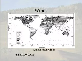
Pressure Centers and Winds Global Wind Patterns • This system moves warm air toward high latitudes and cool air toward the Equator. • Non-Rotating Earth Model • If the earth did not rotate, air at the equator would rise and move straight towards the poles. • Because our earth ROTATES wind patterns are broken up into three main winds: • Trade winds • Westerlies • Polar Easterlies
Pressure Centers and Winds • Trade winds are a surface wind that blows between the subtropical high and the equator. • Westerliesare the dominant west-to-east motion of the mid-latitudes. • Polar easterlies are winds that blow from the polar high downward from east to west. These winds are not constant like the trade winds.
The United States is most effected by Westerlies. • Because of the Westerlies, the general movement of low-pressure centers across the United States moves from ______________ to _____________.
Warmup • What are the lines called that connect points of equal temperature? • What are the lines called that connect points of equal pressure? • What are the lines called that connect points of equal elevation? • What is the map called that connects points of equal elevation?
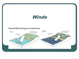
Regional Wind Patterns • Not all winds fall into the general patterns of Global Winds. They can be determined on a more “regional” scale, affecting a smaller area. • Land and Sea Breezes • A sea breeze usually originates during the day and flows toward land. • At night, the wind will come from the land and blow towards the sea.
Regional Wind Patterns • Land and Sea Breezes Remember from our OCEANS unit – WIND is one of the first things you notice when you go to the beach! If you stand facing the water at 8:00 pm would the wind hit you in the face or in the back? What about at 10:00 am?
Regional Wind Patterns • Valley and Mountain Breezes • In the day, the air on the mountains is heated more intensely than air on the valley floor. • Because this warmer air on the mountain slopes is less dense, it glides up along the slope and generates a valley breeze. • After sunset the pattern is reversed. It is warmer on the valley floor and wind glides down.
Regional Wind Patterns • Valley and Mountain Breezes
Wind Direction • Winds are measured by speed and direction. • A prevailing wind is one that has a constant speed and direction • In the United States, in what direction does the wind blow low pressure systems? • From West to East across the continent.
El Niño • In recent years, our planet has had some severe weather that has been contributed to el Niño or la Niña. • El Niño: • El Niño isthenamegiventotheperiodicwarmingthatoccurs in the central and easternPacific. • This happens when the Pacific Ocean is heated more than usual. • This disrupts weather patterns globally causing EXTREME weather patterns. • A major El Niño episode can cause flooding in many parts of the world. • The currents, wind, and moisurecan be affected by el Niño. • THINK: What sort of effect could El Niño have on oceans? How could this impact humans?
La Niña • La Niña • This weather condition is the opposite of el Niño: • La Niña occurs when the surface temperature in the Eastern Pacific are COLDER than average. • This also causes extreme weather patterns. • This year we are experiencing La Niña – what are some weather conditions that you’ve heard about on the news that might be caused by la Niña?
Bottom Line • Global climates can be explained if knowledge of global winds and weather systems are applied.
Check In – Use Complete Sentences • What is the ultimate energy source for most wind? • Which FORCE generates winds? • A STEEP pressure gradient produces which type of winds? • What part of the wind does the CORIOLIS EFFECT influence? • What type of weather is associated with HIGH Pressure systems? What about with LOW? • Low Pressure centers move across the US from ___________ to _____________ direction. • Explain the pattern of sea breezes. • Which phenomenon is associated with surface temperatures in the eastern Pacific that are colder than average?
Study Guide Work Time • Your study guide will be due on THURSDAY for a QUIZ grade. • Use this time wisely to work on the first 22 questions. • My data shows that students who complete the study guide and turn it in on time have 80% average on their tests! Make this count!
Brownie Ticket • What is the ultimate energy source for most wind? • Earth’s rotation • Earth’s revolution • Solar radiation • Tides • The Coriolis Effect influences wind _________. • A sea breeze usually originates during the: • Evening and flows toward the land • Day and flows toward the land • Evening and flows toward the water • Day and flows toward the water
Warmup • What are 2 weather conditions associated with HIGH pressure systems? • Which force generates winds: • The Coriolis Effect • Gravity • Pressure differences • Friction • Name the phenomenon that is associated with surface temperatures in the eastern Pacific that are colder than average.
Warm up • What force generates winds? • The Coriolis Effect influences what property of winds? • The dominant type of global wind for the US is _________________, and these move from _______ to _______ • What weather conditions are associated with high pressure? Low pressure? • Where do sea breezes originate?
Weather FrontsObjectives • Today I will be able to: • Describe the factors that characterize air masses • Analyze the development of fronts when air masses meet
Weather FrontsKey Points • Air masses are characterized based on their temperature and moisture • Air masses pick up the characteristics of the land they go over • Ex: a cold, dry air mass that moves over warm, tropical waters will become warmer and wetter • Fronts are boundaries that separate air masses • Warm fronts are shown by a line with semicircles • Cold fronts are shown by a line with triangular points • Along a front, warm air is always forced upward • Along cold fronts, precipitation is generally heavy, but short-lived
Air Masses and Weather • Weather patterns result from the movement of large bodies of air called air masses • Air masses are characterized by similar temperatures and amounts of moisture at certain altitudes. • When air masses move, the characteristics of the air mass change and the weather in the areas over which they move changes
Starts off at -460C Ends up at 700C
Air Masses and Weather • Example of air mass/weather interaction: • A cold, dry air mass moves over warm, tropical waters • The air mass becomes warmer and wetter • The weather over those waters becomes colder and drier You try… • A warm, dry air mass moves over a cold, wet area • The air mass becomes ______________ and _______ • The weather over that area becomes ____________ and ____________
When air masses meet… Fronts • When two air masses meet, they form a front- the boundary that separates the two • There are 4 types of fronts • Warm fronts • Cold fronts • Stationary fronts • Occluded fronts
Fronts • Warm fronts • Form when warm air moves into an area formerly covered by cold air • Shown on a weather map by a red line with semi-circles pointing toward the colder air Warmer air Colder air
Fronts • Warm front
Fronts • Warm fronts • As the warmer, less dense air rises, it cools • This produces clouds and frequent precipitation • Warm fronts move slowly, so the precipitation is light-to-moderate over a large area for a long period of time
Fronts • Cold fronts • Form when cold, dense air moves into an area formerly occupied by warmer air • Shown on a weather map by a blue line with triangles pointing toward the warmer air Colder air Warmer air
Fronts • Cold Front
Fronts • Cold Fronts • Move much more quickly than warm fronts • Associated with heavy precipitation that is short-lived
Fronts • Stationary Fronts • Form when the flow of air is neither toward the cold air mass, nor toward the warm air mass • The front does not move • Shown by blue triangles on one side and red semicircles on the other • Gentle to moderate precipitation
Fronts • Occluded Front • Forms when a cold front overtakes a warm front • Complex weather patterns
Check Ins • Air masses are characterized by what properties? • How do the properties of the land that air masses travel over change the air mass? Give an example of this situation. • What are the boundaries between air masses called? What are the four types? What type of air is always forced up? • Which (from #3) is associated with short-lived, heavy precipitation? • Draw the symbols for each type of front.