Download
1 / 16
160 likes | 279 Views
Presenter Name Presenter Title Duty Location Date of Presentation. Name of Levee Segment. Levee Overview. USACE District Name of Segment Identify Segments relationship to Levee System (Does Segment = System, or is it only a part of a bigger system.) Segment ID from NLD

E N D
Presenter Name Presenter Title Duty Location Date of Presentation Name of Levee Segment
Levee Overview • USACE District • Name of Segment • Identify Segments relationship to Levee System (Does Segment = System, or is it only a part of a bigger system.) • Segment ID from NLD • Name of water course/river/creek • Authorization / Project • Identity of Owner Operator • Dates of Construction • Type of Presentation- MSC/National QA/SOG
Location Map/Overview • Label state, region, major cities. • Identify critical infrastructure or special environmental concerns. • In Notes: Add details of location, length, description of protected area (rural/urban/industrial).
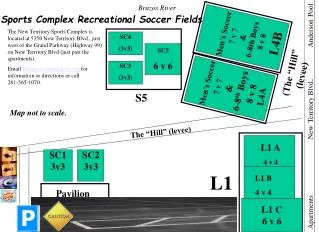
Vicinity/Segment Map Figure with protected area polygon overlaid on google map/Corpsmap. • Identify location and number of embankment sections, floodwalls, pump stations, major culverts / penetrations, and protected area # of closures. [levee – brown line, floodwall – black line, pump station or culvert – orange dot,
Geomorphology / Foundation Geology • Present typical foundation / subsurface conditions in longitudinal profile and or cross section.
Typical Sections • Embankments, floodwalls, major culverts and other pertinent features • Label height, crest/top width, slope angles, drainage features, seepage barriers/cut off walls, etc
Summarize Hydraulics • Frequency top of levee/floodwall or show on typical sections • Frequency toe of levee/floodwall or show on typical sections • Identify frequency of event that results in poor performance/history of problems • Summarize loading history – flood of record plus other major flood events
Performance History • On Segment Map show area/ reaches with major seepage, boils, instability, flood fighting, overtopping, erosion, etc. • Indicate % of height of the levee / floodwall/culvert at which problems start to occur. • May be able to capture some or all of this information on previous slide otherwise show it here
ICW Ratings • Include date of Inspection, date of Screening and who performed these tasks (AE/Corps/Others) • Short summary of ICW inspection and any issues noted
Review/Compare ICW Rating with LST Rating in Table format Highlight LST ratings that are M or U. Review of Assessment Ratings
Major Contributors to Overall Risk Rating • Focus discussion on selected items that were deemed Unsatisfactory and that are major contributors to the overall risk / rating. Include enough background data/documentation, and justification to make the case. Provide photos as additional slides that support the rating.
Example: Culverts/Closure • If multiple culverts/closures are associated with project, the logic behind which one was rated should be provided by the LST Facilitator • Embankment culvert selected and why • * What was used to assess the culvert? Existing condition, supplemental tool, etc… • Floodwall culvert selected and why • * What was used to assess the culvert? Existing condition, supplemental tool, etc…
Consequence Data Summary • Weighted Fatality Rate • Threatened Population without warning • Estimated Loss of Life without warning • Number of structures Inundated • Weighted economic damage factor • Economic Damages • Critical Infrastructure / Environments
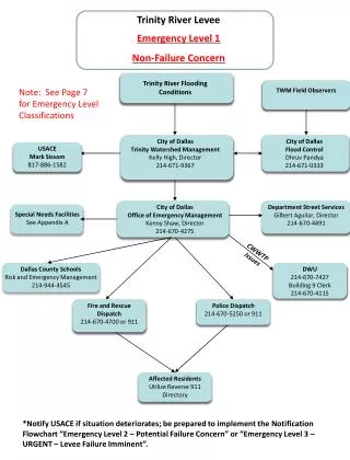
Emergency Preparedness • Evacuation Planning • Community Awareness • Flood Warning Effectiveness
Plot Results LOL and Economics • National Roll-up Only Slide
LSAC Rating Adjustments • National Rollup slide only • Reasons to adjust LSAC rating