Download
1 / 114
1.14k likes | 1.15k Views
Climate. Standards 5a, 6a and 6b. climate zone video. climate clips. CA climate zones. Climatogram clip. Vocabulary Ch. 21. Rain Shadow Effect 8. Arid 9. Deciduous 10. Tundra. Grassland Temperate Zone 3. Latitude 4. Windward Side 5. Topography 6. Ice Age.

E N D
Climate Standards 5a, 6a and 6b climate zone video climate clips CA climate zones Climatogram clip
Vocabulary Ch. 21 • Rain Shadow • Effect • 8. Arid • 9. Deciduous • 10. Tundra Grassland Temperate Zone 3. Latitude 4. Windward Side 5. Topography 6. Ice Age Due on June 6
Describe what you see happening in the straw when you squeeze the bottle. Be as detailed as possible.
climate & weather video Climate Zones Video
Weather is what is happening in the atmosphere now. Climate: The average weather for an area. (temperature & amount of precipitation)
3 climate zones based on latitude 60°N YL 30°N 30 °S 60°S
Climate The average weather of an area.
Climate is determined by the intensity of the solar energy and the amount of precipitation an area receives.
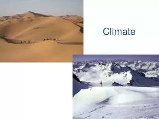
The three main climates are: • Tropical Climate (30º N to 30º S) usually hot & wet. • Temperate Climate (30ºN to 60ºN & 30ºS to 60ºS) hot summers and cold winters. • Polar Climate (60ºN to 90ºN & 60ºS to 90ºS) usually cold.
Each of the main climates can be further divided by being wet or dry zones.
Tropical Rainforest on the equator – rain everyday and usually 75° F to 85° Feveryday (summer and winter).
Temperate Rainforest: around 60° N – rain almost every day, but cooler winters than summers
Desert at 30º N – very little rain. Hot days, cool nights. Hotter in summer than winter.
Grasslands/Savannah: In between wet and dry climates in temperate zone. Hot summers, cool winters. Not enough rain for trees.
Polar Zone: around 70° N – not much rain. Winters much colder than summer. No trees, ground permanently frozen (permafrost).
Polar Zone: around 70° N – not much rain. Winters much colder than summer
Climate is determined by: • 1. LATITUDE and global winds • 2. ELEVATION • 3. TOPOGRAPHY • 4. PROXIMITY TO LARGE BODIES OF WATER • 5. PROXIMITY TO WARM OR COLD OCEAN CURRENTS
LATITUDE • Horizontal line parallel to the equator. • 90º = North or south pole • 0º = Equator • Colder as you increase latitude and warmer as you decrease latitude
LATITUDE 1º Celsius temperature change for every 2º change in latitude.
North pole, 90°N Equator, 0° Latitude measures how far north or south you are from the equator! South pole, 90°S
= Barrow, Alaska = Seattle, Washington = Yorba Linda, CA = Singapore, Singapore
41ºN 38ºN 32ºN
Which California city would likely be warmer in the summer?Campo 36ºN or Yreka 41.7ºNWhich California city would likely be cooler in the winter? Campo 36ºN or Yreka 41.7ºN
42 LATITUDE Using latitude, which spot should be warmest? A 40 38 B 36 34 32 C
42 LATITUDE Using latitude, which spot should be coldest? A 40 38 B 36 34 32 C
ELEVATION • Means height above sea level. • Greater the elevation, cooler the temperature.
ELEVATION • 8º Celsius temperature change for every 1000 meter gain in elevation.
ELEVATION 4 3 2 1
TOPOGRAPHY • Means the shape of the land • Examples: mountains, plains, valleys
Proximity to water • Water heats up slower than land, so if you live close to water your temperature changes less than if you live far from water • Compare YLHS to Newport
Proximity to warm or cold currents • Warm currents keep the land warm (Gulf Stream keeps Europe warm) • Cold currents keep the land cooler (like the California Current)
Weather vs. Climate • Weather: the atmospheric conditions for a particular place, on a particular day • Small spatial scale • Instantaneous on time scale • Climate: the long-term pattern of atmospheric conditions • Spatial scale local, regional, or global • Takes several years to understand
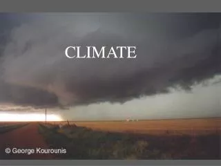
Weather releases a tremendous amount of energy • Evaporation • Tornados and hurricanes • Where does all this energy come from?
Weather releases a tremendous amount of energy • Evaporation • Tornados and hurricanes • Where does all this energy come from? SUN