Download
1 / 22
220 likes | 365 Views
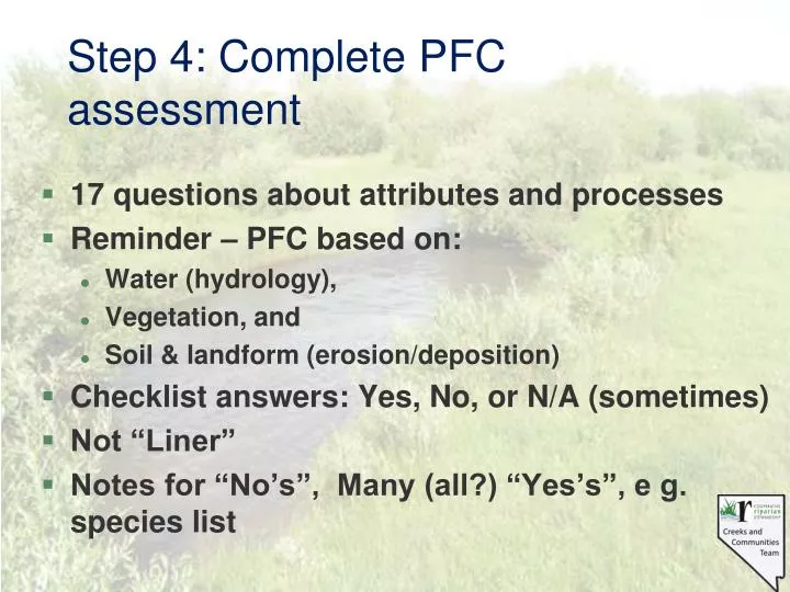
Step 4: Complete PFC assessment. 17 questions about attributes and processes Reminder – PFC based on: Water (hydrology), Vegetation, and Soil & landform (erosion/deposition) Checklist answers: Yes, No, or N/A (sometimes) Not “Liner”

E N D
Step 4: Complete PFC assessment • 17 questions about attributes and processes • Reminder – PFC based on: • Water (hydrology), • Vegetation, and • Soil & landform (erosion/deposition) • Checklist answers: Yes, No, or N/A (sometimes) • Not “Liner” • Notes for “No’s”, Many (all?) “Yes’s”, e g. species list
Floodplain • Level area near a stream channel • Constructed by the stream • In the present climate • Flooded during moderate & high flow events • Should not be confused with terraces (abandoned floodplains)(adapted from Leopold 1994) Valley flat Abandoned floodplain or terrace Hill slope Floodplain Channel Item #1: Floodplain inundation
Floodplain – Geologic feature being formed by the river in its present condition and climate
Bankfull Concept Information Forest Service Stream Systems Technology Center (Stream Team) website for on-line training videos, can order CDs and DVDs: www.stream.fs.fed.us • Western U.S. • Northeastern U.S. (4 CDs) • Forested Streams Eastern U.S. http://www.stream.fs.fed.us/publications/bankfull_west.html
Field Observations • Build a case based on physical evidence • Series of depositional features at consistent elevations with similar substrate and veg components • Point bars at inside of meander bends, • Point bars often not well developed with low sinuosity, • Discontinuous alternating longitudinal bars parallel to the channel often most dependable indicator • Broad valley floors are almost always above bankfull Bankfull Indicators (Moody et al. 2003, Odem and Moody 1999)
Floods Terrace Bankfull
1.) Floodplain above bankfull is inundated in “relatively frequent” events Yes BANKFULL NO
2.) Where beaver dams are present they are active and stable YES BEAVER DAM
2) Where beaver dams are present, they are active and stable • Examples of visual indicators • Dam construction material • Dams keyed into streambanks • Breaches
3.) Sinuosity, width/depth ratio, and gradient are in balance with the landscape setting (i.e., landform, geology, and bioclimatic region) NO NEW CHANNEL OLD CHANNEL
3) Sinuosity, width/depth ratio, and gradient are in balance with the landscape setting (i.e., landform, geology, and bioclimatic region) • Examples of visual indicators • Aerial photos help with sinuosity
3.) Sinuosity, width/depth ratio, and gradient are in balance with the landscape setting (i.e., landform, geology, and bioclimatic region) YES
4.) Riparian zone is widening or has achieved potential extent. NO YES
4) Riparian-wetland area is widening or has achieved potential extent • Examples of visual indicators • Riparian-wetland community types expanded to valley edge • Stream narrowed • Upland plants dying or dead • Depositions being captured
5.) Upland watershed is not contributing to riparian-wetland degradation NO? YES
5) Upland watershed is not contributing to riparian degradation Belgo Cr BC 1996 Trapping Cr BC 1996