Download
1 / 23
250 likes | 535 Views
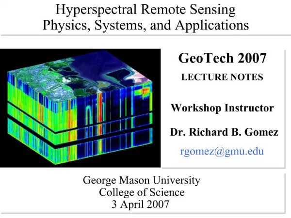
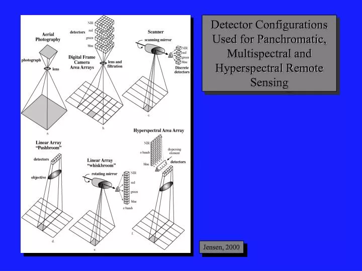
Detector Configurations Used for Panchromatic, Multispectral and Hyperspectral Remote Sensing. Jensen, 2000. GOES (Geostationary Operational Environmental Satellite). GOES Bands: Band Wavelength Range (mum) Spatial Resolution

E N D
Detector Configurations Used for Panchromatic, Multispectral and Hyperspectral Remote Sensing Jensen, 2000
GOES (Geostationary Operational Environmental Satellite) GOES Bands: Band Wavelength Range (mum) Spatial Resolution 1 0.52 - 0.72 (visible) 1 km 2 3.78 - 4.03 (shortwave IR) 4 km 3 6.47 - 7.02 (upper level water vapor) 4 km 4 10.2 - 11.2 (thermal IR) 4 km 5 11.5 - 12.5 (thermal IR) 4 km
GOES East and West Coverage GOES East Infrared August 25, 1989 GOES East Visible August 25, 1989 Jensen, 2000
GOES East Infrared GOES East Visible GOES East August 25, 1989 GOES East Water Vapor Jensen, 2000
Mission Characteristics: Orbit Type :Sun Synchronous at 705 km Equator Crossing: Noon +20 min, descending Orbital Period: 99 minutes Swath Width: 2,801 km LAC/HRPT (58.3 degrees) Swath Width: 1,502 km GAC (45 degrees) Spatial Resolution: 1.1 km LAC, 4.5 km GAC Real-Time Data Rate: 665 kbps Revisit Time: 1 day Digitization: 10 bits SeaWiFS Instrument Bands: Band Wavelength 1 402-422 nm 2 433-453 nm 3 480-500 nm 4 500-520 nm 5 545-565 nm 6 660-680 nm 7 745-785 nm 8 845-885 nm Surface ocean color sensor
Sea surface productivity Ocean color sensing from SeaWifs
Spectral and Spatial Resolution of the Landsat Multispectral Scanner (MSS), Landsat 4 and 5 Thematic Mapper (TM), Landsat 7 Enhanced Thematic Mapper Plus (ETM+), SPOT 1, 2, and 3 High Resolution Visible (HRV), and SPOT 4 High Resolution Visible Infrared (HRVIR) Sensor Systems Jensen, 2000
Chronological Launch and Retirement History of the Landsat Satellite Series Jensen, 2000
Landsat 7 Image of Palm Spring, CA 30 x 30 m (bands 4,3,2 = RGB) Jensen, 2000
Landsat 7 Image of Palm Spring, CA 30 x 30 m (bands 7,4,2 = RGB) Jensen, 2000
Chronological Launch History of the SPOT Satellites Jensen, 2000
Advanced Very High Resolution Radiometer (AVHRR) Bandwidths Jensen, 2000
Advanced Very High Resolution Radiometer (AVHRR) Imagery Jensen, 2000
Advanced Very High Resolution Radiometer (AVHRR) Mosaic of the Conterminous United States Jensen, 2000
Earth Observing System - Terra Instruments ASTER - Advanced Spaceborne Thermal Emission and Reflection Radiometer CERES - Clouds and the Earth’s Radiant Energy System MISR - Multi-angle Imaging Spectroradiometer MODIS - Moderate-resolution Imaging Spectroradiometer MOPITT - Measurement of Pollution in the Troposphere Jensen, 2000
Earth Observing System Measurements Discipline Measurement EOS-AM Instruments Atmosphere Cloud Properties MODIS, MISR, ASTER Radiative Energy Fluxes CERES, MODIS, MISR Precipitation Tropospheric Chemistry MOPITT Stratospheric Chemistry Aerosol Properties MISR, MODIS Atmospheric Temperature MODIS Atmospheric Humidity MODIS Lightning Jensen, 2000
Earth Observing System Measurements Discipline Measurement EOS-AM Instruments Land Land Cover/Land Use Change MODIS, MISR, ASTER Vegetation Dynamics MODIS, MISR, ASTER Surface Temperature MODIS, ASTER Fire Occurrence MODIS, ASTER Volcanic Effects MODIS, MISR, ASTER Surface Wetness Jensen, 2000
Earth Observing System Measurements Discipline Measurement EOS-AM Instruments Ocean Surface Temperature MODIS Phytoplankton MODIS, MISR Dissolved Organic Matter MODIS, MISR Surface Wind Fields Ocean Surface Topography Cryosphere Land Ice Change ASTER Sea Ice MODIS, ASTER Snow Cover MODIS, ASTER Solar Radiation Total Solar Radiation Ultraviolet Spectral Irradiance
Earth Observing System - Terra Instruments MODIS - Moderate-resolution Imaging Spectroradiometer Spectral Range 0.4 - 14.4 mm Spatial Coverage+55˚, 2330 km swath Spatial Resolution 250 m (2 bands), 500 m (5 bands), 1000 m (29 bands) ASTER - Advanced Spaceborne Thermal Emission and Reflection Radiometer Spectral Range VNIR 0.4 - 14.4 mm, SWIR 1.6 - 2.5 mm, TIR 8 - 12 mm Spatial Resolution 15 m (VNIR : 3 bands) 30 m (SWIR: 6 bands) 90 m (TIR: 5 bands) Jensen, 2000
IKONOS Panchromatic Images of Washington, DC Jensen, 2000 1 x 1 m spatial resolution
IKONOS Imagery of Columbia, SC Obtained on October 28, 2000 Panchromatic 1 x 1 m Pan-sharpened multispectral 4 x 4 m
Multi-angle Imaging Spectroradiometer (MISR) Onboard Terra Jensen, 2000