Download
1 / 58
590 likes | 814 Views
Cloud Formation. Formation of clouds requires a mechanism that results in the uplift of air. First, recall. Adiabatic process - process in which temperature changes but heat energy is not added or removed. p . ∆V = - Cv . ∆T. ∆ H - Change in heat p - pressure ∆V - Volume Change

E N D
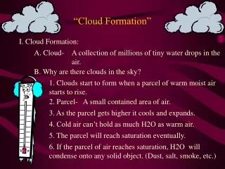
Cloud Formation Formation of clouds requires a mechanism that results in the uplift of air.
Adiabatic process - process in which temperature changes but heat energy is not added or removed.
p . ∆V = - Cv . ∆T ∆ H - Change in heat p - pressure ∆V - Volume Change Cv - Specific heat ∆ T - Temperature Change Adiabatic process - process in which temperature changes but heat energy is not added or removed. For adiabatic systems gases warm as they contract. For adiabatic systems gases cool as they expand.
p . ∆V = - Cv . ∆T ∆ H - Change in heat p - pressure ∆V - Volume Change Cv - Specific heat ∆ T - Temperature Change Adiabatic process - process in which temperature changes but heat energy is not added or removed. For adiabatic systems gases warm as they contract. For adiabatic systems gases cool as they expand.
p . ∆V = - Cv . ∆T For adiabatic systems gases warm as they contract. For adiabatic systems gases cool as they expand.
dry adiabatic lapse rate (DALR) – rate at which a rising parcel of dry (unsaturated) air cools. about 1oC/100m (5.5oF/1000 feet) Lifting Condensation level (LCL) – the height at which a rising parcel of air undergoes condensation or deposition. Saturated adiabatic lapse rate (SALR) – rate at which a rising parcel of wet (saturated) air cools. about 0.5oC/100m (3.3oF/1000 feet) Environmental Lapse Rate (ELR) - rate at temperature in the troposphere decreases with height.
Mechanisms That Lift Air 1) Orographic Lifting 2) Frontal Lifting 3) Convergence 4) Convection
Mechanisms That Lift Air • Orographic Lifting - the forcing of air above a mountain barrier. -air flowing toward a topographic high (hill or mountain) will be deflected over the barrier and displaced upward. -downwind of the mountain, air descends the slope and warms by compression Rain Shadow - an area on the downwind side of a mountain barrier having relatively low precipitation.
Mechanisms That Lift Air Rain Shadow Deserts Nevada Gobi Desert, China
Mechanisms That Lift Air 2) Frontal lifting - displacement of one air mass over another. Front - A transition zone between two dissimilar air masses with differing temperatures and/or moisture. Results in clouds in two ways.
Mechanisms That Lift Air 2) Frontal lifting - displacement of one air mass over another. Front - A transition zone between two dissimilar air masses with differing temperatures and/or moisture. Results in clouds in two ways. a) Cold Front - cold air mass advancing toward a warmer air mass. The denser cold air displaces the lighter warm air ahead of it. Results on cumulonimbus clouds.
Mechanisms That Lift Air 2) Frontal lifting - displacement of one air mass over another. b) Warm Front - warm air mass advancing toward a cooler air mass. The warm air rides over the wedge of cold air as if it is rising over a mountain barrier. Overrunning - warm air flows upward over the cold air. Results in nimbostratus clouds.
Mechanisms That Lift Air Pressure differences in the atmosphere set air in motion causing winds. When there is a center of low pressure, winds tend to converge toward the center from all directions 3) Convergence - horizontal movement of air toward a center of low pressure. 4) Convection - heating air near the surface causes the air to become less dense and rise upward.
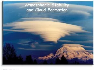
Stability Once given an initial boost air may continue to rise. Other times it may resist rising Stable air - resists rising. Unstable air - air that will continue to rise once given it initial boost. Stability is related to density low density air tends to rise upward. high density air tends to sink. Warmer air is less dense and will tend to rise Cooler air is more dense and will resist rising
Stability If a parcel of rising air cools at a rate that makes it colder than its surrounding air, it will become relatively dense - this inhibits rising. If the lifted air cools more slowly than its surrounding air, it will become warm and will continue to rise upward. The cooling of air is governed by the DALR or the SALR
Stability Absolutely unstable Absolutely stable Conditionally unstable
7oC 8.5oC 8oC 9oC 9oC 9.5oC 10oC 10oC 400 300 200 100 0 Absolutely Unstable Air 5.5oC 7oC Height (m) 8.5oC 10oC ELR (1.5) DALR (1.0) SALR (0.5) oC/100m
Stability Absolutely Unstable Air Once lifted it continues rise upward Rule 1: Whenever the ELR exceeds the DALR, the air is absolutely unstable and will continue to rise once lifted, regardless of whether it is saturated or not.
8oC 9oC 9oC 9.5oC 10oC 10oC 400 300 200 100 0 Absolutely Stable Air 9.1oC 9.4oC Height (m) 9.7oC 10oC ELR (0.3) DALR (1.0) SALR (0.5) oC/100m
Stability Absolutely Stable Air Lifted air that has a negative buoyancy and sinks back down to its initial position. Rule 2: Whenever the ELR is less than the SALR, the air is absolutely stable and will resist lifting, regardless whether it is saturated or not.
7oC 8.5oC 8oC 9oC 9oC 9.5oC 10oC 10oC Conditionally Unstable Air 400 300 200 100 0 8.1oC 8.8oC Height (m) 9.3oC 10oC ELR (0.7) DALR (1.0) SALR (0.5) oC/100m
Stability Conditionally Unstable Air The tendency of the air to rise depends on whether it is saturated or not. Rule 3: Whenever the ELR is between the DALR and the SALR, the air is conditionally unstable and whether it rise or sinks depends on whether it becomes saturated or not.
Composition of Clouds Water droplets Ice crystals Air Air makes up the greatest mass of a cloud!
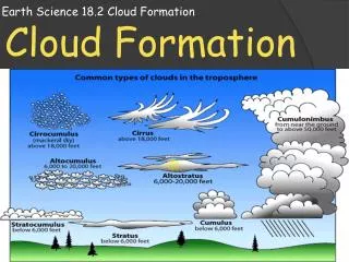
Cloud Types General Characteristics of Clouds • Assume a variety of shapes • Most occur within the troposphere • Contain a combination of liquid droplets and ice crystals
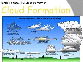
Cloud Types First widely accepted system for classification of clouds: Luke Howard (1803) - English naturalist (4 basic categories) • Cirrus (Latin for curl) - thin wispy clouds of ice. • Stratus (Latin for layer) - layered clouds. • Cumulus (Latin for heap) - clouds having vertical development • Nimbus (Latin for rain) - rain clouds Today we use a modified version of Howard’s classification scheme.
Cloud Types Ten major cloud types grouped by their shape and height • High Clouds > 6000m Cirrus Cirrostratus Cirrocumulus • Middle Clouds 2000 - 6000m Altostratus Altocumulus
Cloud Types Ten major cloud types grouped by their shape and height C. Low Clouds <2000 m Stratus Stratocumulus Nimbostratus D. Clouds with vertical development Cumulus Cumulonimbus
Cloud Types • High Clouds above 6000m 1900 feet) Almost always composed of ice Temperatures <-35oC • Cirrus (Ci) • wispy aggregates of ice crystals • ~1.5 km thick Fall streaks - ice crystals in cirrus clouds fall and descend below the cloud. Usually form in fair weather.
Cloud Types • High Clouds b. Cirrostratus (Cs) • Composed entirely of ice • Moon or sun can be viewed through these clouds but will have a whitish appearance • Sometimes light from the sun or moon will be bent by the ice and create a halo around the sun or moon. • Cirrocumulus (Cc) • Ice crystals arranged in rows of individual puffy clouds • Rows form from wind shear - wind changing speed or direction. • Mackeral sky
Cloud Types B. Middle Clouds 2000-6000 feet composed of liquid droplets alto - middle a. altostratus (As) - similar to cirrostratus but at middle level in the atmosphere. - composed of liquid - scatter back a large percentage of incoming solar radiation, reducing the sunlight reaching the surface. - No shadows - No halo as in cirrostratus
Cloud Types B. Middle Clouds b. altocumulus (Ac) - layered clouds that form long bands of puffs. - often gray in color - mostly liquid Usually form by convection in unstable air, as a cold front approaches.
Cloud Types C. Low Clouds cloud base below 2000m a. stratus (St) - layered clouds. - form from extensive areas of unstable air - can exceed several states in extent b. nimbostratus (Ns) - low, layered clouds that yield precipitation. - Usually light steady precipitation