Download
1 / 50
510 likes | 659 Views
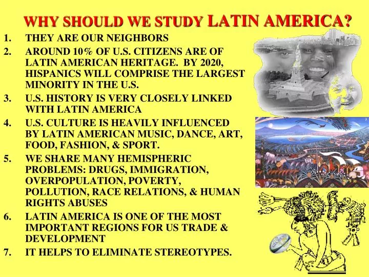
THEY ARE OUR NEIGHBORS AROUND 10% OF U.S. CITIZENS ARE OF LATIN AMERICAN HERITAGE. BY 2020, HISPANICS WILL COMPRISE THE LARGEST MINORITY IN THE U.S. U.S. HISTORY IS VERY CLOSELY LINKED WITH LATIN AMERICA

E N D
THEY ARE OUR NEIGHBORS AROUND 10% OF U.S. CITIZENS ARE OF LATIN AMERICAN HERITAGE. BY 2020, HISPANICS WILL COMPRISE THE LARGEST MINORITY IN THE U.S. U.S. HISTORY IS VERY CLOSELY LINKED WITH LATIN AMERICA U.S. CULTURE IS HEAVILY INFLUENCED BY LATIN AMERICAN MUSIC, DANCE, ART, FOOD, FASHION, & SPORT. WE SHARE MANY HEMISPHERIC PROBLEMS: DRUGS, IMMIGRATION, OVERPOPULATION, POVERTY, POLLUTION, RACE RELATIONS, & HUMAN RIGHTS ABUSES LATIN AMERICA IS ONE OF THE MOST IMPORTANT REGIONS FOR US TRADE & DEVELOPMENT IT HELPS TO ELIMINATE STEREOTYPES. WHY SHOULD WE STUDY LATIN AMERICA?
SSWGS7 LATIN AMERICA
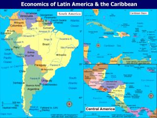
PHYSICAL NOTES LATIN AMERICAINCLUDES: • MEXICO
THE 12 COUNTRIES OF SOUTH AMERICA AND 1 DEPENDENCY – FRENCH GUIANA
MIDDLE AMERICA (MEXICO & CENTRAL AMERICA) • VERY MOUNTAINOUS • CLIMATE AFFECTED MOST BY ELEVATION • MEXICO CALLED “COUNTRY OF MOUNTAINS” • OVER 100 ACTIVE VOLCANOES ON PACIFIC COAST • CARIBBEAN COASTS = LOWLANDS
MEXICO • “COUNTRY OF MOUNTAINS” • 2 CHAINS • SIERRA MADRE OCCIDENTAL (WEST) • SIERRA MADRE ORIENTAL (EAST) • CENTRAL PLATEAU IN THE CENTER • MOST IMPORTANT REGION • MAJORITY OF POPULATION LIVES HERE (GOOD FARMLAND) • GEOLOGICALLY UNSTABLE (MANY EARTHQUAKES & VOLCANOES) • GOOD CLIMATE (LOTS OF RAINFALL IN THE SOUTH)
COASTAL REGIONS • North Pacific Coast: Dry, hot, thinly populated Good farmland due to irrigation from rivers (Colorado River, Sonora River, Yaqui River) • South Pacific Coast: Tourism (Acapulco, Mazatlan, Puerto Vallarta) • Gulf Coastal Plain: Deposits of Petroleum & Natural Gas • Yucatan Peninsula • Flat Land • Water passes through limestone & forms underground streams (this has carved out underground caverns)
CENTRAL AMERICA CONSISTS OF 7 COUNTRIES: • GUATEMALA • EL SALVADOR • COSTA RICA • PANAMA • NICARAGUA • BELIZE • HONDURAS
CARIBBEAN • CHAIN OF ISLANDS @ 2000 MILES LONG (ARCHIPELAGO) • LARGEST ISLANDS: • CUBA • HISPANIOLA (HAITI & DOMINICAN REP.) • PUERTO RICO • JAMAICA • 3 GROUPS OF ISLANDS • BAHAMAS • GREATER ANTILLES • LESSER ANTILLES • ISLANDS FORMED DIFFERENTLY • BAHAMAS – CAYS (KEEZ) LOW LYING CORAL ISLANDS • GREATER ANTILLES – TOPS OF UNDERWATER MOUNTAINS • LESSER ANTILLES – VOLCANIC ACTIVITY
SOUTH AMERICA • VERY SIMILAR TO NORTH AMERICA • WEST – HIGH, RUGGED MOUNTAINS (ANDES) • CENTRAL – PLAINS (AMAZON BASIN AND PAMPAS) • EAST –LOW, ROUNDED MOUNTAINS (BRAZILIAN HIGHLANDS)
Similarities-Climate • Marine West Coast (Chile & W. Argentina) • Western Coast climate • Promotes outside activities • Mild climate (summer & winter) • SIMILIAR TO OREGON & WASHINGTON
DRY–HUMID SUBTROPICAL • PAMPAS- • MILD TO WARM TEMPS (SEASONAL RAIN) • SAVANNAS & GRASSLANDS-LOCATED IN BRAZIL, COLOMBIA,& ARGENTINA
VERTICAL/HIGHLAND • COOLER TEMPS • FEWER • PEOPLE • CROPS • RESOURCES
Rainforest • High temperatures • Rainfall throughout the year
POPULATION • MORE PEOPLE LIVE NEAR THE COASTS, RATHER THAN IN THE INTERIOR • THERE ARE TWICE AS MANY PEOPLE AS IN THE UNITED STATES • ½ OF THEM LIVE IN CITIES
HISTORY • LAND WAS CONQUERED BY THE SPANISH • MOST HAVE POLITICAL TURMOIL • THERE ARE MANY UNSTABLE GOVERNMENTS, MILITARY LEADERS, & REVOLUTIONS • THERE HAVE BEEN MANY coup d’etat • MOST COUNTRIES ARE STRIVING FOR DEMOCRCACY, EXCEPT FOR CUBA (FIDEL CASTRO STILL HOLDS ON TO COMMUNISM)
LANGUAGE, RELIGION, & ETC. • MOST COUNTRIES SPEAK SPANISH. OTHERS SPEAK ENGLISH (JAMAICA, GUYANA, & BELIZE), FRENCH (HAITI, & MARTINIQUE) AND PORTUGUESE (BRAZIL) • 82% ARE ROMAN CATHOLIC. OTHERS ARE PROTESTANT & SOME NON-CHRISTIANS • FAMILY IS THE KEY TO LATIN AMERICAN LIFE
The ancient Roman Empire spoke Latin from 100B.C.-400 A.D. • They controlled what is modern-day France, Spain, and Portugal • After the fall of the empire, Latin turned into French in France, Spanish in Spain, Portuguese in Portugal • In the 1500’s A.D., Spain conquered the “new world” in South America • They forced the people to learn Spanish, a language based on Latin • Today, the areas where Spain, Portugal, and France (but mainly Spain) conquered is called “Latin” America
History - continued • The spoken languages are the result of the conquistadors. • Legacy of slavery – from 1600-1800 A.D. more African slaves were taken to Brazil - 3.6 million than to America – 650,000 • So Brazil’s population is highly diverse, with a large percentage of African Brazilians • 1800’s – Revolutions all over for independence against Spanish leaders took place • Today – most countries are democratic with lingering dictatorships
Conquistador – Spanish word for conqueror Cultural Convergence– merging of cultures What countries does France still own? France still owns French Guiana, Martinique, Guadeloupe
ECONOMIC ACTIVITY • MOST COUNTRIES ARE STILL IN THE DEVELOPING STATE • MOST ECONOMIES ARE BASED UPON AGRICULTURE. CASH CROPS INCLUDE: COFFEE, BANANAS, SUGARCANE, COCOA (CACAO) • LATIFUNDIA – LARGE ESTATES OWNED BY FAMILIES OR CORPORATIONS • MINIFUNDIA – SMALLER FARMS THAT PRODUCE FOR THE FAMILY AND SELL IN THE MARKET • THE MOST INDUSTRIALIZED COUNTRIES ARE MEXICO (MOTOR VEHICLES, ELECTRIC GOODS) & BRAZIL (IRON, STEEL, AUTOMOBILES, TEXTILES, MACHINERY) • INDUSTRIAL DEVELOPMENT IS SLOW BECAUSE OF LACK OF CAPITAL, SKILLED WORKERS & RAW MATERIALS
MEXICOANCIENT CULTURE OF MEXICO AZTECS • CAPITOL CITY OF TENOCHTITLAN – NOW MEXICO CITY • AT THE TIME, WAS ONE OF THE LARGEST CITIES IN THE WORLD • THE AZTECS WERE DESTROYED BY THE SPANISH CONQUISTADORS (1521)
SPANISH CULTURE OF MEXICO • 4 SOCIAL CLASSES: • PENINSULARES (SPANISH – BORN) (IBERIAN PENINSULA) • CRIOLLOS – PEOPLE OF SPANISH ANCESTRY BORN IN THE NEW WORLD • MESTIZOS – PART SPANISH, PART INDIAN • INDIAN • HACIENDAS – MEXICAN PLANTATIONS • CLASS STRUCTURE LASTED 300 YEARS • UNTIL 1821, MEXICO WAS A SPANISH COLONY • GAINED INDEPENDENCE IN 1821 • IN 1920 – BECAME A DEMOCRACY AFTER 10 YEARS OF CIVIL WAR
MEXICO TODAY • OFFICIAL LANGUAGE – SPANISH • MOST MEXICANS ARE ROMAN CATHOLIC • MAJORITY OF POPULATION LIVES IN URBAN AREAS • MEXICO CITY IS THE LARGEST CITY IN THE WORLD • FAMILY IS IMPORTANT TO THE MEXICAN PEOPLE • ECONOMICS – MOST IMPORTANT INDUSTRIES IN MEXICO ARE: • PETROLEUM – 4TH LARGEST PRODUCER IN THE WORLD • TOURISM – CALLED THE “SMOKELESS INDUSTRY”
CENTRAL AMERICA & THE CARIBBEAN • 4 MAIN ETHNIC GROUPS • INDIANS • EUROPEANS – 2ND LONGEST HISTORY • MESTIZOS • AFRICAN – AMERICANS • 6 OF THE 7 COUNTRIES SPEAK SPANISH – BELIZE SPEAKS ENGLISH • 2 ECONOMIC GROUPS • SMALL WEALTHY CLASS (EUROPEANS & MESTIZOS) • POOR CLASSES (INDIANS & AFRICAN – AMERICANS)
CARIBBEAN • ETHNICALLY, MOSTLY AFRICAN (DESCENDANTS OF SLAVES OF SUGAR PLANTATIONS) • ECONOMIC ACTIVITY – SUGAR CANE (RUM IS A BY-PRODUCT) & TOURISM
PUERTO RICO • COMMONWEALTH OF THE UNITED STATES • ELECTS ITS OWN GOVERNOR & LEGISLATIVE BODY • PEOPLE HAVE FULL U.S. CITIZENSHIP • DO NOT PAY FEDERAL INCOME TAX • CANNOT VOTE IN PRESIDENTIAL ELECTIONS (NO TAXATION WITHOUT REPRESENTATION) • CAN ENTER OR LEAVE ANY PART OF THE UNITED STATES AT WILL
AZTECS • LIVED IN MEXICO’S CENTRAL PLATEAU • FEARED & HATED BY OTHERS IN MEXICO • WARLIKE, DEFEATED MORE “SETTLED” PEOPLE & FORCED THEM TO PAY TAXES • BECAME SKILLED BUILDERS • BUILT CAPITOL CITY OF TENOCHTITLAN IN THE MIDDLE OF A LAKE BED • PYRAMIDS • WORSHIPPED MANY GODS • SUN GOD – THOUGHT IT WOULD WEAKEN AND DIE IF IT WAS NOT FED BLOOD & HUMAN HEARTS • ENGAGED IN WARFARE TO PROVIDE SACRIFICES
MAYA • LIVED MOSTLY IN CENTRAL AMERICA, YUCATAN PENINSULA • PRACTICED SLASH & BURN AGRICULTURE • MANY SCIENTIFIC & ARTISTIC ACHIEVEMENTS • CALENDAR • USE OF ZERO IN MATH (NOT KNOWN TO EUROPEANS) • DEVELOPED WRITTEN LANGUAGE • FOR REASONS UNKNOWN THEY BEGAN TO ABANDON MOST OF THEIR CITIES AROUND 800 – 900 A.D.
INCAS • INCAN EMPIRE LASTED APPROX. 100 YEARS • INCLUDED PARTS OF 5 PRESENT – DAY SOUTH AMERICANS COUNTRIES • ADVANCED METHODS OF AGRICULTURE: • IRRIGATION • FERTILIZERS • TERRACED FARMING • VERY RELIGIOUS • ENGINEERING BUILT STONE HIGHWAYS & SUSPENSION BRIDGES FOR TRANSPORTING GOODS • STRONG COMPLEX GOVERNMENT • FORCED POPULATION TO SAVE FOOD IN CASE OF FAMINE • TOOK CENSUS WITHOUT A WRITING SYSTEM • KEPT RECORDS BY TYING KNOTS IN A ROPE DEVICE CALLED A “GUIPU” (QUIPU)
Where would you expect to find tectonic plate boundaries in Latin America? Whenever a tectonic plate smashes into another one, usually a mountain range forms. So the west coast, where the Andes Mountain Range is, is the tectonic plate fault line. Based on the map, why do you think engineers would have chosen Panama for a canal? Because it is the narrowest point between the two continents and they wouldn’t have to dig as far.
Tropical Storm – storm with winds at least 39 mph; Hurricane – winds at least 74 mph, and in cyclone pattern; Southern Oscillation– Atmospheric component of the El Nino / La Nina cycle. High pressure vs low pressure areas that circulate the Pacific Ocean El Nino – ocean current in the Pacific Ocean that warms the cost of Peru and causes floods and droughts other places in the world. Would you expect Bolivia to be more strongly affected by hurricanes or by El Nino? Probably El Nino because El Nino begins off the coast there and causes hurricanes in other parts of the world.
Mestizo – native American and European descent Mulatto – European and African
Based on climate and topography, how would you explain the distribution of economic activities in Latin America? The people of the Amazon Basin are mainly subsistence farmers due to the poor soil and wet climate. Most manufacturing and trade takes place near the coast because of proximity to sea routes.
South America – 3 Regions • Northern Tropics - Characterized by warm tropical weather, rain forests, and coastal plains • Andean Countries - Characterized by coastal plains and highland mountains • Southern Grassland Countries - Many different characteristics with river system that connects them all
Latin America • Regions • South America • Central America • Spanish speaking, Portuguese and French
Andean Countries • Countries – Ecuador, Peru, Bolivia, Chile • People – mestizos native Indian peoples • Economic Activities – vertical trade, farming, lumber industry, fishing, manufacturing
Northern Tropics • Economic activity depends on elevation – • Countries – Guianas, Venezuela, Columbia • People – mulattoes and mestizos make up significant portion of population due to immigration and colonization • Economic Activities – OIL, sugar cane, rice, bauxite, coffee ---drugs.
Southern Grassland Countries • Estuary - rivers flow in an estuary and provide hydro-electric power to much of the countryside • Patagonia • Patagonia is a region located at the southern end of South America, shared by Argentina and Chile. • Economic Activities – Patagonia has burgeoning electronics industry; cold weather prevents factories from needing air conditioning
Answer these Questions What is the major mountain chain in South America? What is the primary land use? Name the largest country in south America…in Central America.
Some more questions Where do the majority of Mexicans live? What is the major mountain range in Mexico? What industry do the provinces located on the Gulf depend on?
Even more questions Describe the type of terrain, or physical geography, that some of the Caribbean Islands have? The Bahamas, a group of islands, are called this. What climate do all of the islands have? Name one country or ethnicity that many citizens of the Caribbean nations descended from?
Try these questions: What is El Nino? Name the main Mexican mountain range. How were the flat Caribbean Islands formed?
How about these: Name one of the three regions of Latin America. What is the major mountain range of South America? Name one the two “mixed” ethnicity that make up the people living in Latin America and state their origins.
For the TEST • Know vocabulary: mestizo, mulato, estuary, deforestation • Study the map of Middle & South America!!!! Know where the countries are located!!!