Download
1 / 31
310 likes | 488 Views
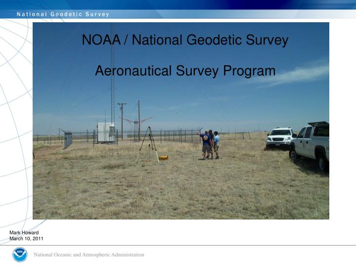
NGS role in supporting to FAA. NOAA / National Geodetic Survey Aeronautical Survey Program. Mark Howard March 10, 2011. Organization. National Oceanic and Atmospheric Administration National Ocean Service National Geodetic Survey Aeronautical Survey Program.

E N D
NGS role in supporting to FAA NOAA / National Geodetic Survey Aeronautical Survey Program Mark Howard March 10, 2011
Organization • National Oceanic and Atmospheric Administration • National Ocean Service • National Geodetic Survey • Aeronautical Survey Program NGS ASP provides products and services to FAA Aeronautical Information Services (AIS) through a NOAA/FAA inter-agency agreement
Aeronautical Survey ProgramSupporting the FAA • Provide positional, height, and orientation information to the FAA in support of the National Airspace System (NAS) and safe navigation • Review aeronautical survey deliverables submitted by 3rd party providers to the FAA • Develop survey standards, guidelines, tools, and models designed to assist surveyors conducting aeronautical surveys • Participate in studies of new and emerging technologies (LiDAR, Satellite Imagery, etc.) • Provide technical advice and assistance to data providers conducting aeronautical surveys in accordance with FAA standards
Standards and Guidance Manuals AC 150/5300-17B AC 150/5300-16A Airport Imagery Geodetic Control FAA 405 Runway Identification Ground Survey Rescinded (2006) AC 150/5300-18B
FAA Part 77 Surfaces FAA Part 77 Surfaces as depicted in FAA Spec. No. 405
Safety Critical Data for Instrument Procedure Development • Geodetic Control • Runway Points • Runway End, Displaced Threshold, Stopway End, TDZE, Airport Elevation, Runway Intersection, NAVAID Perp Points, ARP, Runway Profile Points • Runway/Stopway Length and Width • Displaced Threshold Length • Runway True Azimuth • Navigational Aids • Obstacles • Obstructing Areas • Obstruction Identification Surfaces
NGS Aeronautical Survey Process Survey Requirements Aerial Survey Geodetic Control Survey Preliminary Remote Sensing Survey / Data Mining Field Survey Final Remote Sensing Survey FAA Product
BM#1 PACS BM#2 SACS#1 HARN Airport SACS#2 Geodetic Control Network CORS FBN and BM ties must be observed simultaneously with both PACS • PACS and SACS monuments are positioned and tied to the National Spatial Reference System through GPS observations. Simplified Schematic
High-Resolution Imagery High-Resolution photography of the Airport collected for the entire study area. Imagery is used in the photogrammetric process for determining the height and position of obstacles and airport planimetric features.
NAVAID Survey All navigational aids within 10 nautical miles of the airport are tied to the established geodetic control
Obstruction Survey Numerous types of surveying techniques are used to determine the latitude, longitude, and height of obstructions within the FAA specified Obstruction Identification Surfaces
Photogrammetric Survey All survey information brought together into a Digital Photogrammetric Workstation
Digital Airport Obstruction Chart Products and Services FY08 • Geo-spatial file (ESRI shape file format) • Metadata • Geo-PDF • Data in UDDF format http://www.ngs.noaa.gov/AERO/eAOC/eAOC.htm
Summary • Primary role is to quality review safety critical data submitted to the FAA to ensure FAA standards and specifications are met (AC 150/5300-16, 17 & 18) • Provide technical advice and assistance in development / revision of standards and guidelines • Continue to develop models and tools designed to support surveyors conducting aeronautical surveys. • Continue to evaluate and research new technologies for increasing efficiency in mapping programs. • Conduct aeronautical surveys (as requested)
Possible incorrect positioning of runway end 30. Target out of plumb?
Runway Threshold 20 incorrectly positioned at inboard edge of 10 foot wide white paint bar. Point should be positioned on outboard edge of paint bar. . Refer to C.1.2.8.2
VORTAC OMMISION - VORTAC US Terminal Procedures diagram Photograph submitted. Positional Information not reported in submitted geo-spatial files
VOR/DME incorrectly submitted as VOR. DME positioned at VOR site is a monitor antenna
Submitted positions of Glide Slope Antenna does not match previously published positions. Airport Manager confirmed facility never moved
Feature #279 & #383 were incorrectly described as an ASR. This is actually a piece of equipment called AVIAN RADAR. It is used to track Migratory Birds & Bats.
Sign EL 205 Light Poles missing in submission, approximate EL 234. Obstacle Selection Criteria Light Poles (approximate EL 234) not reported Sign EL 205
Resources and Recommended Reading • FAA Airport Surveying – GIS Program • https://airports-gis.faa.gov/public/ • FAA Advisory Circulars (ACs) • FAA Forms / Templates / Tools • Online Help • News letters • A guide to Airport Surveys • Airports GIS Support Desk • 9-AWA-ARP-AirportSurveyingGIS@FAA.gov • Airports GIS Technical Support Desk (web site) • 202-580-7500 • FAASurveySupportDesk@cghtech.com
Resources and Recommended ReadingContinued • Aviation System Standards (AVN) • http://avn.faa.gov/index.asp?xml=index • Charts • Instrument Flight Procedures (IFP) Production Plan • U.S. Terminal Procedure Publications (TPPs) • Airport Diagrams • Airport/Facility Directory (A/FDs) • Airport Diagrams • NFD • Airport Master Records and Reports (5010) • http://www.gcr1.com/5010web/ • Aeronautical Information Publication (AIP) • http://www.faa.gov/air_traffic/publications/atpubs/AIP/aip.pdf
Resources and Recommended ReadingContinued • National Geodetic Survey • http://www.ngs.noaa.gov/ • NSRS • Data Sheets • Previous NGS Aeronautical Survey Data • Geodetic Tool Kit • CORS • OPUS • AC 150/5300-16 Deliverables (Examples) • http://www.ngs.noaa.gov/AERO/AirportsGIS/AC16/index.shtml