Download
1 / 51
510 likes | 624 Views
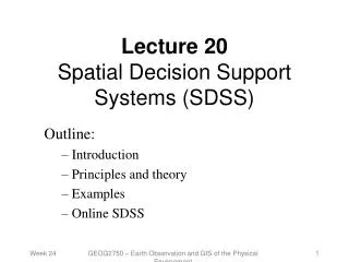
Institute for Environmental Studies. Spatial Decision Support Ron Janssen. Doelgerichte presentatie van informatie. De TGV. Napoleon’s campaign to Moscow. Poland 422000 Moscow 100.000 Poland 10000 Berezina 50000 28000 20° 28 oct. Tijd, plaats en omvang. Amoebe 2. Outline.

E N D
Institute for Environmental Studies Spatial Decision Support Ron Janssen
Napoleon’s campaign to Moscow Poland 422000 Moscow 100.000 Poland 10000 Berezina500002800020° 28 oct
Outline • Introduction to the plan area • Evaluation of management alternatives • A virtual environment of the alternatives • Design of management alternatives • Use of maps for evaluation
Policy alternatives • Modern fen meadow (current) water drainage to support agriculture open landscape food for meadow birds • Historical fen meadow educed drainage raise of water table negative impacts for agriculture opp. for some bird and plant species • Dynamic mire floods in winter permanent waterlogged soils no agriculture peat growth
Stakeholders and their interests • Agricultural organisationsConstant water levels , water quality Accessibility, Size Continuity and future perspectives for farms • Recreation (fisheries)Variation in landscapes Accessibility Water quality • Nature Conservation Organisations Flexible water levels, water quality Variation in landscapes also cultural/historic landscapes Corridors, Larger units of protected nature • Provincial/regional authorities Safety Water quality Water quantity
Results of evaluation3 alternatives x 10 criteria -> 30 evaluation maps Modern fen meadow Historical fen meadow Dynamic fen mire c1 c2 c.. c10
Three evaluation paths a1 a2 a3 a1 a2 a3 Path 3 SA c1 c2 c3 c4 c1 c2 c3 c4 Path 1 Path 2 MCA MCA a1 a2 a3 a1 a2 a3 SA
Evaluation maps a1 a2 a3 c1 c2 c3 c4 Total value maps a1 a2 a3
Aggregated impact table a1 a2 a3 a1 a2 a3 Spatial Aggregation c1 c2 c3 c4 c1 c2 c3 c4
Total ranking Weights Water quality Water quantity Biodiversity Climate change Socio- economic 0.44 0.43 0.35 0 Histor Dynam Modern
Ranking per policy objective Gewichten Water quality Water quantity Biodiversity Result 0.44 0.43 Climate change 0.35 Socio- economic Water quality 0.40 0.12 0.07 0.68 Water quantity 0.28 0.06 0.54 Biodiversity 0.46 0.42 0.71 Climate 0.48 0.18 0.58 0.55 Socio-economic 0.19 Histor Dyn Modern
Six Policy objectives Maximize totals 1.Maximize the natural value of the area, 2.Maximize the recreational value of the area, 3.Minimize cost of changing land use, Optimize spatial characteristics 4.Minimize fragmentation 5.Maximize cluster size, 6.Maximize compactness.
Spatial compactness Spatial compactness is defined as a combination of three indicators: fragmentation largest cluster compactness
How to use this system? • First round of policy design, scanning of alternatives • Preparation of land use and water management plans • Support of land use planners • Support of interactive processes
a. graph b. table c. text d. maps 2100 nat jaar ongewijzigd beheer 2100 nat jaar 2100 nat jaarwater direct afvoeren The future 1: Combine different types of information