Download
1 / 10
100 likes | 265 Views
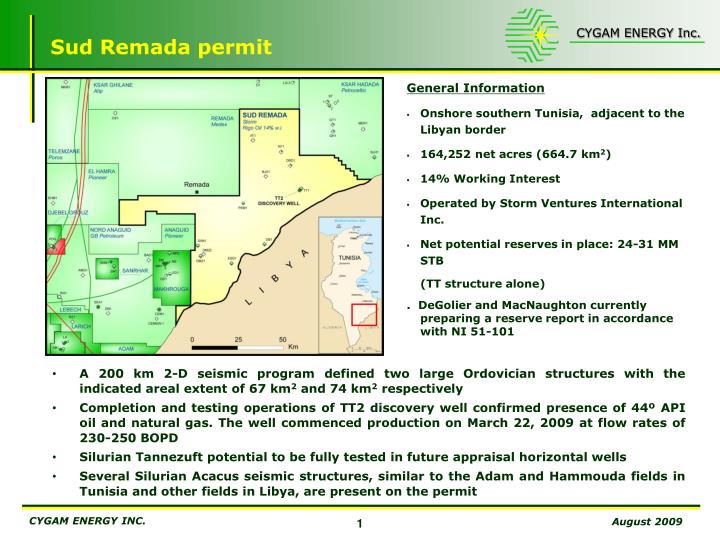
Sud Remada permit . A 200 km 2-D seismic program defined two large Ordovician structures with the indicated areal extent of 67 km 2 and 74 km 2 respectively

E N D
Sud Remada permit A 200 km 2-D seismic program defined two large Ordovician structures with the indicated areal extent of 67 km2 and 74 km2 respectively Completion and testing operations of TT2 discovery well confirmed presence of 44º APIoil and natural gas. The well commenced production on March 22, 2009 at flow rates of 230-250 BOPD Silurian Tannezuft potential to be fully tested in future appraisal horizontal wells Several Silurian Acacus seismic structures, similar to the Adam and Hammouda fields in Tunisia and other fields in Libya, are present on the permit • General Information • Onshore southern Tunisia, adjacent to the Libyan border • 164,252 net acres (664.7 km2) • 14% Working Interest • Operated by Storm Ventures International Inc. • Net potential reserves in place: 24-31 MM STB (TT structure alone) . DeGolier and MacNaughton currently preparing a reserve report in accordance with NI 51-101
Sud Remada permit TT-1 TT-2 GOC -1230m OWC -1269m C.I = 10 m 5 km 0 TT structure Structural closure: 110 km2 Gross reservoir: 98 m Area of oil pay: 67 km2 Oil pay: 50.5 m Area of gas pay: 35 km2 Gas pay: 7 m Independent Reserve Assessment: 170-220 MM STB in place 2009-2010 development plan includes: • One year (or up to 90,000 bbls) earlyproduction testing • Acquisition of 3D seismic on TT structure in late 2009 – early 2010 • Drilling of two appraisal wells in Q3 – Q4, 2010 • Appraisal wells expected to be on full production by late 2010
Bazma permit Triassic Tagi gas and condensate potential, similar to the adjacent Tarfa field Several deeper Silurian and Ordovician targets outlined on the permit Newly acquired seismic data identified several potential structures and confirmed the selected drilling location on the Frida structure, approximately 4.5 km NE of the Tarfa field Gas, oil and condensate pipelines from adjacent Tarfa and Baguel fields are crossing the permit area • General Information • Permit officially granted on July 28, 2006 • Onshore, adjacent to the Jorf Permit • 315,457 net acres (1,276.6 km2) • 79% Current Working Interest (inclusive of 12.7% free carried interest) • Net potential resources of 50 MM BOE • Drilling operations for Triassic prospectexpected to commence in 2010
FR TY 0 5 10 Km Bazma permit Target distribution & prospect/leads map LMG 2 MA 1 JORF PERMIT PALAEOZOIC TARGETS TAGI TARGET KGF 1 BAZMA 1 V LEGEND A TRIASSIC PROSPECT D ZMT 1 C B PALAEOZOIC LEAD/PROSPECT (Petrel-Robertson/RIGO) A 5 km E FR BS 1 TARFA 2 BZ 1 OIL PIPELINE TARFA 1 F 7 km DZ GAS CONDENSATE PIPELINE BZ 2 HBR 1 BAGUEL- TARFA Production Concession ZKH 1 DOUZ 1 BAGUEL 1
Jorf permit Permian reef potential, similar to West Texas Permian basin and discoveries in Kazakhstan north Caspian fields (Tengiz / Kashagan) Two Permian pinnacle reefs (prospect “Y” and prospect “Z”) outlined through interpretation of approximately 2,000 km of older seismic data in the northern sector of the block and confirmed by 200 km of new seismic campaign (2008) The Bhayra Rigo-1 well, drilled in August 2007, confirmed the presence of a highly porous and dolomitized Permian reef reservoir Major 24 inch pipeline within 6 km to 35 km from two reef structures Two oil treatment centers close to potential drilling locations • General Information • Onshore Tunisia, within 35 km of the Gulf of Gabes • 92,020 net acres (372.4 km2) • 19 % Current Working Interest • Net potential resources of 18 MM STB • Received 2°exploration renewal period of 2.5 year (expiry date: Aug 5, 2011)
Jorf permit – PROSPECT ‘Y’ PROSPECT “Y” PERMIAN (KUBERGANDIAN) DEPTH MAP (C.I.: 100 m) LINE 2083 LINE THC9 WELL LOCATION PERMIAN (KUBERGANDIAN) DEPTH MAP (C.I.: 100 m) 0 3 Km BAZMA 1 WELL WELL LOCATION NW SE NW SE LINE THC 9 LINE 2083 msec HERC. UNC. HERCYNIAN UNC. PROSPECT “Y” MURGHABIAN MURGHABIAN MURGHABIAN 1000 KUBERGANDIAN 2000 KUBERGANDIAN (Reef) KUBERGANDIAN TARGET: Oil FORMATION: Kubergandian Reef AGE: Middle Permian ---------------------------------------- POTENTIAL AREA: 15 km2 PAY: 50 m POROSITY: 16 % S.W.: 25 % R.F.: 30 % RECOVERABLE RESERVES (MEAN) OIL: 75 MMBO GAS: N.E. PROSPECT “Y”- SEISMIC LINES 2083/THC9 & BAZMA WELL CALIBRATION
Jorf permit – PROSPECT ‘Z’ PROSPECT “Z”- SEISMIC LINE 2089 WELL LOCATION SW NE 1001 1200 1400 1600 1800 2000 2200 2400 2800 100 HERCYNIAN UNC. 500 1000 MURGHABIAN PROSPECT “Z” 1500 2000 2500 KUBERGANDIAN PROSPECT “Z” MA 1 KGF 1 BZM 1 LINE 2089 TARGET: Oil FORMATION: Kubergandian Reef AGE: Middle Permian ----------------------------------------- POTENTIAL AREA: 05 km2 PAY: 50 m POROSITY: 16 % S.W.: 25 % R.F.: 30 % RECOVERABLE RESERVES (MEAN) OIL: 14 MMBO GAS: N.E. PERMIAN (KUBERGANDIAN) DEPTH MAP (C.I.:100 m) WELL LOCATION PERMIAN (KUBERGANDIAN) DEPTH MAP ZOOM (C.I.:100 m)
Jorf permit – PROSPECT ‘V’ WELL LOCATION WELL KGF 1 SSW NNE 1200 1200 1400 1600 2000 2200 2478 300 AUSTRIAN UNC. 500 PROSPECT “V” AZIZIA/TAGI 1000 HERCYNIAN UNC. 1500 PROSPECT “V”- SEISMIC LINE 2081 KGF 1 LINE 2081 TAGI EDGE PROSPECT “V” TARGET: Gas & Cond. FORMATION: TAGI ss. AGE: Middle Triassic ---------------------------------------- POTENTIAL AREA: 2.2 km2 PAY: 25 m POROSITY: 25 % S.W.: 35 % R.F.: 30 % ------------------------------------------ RECOVERABLE RESERVES (MEAN) OIL: 5 MMBO GAS: N.E. TOP AZIZIA DEPTH MAP (C.I.: 20 m) NEAR TOP AZIZIA DEPTH MAP ZOOM (C.I.: 20 m) WELL LOCATION JORF PERMIT BAZMA PERMIT 0 1 Km
Sud Tozeur permit Potential new well close to the Nefta-1 well expected to commence drilling in late 2010- early 2011 to test Triassic, Ordovician and Cambrian reservoirs which had oil and gas indications in the Nefta-1 well Alternative locations on the permit will also be evaluated as several additional structures have been identified close to the Algerian border and West of the Sabria and North of the El Franig fields (1,032 MMBLS of OIP and 135 BCF plus 22 MMBLS of condensate in place, respectively) • General Information • Onshore Tunisia, adjacent to the Algerian border • 963,245 net acres (3,898 km2) • 89% Current Working Interest (inclusive of 7.7% free carried interest) • Net potential resources of 133 MM BOE • Hydrocarbon potential in Triassic, Ordovician and Cambrian sandstone reservoirs
Sud Tozeur permit – PROSPECT ‘NEFTA SE’ 394100 399100 404100 409100 ST MIG 106 ST96 NEF N 07 3713800 Nefta 1 3708800 NW SE NE SW Nefta 1 well Nefta SE well Nefta SE well Nefta 1 well SP SP 80 100 140 160 180 200 220 240 260 280 1900 TAGS Fm. TAGS Fm. 2000 320 300 280 260 240 200 180 160 140 120 100 80 2100 2000 2200 2100 2200 2300 Hercynian Unc. 2300 31 2400 Hercynian Unc. 2400 NEFTA SE PROSPECT - SEISMIC LINE ST MIG 106 NEFTA SE PROSPECT - SEISMIC LINE 96 NEF-N07 2500 2500 TARGET: Gas & Cond./Oil FORMATION: TAGI/Ord-Cam. AGE: Trias/Ord-Cam. ---------------------------------------- POTENTIAL AREA: 15 km2 PAY: 50 m POROSITY: 16 % S.W.: 25 % R.F.: 25 % ---------------------------------------- RECOVERABLE RESERVES (MEAN) OIL: 25 MMBO GAS: N.E. NEFTA SE PROSPECT HERCYNIAN TWT MAP (C.I.: 5 msec)