Download
1 / 44
510 likes | 818 Views
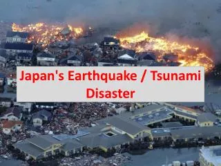
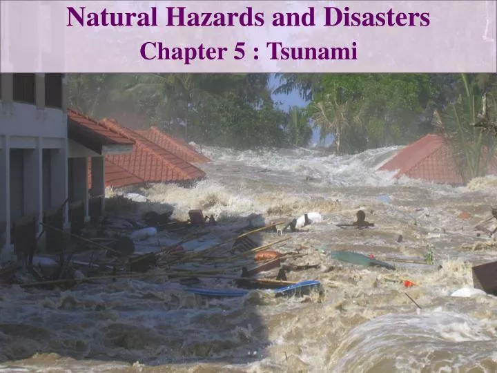
Natural Hazards and Disasters Chapter 5 : Tsunami. The Honshu Earthquake. http:// earthobservatory.nasa.gov /IOTD/ view.php?id =49648. Swept Away. Tourists in Phuket , Thailand felt an earthquake Less than two hours later, giant wave surged in from beach

E N D
Natural Hazards and Disasters Chapter 5 : Tsunami
The Honshu Earthquake http://earthobservatory.nasa.gov/IOTD/view.php?id=49648
Swept Away Tourists in Phuket, Thailand felt an earthquake Less than two hours later, giant wave surged in from beach More than 5,000 people died in that area
Tsunami Generation • Tsunami: Japanese name for harbor wave • Waves rise highest where focused in bays or harbors • Sometimes called tidal waves, but NOT related to tides • Most commonly generated by earthquakes • Also can be generated by any sudden displacement of large volume of water • Volcanic eruptions, landslides or rockfalls, volcano flank collapses, asteroid impacts
Earthquake-Generated Tsunami Most tsunami are generated during shallow-focus, underwater earthquakes which cause sudden rise or fall of seafloor, displacing large volume of water Most commonly, earthquake is on reverse or thrust fault in a subduction zone (occasionally on normal fault) Where subduction zone plates stick, overlying plate flexes upward in a coastal bulge In an earthquake, flexed edge snaps up and oceanward, displacing huge volume of water Tsunami waves move in both directions from location where they were generated
Earthquake-Generated Tsunami • Height of tsunami wave depends on • Earthquake magnitude • Area of rupture zone • Rate and volume of water displaced • Sense of ocean floor motion • Depth of water above rupture • Size of earthquake-generated tsunami in open ocean is limited to maximum displacement (offset) on fault • Vertical offset of 15 m from magnitude 8 earthquake • Maximum wave height (in open ocean) therefore 15 m
Earthquake-Generated Tsunami • Most vulnerable parts of U.S. and Canada are • Hawaii • Pacific coast: California, Oregon, Washington, British Columbia, Alaska • Somewhere around the Pacific Ocean: • On average, major tsunami forms once a decade • 30-meter-high wave hits once every 20 years • Subduction zones off Japan, Kamchatka, Aleutian Islands, Alaska, Mexico, Peru, Chile, Pacific northwest of U.S. are likely sources of tsunami-generating earthquakes
Earthquake-Generated Tsunami Tsunami from earthquake on Santa Catalina fault offshore of Los Angeles would reach Marina Del Rey (just north of L.A. airport) in eight minutes Earthquake-generated tsunami killed 51 people in Newfoundland in 1929 Series of large earthquakes that wrecked Lisbon, Portugal in 1755 were followed by 10-meter-high tsunami waves Major subduction-zone earthquake in the Caribbean could trigger tsunami that would inundate low-lying Gulf and East Coast states
Tsunami Generated by Volcanic Eruptions • Volcanic processes can displace large volumes of water and trigger tsunami • Fast-moving flows of hot volcanic ash • Submarine volcanic explosions • Collapse of volcano in giant landslide • Tsunami generated by volcanic eruptions are occasionally catastrophic, but poorly understood, maximum size unknown
Tsunami Generated by Volcanic Eruptions • Montserrat Island’s Soufriere Hills, 2003 • Volcano collapsed, spilled volcanic material into ocean, generated tsunami • Run-up as high as 21 m on nearby islands • Krakatau, 1883 • Mountain exploded in enormous eruption • 35 minutes later, series of waves as high as 35 m hit coastlines of Java and Sumatra • More than 35,000 people killed
Tsunami from Fast-Moving Landslides or Rockfalls • Can displace immense amounts of water and generate tsunami • Height of fall is more important than volume of mass that displaces water • Lituya Bay, Alaska, 1958 • Nearby earthquake detached section of cliff, fell into bay and created largest wave on record • Killed only two people • Southern Chile, 2007 • Magnitude 6.2 earthquake caused large landslide that triggered 7.6-meter-high waves
Tsunami from Fast-Moving Landslides or Rockfalls • Submarine landslides can also generate tsunami • 8,100 years ago: Storegga landslide offshore Norway caused 11-meter-high tsunami • West side of Lake Tahoe: • Shelf of lake sediments collapsed after melting of glaciers • Catastrophic landslide and tsunami • North half of sediment shelf did not collapse – may do so at some point in future
Tsunami from Fast-Moving Landslides or Rockfalls • Fractures along 40-km stretch of continental shelf off Virginia and North Carolina suggest possibility of future underwater landslide which could trigger tsunami • New Guinea, 1998 • Small subsea slide caused by earthquake generated tsunami that killed 2,200 people
Tsunami from Volcano Flank Collapse Flanks of many volcanic islands occasionally collapse and slide into ocean, displacing thousands of cubic kilometers of water Resultant tsunami waves can be hundreds of meters high, many times larger than any seen in historical times Hawaiian Island volcanoes are massive shield volcanoes with broad, gentle slopes above sea level and steep, rubbly, unstable slopes below sea level
Tsunami from Volcano Flank Collapse Massive shields spread outward under their own weight, form rifts along their crests Segments slide seaward, sometimes slowly, sometimes catastrophically Studies of ocean floor around Hawaii revealed 68 giant debris avalanches – some of which must have caused massive tsunami waves Similar situations on slopes of Mount Etna, Marquesas Islands, Reunion Island, Canary Islands Flank collapses occur probably about once every 100,000 years
Tsunami from Asteroid Impact • Impact of large asteroid into ocean would generate large tsunami that would radiate outward from impact site • Average frequency of impacts is low (1-kilometer asteroid impact occurs about once every million years) • 1-kilometer asteroid falling into 5-kilometer deep ocean: • Would generate 3-kilometer-deep cavity • Cavity walls would collapse at supersonic speeds • Would send plume high into atmosphere • Kilometer-high waves would crest, break, interfere with each other, cause immense run-up on shore • Waves might decrease in size fairly rapidly from impact site
Tsunami Movement • Waves described by wavelength, height, period • Tsunami in open ocean: • Small wave heights • Average wavelength about 360 kilometers • Period may be half an hour
Tsunami Movement • Typical waves: • Driven by wind • Particles travel in circular motion that fades downward • Velocity depends on wavelength • ‘Touch bottom’ at depths less than half wavelength • Tsunami waves: • Enormously long wavelength • ‘Touch bottom’ everywhere in ocean • Velocity depends on water depth • Slow down dramatically in shallower water
Tsunami Movement • Tsunami waves in open ocean: • Travel as fast as 870 kilometers per hour • May slow to 150-300 km/hr on continental shelf • Tsunami waves in shallower water: • Front of wave slows first but rear keeps coming • Wave becomes much shorter • Volume of wave remains same • Height must rise dramatically, up to six times height in open ocean
By the Numbers Velocity of Tsunami Waves Depends on water depth and gravity C = (gD)1/2 = 3.13(D)1/2 where C = velocity in meters per second D = depth in meters g = gravitational acceleration (9.8 m/s2) Example: D = 4600 meters C = 3.13(4600)1/2 = 3.13(67.8) = 763 km/hr Example: D = 100 meters C = 3.13(100)1/2 = 3.13(10) = 112.7 km/hr
Tsunami on Shore • Tsunami may appear like: • Ordinary breaking waves on shore, with greater velocity and much larger • Wall of water or high, breaking wave • Rapid rise of sea level, river than flows onshore • Waves advance much faster than person can run • Even strong swimmers are swept inland or carried out to sea • Loose debris is extremely dangerous
Coastal Effects Mouths of rivers and coastal bays funnel waves, dramatically raise height High tide can amplify waves Constructive interference can raise wave height Can refract all the way around island and constructively interfere on opposite side Low-lying Pacific and Caribbean islands are surrounded by coral reefs, steep drop-offs – tsunami waves forced to break on reef and have less impact on shore
Run-up Height that wave reaches onshore Depends on distance from fault rupture, whether wave strikes open coast or bay Evidence of past tsunami run-up can be seen as trimline, line along mountainside with tall trees upslope (unaffected) and shorter, younger trees downslope (wiped out by run-up)
Period Initial mound of water oscillates up and down few times before fading away Generates series of waves Arrival of tsunami wave generally followed by other waves, sometimes larger than first Waves could arrive onshore every 15 minutes Calm sea or retreating sea could be trough before next wave Reports often describe initial withdrawal of sea with hissing, roaring noise
Tsunami Hazard Mitigation • Land use zoning: limit buildings to elevations above those potentially flooded • Engineer structures to resist wave erosion and scour • Orient streets and building perpendicular to shore • Limits debris impact • Permits waves to penetrate without building higher • Reinforce shoreline with well-rooted trees that permit water to flow between them and slow wave • Large ditch or reinforced concrete wall can reduce impact of first wave
Tsunami Warnings Warning systems now perfected for far-field tsunami Tsunami warning network around Pacific Ocean monitors large earthquakes and ocean waves, transmits watches and warnings to 26 countries Travel time for tsunami can be accurately calculated Readings from tidal sensors, ocean bottom sensors detect ocean surface heights
Tsunami Warnings NOAA DART: Deep-ocean Assessment and Reporting of Tsunamis
Surviving a Tsunami Nearby earthquake may not allow time for official warning (15-30 minutes for first wave) Affected population should move inland or to higher ground If no high ground, move inland (tsunami waves dissipate on land) or to upper floor of well-reinforced building back from beach Never go to shore to watch tsunami Do not return after first wave
Future Giant Tsunami • Largest tsunami likely to impact people are from giant subduction-zone earthquakes or flank collapse of island shield volcano • Giant tsunami following huge subduction-zone earthquake in Pacific Northwest • Catastrophic collapse of flank of shield volcano on big island of Hawaii • Catastrophic collapse of flank of shield volcano on Canary Islands in Atlantic Ocean
Pacific Northwest Tsunami: Historical Record of Giant Tsunami • Last major earthquake in 1700 • Many giant earthquakes at intervals of few hundred years • Evidence of giant tsunami included: • Sedimentary layer sequence • Tsunami-flattened forests • Sand sheets up to 18 m above sea level
Pacific Northwest Tsunami: Historical Record of Giant Tsunami • Earthquake that breaks 1100-kilometer subduction zone would produce: • In Victoria, 4-meter-high waves 80 minutes later • In Seattle, 2-meter-high waves 6 hours later • Magnitude 7.6 earthquake on Seattle Fault: • In Seattle, 6-meter-high waves 20 minutes later • Drop of coastal area will raise sea level compared to land even more • Tsunami up to 16 m may invade some coastal bays
Kilauea, Hawaii: Potentially Catastrophic Volcano Flank Collapse Displaced coral blocks, scrubbed slopes are evidence of monstrous waves collapse of volcanic segment Head scarps of collapsed segment became gigantic coastal cliffs (pali), some more than 200 m high Landslides occur during major eruptive cycles, about every 100,000 years Most recent slide was 105,000 years ago 1975: southern flank of Kilauea moved 7 m seaward, dropped 3 m in magnitude 7.2 earthquake
Canary Islands: Potential Catastrophe in Coastal Cities Across the Atlantic • Evidence of repeated collapse of volcano flanks • May have been initiated by subsidence of summit caldera into magma chamber • Most recent was 170,000 years ago • Next collapse could come at any time • Wave could reach Portugal in 2 hours • Wave could reach Great Britain in 3 hours • Wave could reach Canada and U.S. in 6 hours, with heights up to 20-25 m
Case In Point Immense Local Tsunami from a Landslide: Lituya Bay, Alaska, 1958 Site of one of highest wave run-ups ever recorded Nearby magnitude 7.5 earthquake caused mass of rock and ice to fall into bay, created wave 150 m high Wave surged to 524 m high over ridge at 150-210 km/hr Three fishing boats on bay – two survived Examination of shoreline trees showed two much higher trimlines Glacier Bay could be next site of similar event – cruise ships now avoid mouth of bay
Case In Point Subduction-Zone Earthquake Generates a Major Tsunami: Anchorage, Alaska, 1964 Magnitude 8.6 earthquake on Alaska subduction zone Strip of seafloor raised 10 meters above sea level, displaced water to generate tsunami Giant waves hit Kenai Peninsula in 19 minutes, Kodiak Island in 34 minutes, Valdez Inlet (drowning 122 people) Warnings issued for California Five waves hit and severely damaged Crescent City, killing 15 people
Case In Point Lack of Warning and Education Costs Lives: Sumatra Tsunami, 2004 Magnitude 9.15 earthquake broke 1,200 km of fault length, shook violently for up to 8 minutes Nearby Sumatra: impossible to stand or walk during earthquake, destroyed buildings First wave arrived 15 minutes later, swept up to 8 km inland, with 24-meter-high run-up on one hill Most people live in low-lying coastal areas Little or no warning of incoming waves
Case In Point Less than two hours before waves hit coast of Thailand, east coast of Sri Lanka, east coast of India Seven hours later, waves hit Somalia No warning network in Indian Ocean Numerous attempts at issuing warnings but few were successful Chief Indonesian meteorologist had warned of tsunami possibility in summer 1998: labeled crazy and dangerous, but now considered hero
Case In Point • Lack of Warning and Education Costs Lives: Sumatra Tsunami, 2004 • Even with warning system, most of Sumatra was too close to have had time for escape • Delay in calculating true magnitude of earthquake cost some time, but warnings still could have saved lives in Thailand, Sri Lanka, India • Public education could have saved lives • Ten-year-old girl had recently learned about tsunami in school, saved hundreds on beach • Dock worker had seen television special on tsunami, warned nearby community after earthquake, saved hundreds of lives