Download
1 / 2
30 likes | 165 Views
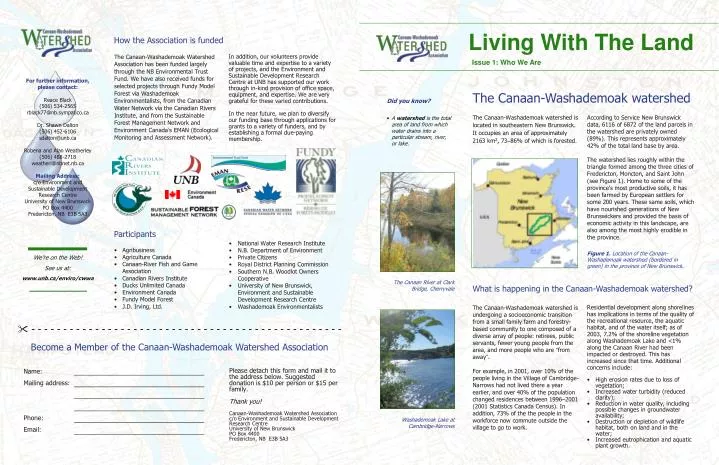
Washademoak Lake at Cambridge-Narrows. The Canaan River at Clark Bridge, Cherryvale. We’re on the Web! See us at: www.unb.ca/enviro/cwwa. Living With The Land. How the Association is funded.

E N D
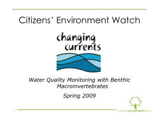
Washademoak Lake at Cambridge-Narrows The Canaan River at Clark Bridge, Cherryvale We’re on the Web! See us at: www.unb.ca/enviro/cwwa Living With The Land How the Association is funded The Canaan-Washademoak Watershed Association has been funded largely through the NB Environmental Trust Fund.We have also received funds for selected projects through Fundy Model Forest via Washademoak Environmentalists, from the Canadian Water Network via the Canadian Rivers Institute, and from the Sustainable Forest Management Network and Environment Canada’s EMAN (Ecological Monitoring and Assessment Network). In addition, our volunteers provide valuable time and expertise to a variety of projects, and the Environment and Sustainable Development Research Centre at UNB has supported our work through in-kind provision of office space, equipment, and expertise.We are very grateful for these varied contributions. In the near future, we plan to diversify our funding base through applications for grants to a variety of funders, and by establishing a formal due-paying membership. Issue 1: Who We Are For further information, please contact: Reace Black (506) 534-2565 rblack77@nb.sympatico.ca Dr. Shawn Dalton (506) 452-6106 sdalton@unb.ca Robena and Alan Weatherley (506) 488-2718 weatherl@nbnet.nb.ca Mailing Address: c/o Environment and Sustainable Development Research Centre University of New Brunswick PO Box 4400 Fredericton, NB E3B 5A3 The Canaan-Washademoak watershed • Did you know? • A watershed is the total area of land from which water drains into a particular stream, river, or lake. The Canaan-Washademoak watershed is located in southeastern New Brunswick.It occupies an area of approximately 2163 km2, 73–86% of which is forested. According to Service New Brunswick data, 6116 of 6872 of the land parcels in the watershed are privately owned (89%).This represents approximately 42% of the total land base by area. The watershed lies roughly within the triangle formed among the three cities of Fredericton, Moncton, and Saint John (see Figure 1). Home to some of the province’s most productive soils, it has been farmed by European settlers for some 200 years. These same soils, which have nourished generations of New Brunswickers and provided the basis of economic activity in this landscape, are also among the most highly erodible in the province. Participants • National Water Research Institute • N.B. Department of Environment • Private Citizens • Royal District Planning Commission • Southern N.B. Woodlot Owners Cooperative • University of New Brunswick, Environment and Sustainable Development Research Centre • Washademoak Environmentalists • Agribusiness • Agriculture Canada • Canaan-River Fish and Game Association • Canadian Rivers Institute • Ducks Unlimited Canada • Environment Canada • Fundy Model Forest • J.D. Irving, Ltd. Figure 1. Location of the Canaan-Washademoak watershed (bordered in green) in the province of New Brunswick. What is happening in the Canaan-Washademoak watershed? The Canaan-Washademoak watershed is undergoing a socioeconomic transition from a small family farm and forestry-based community to one composed of a diverse array of people: retirees, public servants, fewer young people from the area, and more people who are “from away”. For example, in 2001, over 10% of the people living in the Village of Cambridge-Narrows had not lived there a year earlier, and over 40% of the population changed residences between 1996–2001 (2001 Statistics Canada Census). In addition, 73% of the the people in the workforce now commute outside the village to go to work. Residential development along shorelines has implications in terms of the quality of the recreational resource, the aquatic habitat, and of the water itself; as of 2003, 7.2% of the shoreline vegetation along Washademoak Lake and <1% along the Canaan River had been impacted or destroyed. This has increased since that time. Additional concerns include: " - - - - - - - - - - - - - - - - - - - - - - - - - - - - - - - - - - - - - - - - - - - - - - - - - Become a Member of the Canaan-Washademoak Watershed Association Name: Mailing address: Phone: Email: Please detach this form and mail it to the address below. Suggested donation is $10 per person or $15 per family. Thank you! Canaan-Washademoak Watershed Association c/o Environment and Sustainable Development Research Centre University of New Brunswick PO Box 4400 Fredericton, NB E3B 5A3 • High erosion rates due to loss of vegetation; • Increased water turbidity (reduced clarity); • Reduction in water quality, including possible changes in groundwater availability; • Destruction or depletion of wildlife habitat, both on land and in the water; • Increased eutrophication and aquatic plant growth.
Arthur Black Cambridge-Narrows resident “I think the main reason that people have left the farms in this area would be on account of there just wasn’t enough income.” Robena Weatherley Cambridge-Narrows resident “One of the major changes in how we relate to the waterway is that now it’s more valued for recreation, and that’s very different from how we felt about it before when it was really an integral part of our livelihood.” Alta Tait Cherryvale resident “We’ve always enjoyed the landscape—the freedom to go skiing, or fishing, or hunting. Reace Black Cherryvale resident “I’m just amazed at the vastness of this watershed and all the things it has to offer.” Issue 1: Who We Are Living With The Land Living With The Land Issue 1: Who We Are About the Canaan-Washademoak Watershed Association What are some of the Association’s findings? The Canaan-Washademoak Watershed Association is a community-based organization formed in 2002 in response to local concerns about perceived changes in water quality, recreational fishing opportunities, and social structure of communities in the area. Our goals are to protect and enhance the ecological structure and function of the Canaan River, Washademoak Lake, and their tributaries and, in so doing, to (re)connect people in the region with these valuable aquatic resources. Members work toward these goals through a collaborative, community-based, ecosystem approach to watershed planning and management. The activities of the Canaan-Washademoak Watershed Association focus on the following challenges: • Socioeconomic: • The new highway between Fredericton and Moncton renders some portion of the watershed commutable from each of these cities; • Increasing numbers of year-round and summer residents are resulting in changes to some of the characteristics of the local communities; • The roles of agriculture and forestry in the Canaan-Washademoak watershed are changing; • We are finding a disconnect between the perceptions and reality of watershed dynamics: • less than 9% of the working population is involved in forestry or farming (there are spatial patterns to this); • 39% of the workforce in Cambridge-Narrows is working in education, social services, or health care (i.e. probably commuting to the cities or other nearby communities to work). • To manage (and plan and design for management) in a way that protects the ecological structure and function of landscapes in the context of human activity. • Biophysical: • Increased silt deposition is leading to infilling of coves; • Increased algal growth and sediment coatings is apparent on rocks; • As of 2003, 7.2% of the riparian zone vegetation along Washademoak Lake has been removed; <1% along Canaan River. This has increased since that time. • Indicators of a healthy ecosystem (salmonids, certain insect species) are present in the system. In so doing, the Association hopes to realize and encourage strong communities and healthy ecosystems in the Canaan-Washademoak watershed. Relationships between biophysical and socioeconomic conditions: • The riparian zone of the main stem is mostly in private ownership, as is all of the region around the lake; • There are changes in land use with greatly increased residential development pressure on the shorelines; • There are also changes in social norms: the urban aesthetic is being imported to the countryside. • To understand the reciprocal relationships between human communities and activities, and the ecosystems that support them, and; We are drawn to the region for its recreational and aesthetic qualities; these depend upon a healthy ecosystem. How can you help? Activities of the Watershed Association By volunteering your time, skills, or suggestions to the Canaan-Washademoak Watershed Association you can help strengthen its public voice and add momentum to its initiatives; an organisation’s success requires broad community participation. The Canaan-Washademoak Watershed Association holds regular meetings, hosts speaker series, and community field days. Our calendar of events can be found on our website: www.unb.ca/enviro/cwwa To participate, offer suggestions, or sign up for specific committees, please contact any of the individuals listed overleaf. The Association’s activities include: • Volunteer outreach, education, and recruitment; • Community-based ecological monitoring (forest biodiversity, benthic macroinvertebrate sampling, water quality and fish population studies); • Atlas of social and ecological characteristics of the watershed; • Examination of trends in agriculture: “Agriculture in the Canaan-Washademoak Watershed”, www.unb.ca/enviro/cwwa/products.html; • Integrated planning pilot project: watershed management plan; • Forest and Stream Ecology program with local schools. Figure 2. Sampling benthic invertebrates on the Canaan River. Figure 3. Washademoak Lake.