Download
1 / 35
360 likes | 612 Views
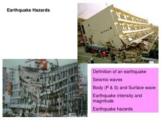
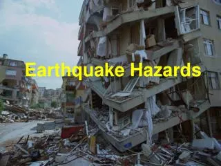
Lecture 17 Earthquake Hazards. Big earthquakes Earthquake damages: aftershocks, amplification, liquefaction, landslides, fire Earthquake hazard mitigation Tsunami. Big earthquakes. appr. annual frequency of earthquakes description mag on the order of

E N D
Lecture 17 Earthquake Hazards • Big earthquakes • Earthquake damages: aftershocks, amplification, liquefaction, landslides, fire • Earthquake hazard mitigation • Tsunami
Big earthquakes appr. annual frequency of earthquakes • description mag on the order of • great >8 1 • major >7 10 • strong >6 100 • moderate >5 1000
earthquake magnitude and energy equivalence • mag energy release appr. equivalence • 2 600x1012 ergs 1000 pound of explosives, • rumbling of trains, smallest human can feel • 6 600x1018 ergs 1946 Bikini atomic bomb test • 10 600x1024 ergs annual US energy consumption • 1811-1812 New Madrid, Missouri, three major earthquakes, M~8, largest in contiguous US • 1964 Alaska earthquake, M~9, 131 death, one of the largest ever recorded.
examples of most destructive earthquakes • 1556 Shanxi Huaxian, China earthquake, 830 thousands deaths, possibly the greatest natural disaster ever. • 1976 Tangshang, China M7.8, 240 thousand deaths. • 1994 North ridge, CA, M6.7, 61 deaths, damage exceeding $15 billion. • 1995 Kobe, Japan, M6.9, 5472 death, damage exceeding $100 billion.
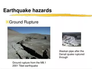
Areas away from plate boundaries are not necessarily immune from earthquakes. This is damage to Charleston, S. Carolina caused by the Aug 31, 1886 earthquake there. This was the greatest earthquake in the eastern US. Strong vibrations were felt even in Chicago.
Destruction from seismic vibrations The amount of structural damage due to vibrations depends on: • strength of earthquake • duration (and after shocks) • distance from epicenter • the site materials • building design, building natural periods
Earthquake intensity • Modified Mercalli intensity scale (P.408) measures the damage from an earthquake at a specific location. • The intensity ranges from I (not felt) to XII (total destruction). • Appr. relationship between MM and magnitude and ground acceleration (P.409)
Damage caused to a five-story JC Penney building, Anchorage, Alaska by 1964 Alaskan earthquake. Very little structural damage was incurred by the adjacent building. (NOAA)
Resonance with building natural periods • At close distances, the most powerful vibrations are in 0.5-5 Hz, produced by S and short-period surface waves (Lg). • Typical building of 10 storeys has T=1s; each storey adds 0.1s.
aftershocks: After a main earthquake, there are aftershocks in the following minutes, hours, days, months, or years -- The number of aftershocks decreases with time. The chance of one or more aftershocks with equal or larger magnitude within 7 days can be over 50% in California. • Aftershocks may cause previously damaged, yet still standing, structures to collapse. Thus, for engineers, damaged public buildings should be examined immediately and closed down if necessary to minimize the risks of aftershocks. • Example: 1952 Ken county, CA earthquake (M7.7) had a M5.8 aftershock, which caused more damage to Bakersfield than the main one.
amplification by soft sediments • Massive bedrock provides best foundation because it passes wave motions on, resulting less vibration to building structure. • Soft sediments generally amplify the vibrations more than solid bedrock.
Seismograms from an aftershock of 1989 Loma Prieta earthquake show that shaking is greatly amplified in soft mud as compared to firmer materials. The portion of the Cypress Freeway structure in Oakland, CA that stood on soft mud (dashed red line) collapsed during the main shock.
liquefaction • Saturated fine sands and silts are subject to liquefaction during earthquake vibrations, in which water rises and a stable soil turns into a mobile fluid that has weak shear strength. • Underground objects such as sewer lines may literally float toward the surface and buildings settle and collapse.
Effects of liquefaction. The tilted building rests on unconsolidated sediment that behaved like quicksand during the 1985 Mexican earthquake. (J.L. Beck)
“Mud volcanoes” produced by 1989 Loma Prieta earthquake. They formed when geysers of sand and water shot from the ground, an indication of liquefaction. (R.Hilton)
Landslides • A photo of Turnagain Heights landslides caused by the 1964 Alaskan earthquake.
Landslides of Turnagain Heights, Alaska caused by the 1964 Alaskan earthquake. In less than 5 min, as much as 200 m of the bluff area was destroyed. (USGS)
Fire caused by earthquakes • San Francisco in flames after the 1906 earthquake. The greatest destruction was caused by the fires, which started when gas and electrical lines were severed.
Fire hazards after earthquakes • Ignited by broken gas and electrical lines, toppled stoves • Added fuel from chemicals, rubbers, gas stations • Fire services not alerted because of lack of information • Roads blocked by earthquake damages • Water in emergency tanks underground run out
Shaking hazard map based on past earthquake activities and how far shaking extends from quake sources. Colors show the levels of horizontal shaking that have a 10% chance of being exceeded in a 50-year period. (USGS)
Aerial view of the collapsed freeway interchange between I-5 and the Antelope Valley Freeway (State 14) after Northridge Earthquake, Jan. 17, 1994 (Mw 6.7). (photo: Kerry Sieh)
Tsunami • Tsunami means "great wave in harbor" in Japanese. The name is fitting as these giant waves have frequently brought death and destruction to harbors and coastal villages. • In physics, tsunami is just like ordinary wind driven ocean waves. They are gravity waves: Gravity is the primary restoring force of the motions. But tsunamis are distinguished by particularly long periods (200-2000s) and wavelengths of tens of kilometers.
A tsunami hit Hilo, Hawaii on April 1, 1946, 4h 55m after it originated from a large earthquake in Aleutian trench. Tsunami runup reached 16m. Total 159 killed in the five main islands, including 96 deaths in Hilo. No warning was issued. (UC Berkeley)
Tsunami (continued) • These long period ocean waves can travel thousands of kilometers across the ocean with the speed (500-9500 km/hr) equivalent to that of jetliners. The wave speed decreases with the decrease of ocean depth. • The height of a tsunami in the open ocean is usually less than 1 meter (so it can pass undetected), but the waves can sometimes exceed 30 m as they slow down in shallow water and pile up.
Illustration of a tsunami generated by displacement of ocean floor. The wave speed decreases with the decrease of ocean depth. The height of a tsunami in the open ocean is usually less than 1 meter (so it can pass undetected), but the waves can sometimes exceed 30 m as they slow down in shallow water and pile up. (Tarbuck and Lutgents)
Tsunami are excited by large-scale submarine displacements of water due to submarine landslides, submarine volcanic eruptions, sea bottom faulting (earthquakes), etc.
Tsunami at Hawaii • Being in the middle of the Pacific Ocean, surrounded by a ``ring of earthquakes'', Hawaii is exposed to real damages and threats of tsunamis. On 1946, April Fools Day, a large earthquake occurred in Aleutian trench, 4h 55m later, large tsunami hit Hawaii. Tsunami sunup reached 16m. Hilo was the most affected. Total 159 killed in the five main islands, including 96 deaths in Hilo. No warning was issued. • Two years later, the now Tsunami Warning System in Hawaii was set up. The system took full advantage of the fundamental relationship between tsunamis and earthquakes: (1) large earthquakes can generate tsunamis; (2) seismic waves travel at 30 to 60 times the speed of a tsunami (i.e. minutes vs hours).
Tsunami travel times to Honolulu, Hawaii from various locations of Pacific rim. (Tarbuck and Lutgens)
Examples of tsunami warning • 1957, March, 9. A magnitude 8 quake occurred in the Aleutian Trench. A Tsunami Watch was issued. 4h55m later, 10 ft waves hit Hilo. However Kauai had larger damages. The runup reached 32 ft. No loss of life. • 1960, May 22. A magnitude 8.5 quake shook Chile. A large tsunami was immediately excited. It traveled 6600 miles in 15h and hit the Hawaii islands. Hilo again had the most extensive damage with 61 deaths. The tsunami warning was very accurate but the public response was a failure.