Download
1 / 5
50 likes | 57 Views
Guest presenter at the 2017 Geospatial Summit providing a "reality check" on NGS plans, highlighting benefits, challenges, and transition tools for the new datums. Close collaboration, interagency communication, and support of the geodesy discipline are essential.

E N D
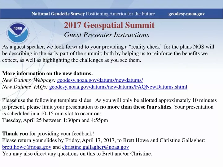
2017 Geospatial Summit Guest Presenter Instructions As a guest speaker, we look forward to your providing a “reality check” for the plans NGS will be describing in the early part of the summit; both by helping us to reinforce the benefits we expect, as well as highlighting the challenges as you see them. More information on the new datums: New Datums Webpage: geodesy.noaa.gov/datums/newdatums/ New Datums FAQs: geodesy.noaa.gov/datums/newdatums/FAQNewDatums.shtml Please use the following template slides. As you will only be allotted approximately 10 minutes to present, please limit your presentation to no more than these four slides. Your presentation is scheduled in a 10-15 min slot to occur on: Tuesday, April 25 between 1:30pm and 4:55pm Thank you for providing your feedback! Please return your slides by Friday, April 17, 2017, to Brett Howe and Christine Gallagher: brett.howe@noaa.gov and christine.gallagher@noaa.gov You may also direct any questions on this to Brett and/or Christine.
Feedback on the New Datums National Geospatial-Intelligence Agency (NGA) Stephen Malys NGA Senior Scientist for Geodesy and Geophysics 2017 Geospatial Summit April 24 to 25, 2017
Preparation • Our major products/services which will be affected by the new datums: • Homeland Security Infrastructure Program • Homeland Infrastructure Foundation-Level Data (HIFLD) • Collaboration among NGA, DHS, USGS • Geodetic Surveys on CONUS Weapons Test Ranges will continue to use WGS 84 (Gxxxx) and EGM 2008 • Holloman AFB • White Sands Test Range • Eglin AFB • Patrick AFB • Vandenberg AFB • Our preparations to date include: • N/A
Advantages / Challenges • We are excited because...Expected advantages of the new datums for your organization, its products, or services • The replacement to NAD 83 will be closely aligned with the ITRF and therefore closely aligned with the current (and future, 2022) realizations of WGS 84 • The replacement to NAVD 88 will be more closely aligned with our best global geoid: EGM 2008 • These NGS efforts represent significant milestones toward a common, Global Geodetic Reference Frame for all geospatial data • A major goal of Geodesy for many decades • Will reduce confusion for most practical surveying applications • We are concerned because...Expected challenges of the new datums for your organization, its products, or services • There will likely be small differences between NAD xx and WGS 84 (Gxxxx) • A topic of scientific interest (1 -10mm level) • Will the community accept these small differences as statistically insignificant? • Of no practical interest?
Transition Tools / Outreach Needs • The tools, products, or services we need most (from NGS or others) are: • GPS and other GNSS data sets from ‘Foundation CORS’ • Facilitate direct comparison with WGS 84 reference frame • The outreach we need most (from NGS or others): • Continued close collaboration between NGA, NOAA and NASA • Support and maintain the health of the Geodesy discipline within the US Government • Interagency Collaboration and communication to surveying community on US Gov policy regarding use of foreign GNSS • Multi-GNSS surveying receivers will likely become commonplace