Download
1 / 56
560 likes | 569 Views
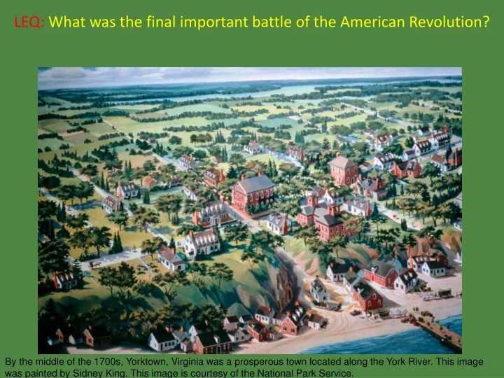
LEQ: What was the final important battle of the American Revolution?. By the middle of the 1700s, Yorktown, Virginia was a prosperous town located along the York River. This image was painted by Sidney King. This image is courtesy of the National Park Service.

E N D
LEQ:What was the final important battle of the American Revolution? By the middle of the 1700s, Yorktown, Virginia was a prosperous town located along the York River. This image was painted by Sidney King. This image is courtesy of the National Park Service.
LEQ:What was the final important battle of the American Revolution? Yorktown, Virginia By the middle of the 1700s, Yorktown, Virginia was a prosperous town located along the York River. This image was painted by Sidney King. This image is courtesy of the National Park Service.
Yorktown Basics American General Benjamin Lincoln appears mounted on a white horse. He extends his right hand toward the sword carried by Charles O’Hara, who heads the long line of troops that extends into the background. To the left, French officers appear standing and mounted beneath the white banner of the royal Bourbon family. On the right are American officers beneath the Stars and Stripes. General George Washington, riding a brown horse, stayed in the background because Lord Cornwallis himself was not present for the surrender. This image was painted by John Trumbull (1756-1843) in 1820. It is courtesy of the Architect of the Capitol.
YorktownVocabulary This image is from wordinfo.info.
The act of surrounding and attacking a fortified place in order to isolate it from help and supplies. The purpose is to lessen the resistance of the defenders and make their capture possible. This image shows the position of the armies during the siege of Yorktown. The British are shown in red. The Americans are shown in light blue. The French are outlined in purple. This image is courtesy of britishbattles.com.
SiegeThe act of surrounding and attacking a fortified place in order to isolate it from help and supplies. The purpose is to lessen the resistance of the defenders and make their capture possible. This image shows the position of the armies during the siege of Yorktown. The British are shown in red. The Americans are shown in light blue. The French are outlined in purple. This image is courtesy of britishbattles.com.
During the siege of Yorktown, the Americans and the French dug trenches that brought them closer and closer to the British lines. The French were experts at siege warfare. They directed the Americans in digging trenches that would protect them, and slowly come closer to the British lines. This painting was created by Sidney King. This image is courtesy of the National Park Service.
Land surrounded by water on three sides. Florida is a peninsula. This image is courtesy of nasa.gov.
PeninsulaLand surrounded by water on three sides. Florida is a peninsula. This image is courtesy of nasa.gov.
Yorktown is located on the Virginia Peninsula. Yorktown is now known as York. The Virginia Peninsula borders the York River, the James River, and the Chesapeake Bay. This image is courtesy of Wikimedia Commons.
An agreement acceptable to both sides. Signing the Preliminary Treaty of Peace at Paris, November 30, 1782. John Jay and Benjamin Franklin are standing at the left. This print is from a painting by Carl Wilhelm Anton Seiler (1846-1921). The print was created in 1905. This image is courtesy of Wikimedia Commons.
CompromiseAn agreement acceptable to both sides. Signing the Preliminary Treaty of Peace at Paris, November 30, 1782. John Jay and Benjamin Franklin are standing at the left. This print is from a painting by Carl Wilhelm Anton Seiler (1846-1921). The print was created in 1905. This image is courtesy of Wikimedia Commons.
It took two years for the Americans and British to reach a compromise that led to the signing of the Treaty of Paris. This image shows the signing of the Treaty of Paris on September 3, 1783. American delegates included from left to right: John Jay, John Adams, Benjamin Franklin, and Henry Laurens. David Hartley and Richard Oswald represented Great Britain. This image is courtesy of treatyofpariscenter.org.
An agreement by Great Britain and the United States that officially ended the American Revolution. This is the signature page from the Treaty of Paris. This image is courtesy of the National Archives and Wikimedia Commons.
Treaty of Paris (1783)An agreement by Great Britain and the United States that officially ended the American Revolution. This is the signature page from the Treaty of Paris. This image is courtesy of the National Archives and Wikimedia Commons.
In the Treaty of Paris, signed on September 3, 1783, Great Britain officially acknowledged the independence of the American colonies. American Commissioners of the Preliminary Peace Agreement with Great Britain also sometimes referred to as "Treaty of Paris" From left to right: John Jay, John Adams, Benjamin Franklin, Henry Laurens, and William Temple Franklin. The British commissioners refused to pose, and the picture was never finished. This painting was created from 1783-1784 by Benjamin West and is courtesy of Wikimedia Commons.
YorktownPeople to Meet This painting shows French General Jean de Rochambeau and United States General George Washington giving their last orders before the final attack on the British lines. This image, created by Auguste Couder (1790-1873) in 1836 is titled Bataille de Yorktown. This image is courtesy of the Palace of Versailles and of Wikimedia Commons.
Commander-in-Chief of the American forces at the Siege of Yorktown. George Washington (1732-1799) was born in Virginia. After the American Revolution he hoped to settle on his plantation at Mount Vernon, Virginia. This painting was created by Rembrandt Peale (1778-1860) circa 1850. This image is courtesy of Wikimedia Commons.
George WashingtonCommander-in-Chief of the American forces at the Siege of Yorktown. George Washington (1732-1799) was born in Virginia. After the American Revolution he hoped to settle on his plantation at Mount Vernon, Virginia. This painting was created by Rembrandt Peale (1778-1860) circa 1850. This image is courtesy of Wikimedia Commons.
Commander-in-Chief of the French army at the Siege of Yorktown. Jean-Baptiste Donatien de Vimeur, comte de Rochambeau (1725-1807) was born in France and was schooled at a Jesuit college. During the Seven Years War, he fought in Europe. This painting was created by Charles Philippe Lariviere (1798-1876) in 1834. This image is courtesy of the Palace of Versailles and of Wikimedia Commons.
Jean de RochambeauCommander-in-Chief of the French army at the Siege of Yorktown. Jean-Baptiste Donatien de Vimeur, comte de Rochambeau (1725-1807) was born in France and was schooled at a Jesuit college. During the Seven Years War, he fought in Europe. This painting was created by Charles Philippe Lariviere (1798-1876) in 1834. This image is courtesy of the Palace of Versailles and of Wikimedia Commons.
Admiral who was in charge of the French Navy during the siege of Yorktown. Francois-Joseph Paul, marquis de Grasse Tilly, comte de Grasse (1722-1788) was born in France and entered the French navy at the age of 19. This image is courtesy of Wikimedia Commons.
Francois de GrasseAdmiral who was in charge of the French Navy during the siege of Yorktown. Francois-Joseph Paul, marquis de Grasse Tilly, comte de Grasse (1722-1788) was born in France and entered the French navy at the age of 19. This image is courtesy of Wikimedia Commons.
General who commanded the British army at the Siege of Yorktown. Charles Cornwallis (1738-1805) was born in an aristocratic British family and saw service in the Seven Years War in Europe. This painting of Charles Cornwallis was created by John Singleton Copley (1738-1815) circa 1795. This image is courtesy of Wikimedia Commons.
Charles CornwallisGeneral who commanded the British army at the Siege of Yorktown. Charles Cornwallis (1738-1805) was born in an aristocratic British family and saw service in the Seven Years War in Europe. This painting of Charles Cornwallis was created by John Singleton Copley (1738-1815) circa 1795. This image is courtesy of Wikimedia Commons.
YorktownMaps This image shows original 13 colonies that eventually became the first 13 states of the United States. With the exception of Virginia, this map approximates their present boundaries. The image is courtesy of humanities7.wordpress.com.
YorktownFind Yorktown on this map of the current United States. This map shows the present boundaries of the states. The image is courtesy of the University of Texas.
YorktownFind Yorktown on this map of the current United States. Yorktown is now marked by a red dot and the word “Yorktown.” The image is courtesy of the University of Texas.
Chesapeake Bay This image shows the 50 States of the United States. This image is courtesy of the University of Texas.
Chesapeake Bay The Chesapeake Bay is now colored blue. This image shows the 50 States of the United States. This image is courtesy of the University of Texas.
New York CityFind New York City on this map of the current United States. This map shows the present boundaries of the states. The image is courtesy of the University of Texas.
New York CityFind New York City on this map of the current United States. New York City is now marked by a red dot and the words “New York.” The image is courtesy of the University of Texas.
Rhode IslandFind Rhode Island on this map of the current United States. This map shows the present boundaries of the states. The image is courtesy of the University of Texas.
Rhode IslandFind Rhode Island on this map of the current United States. Rhode Island is now colored red. The image is courtesy of the University of Texas.
Virginia Find Virginia on this map of the current United States. This map shows the present boundaries of the states. The image is courtesy of the University of Texas.
Virginia Find Virginia on this map of the current United States. Virginia is now colored red. The image is courtesy of the University of Texas.
North Carolina Find North Carolina on this map of the current United States. This map shows the present boundaries of the states. The image is courtesy of the University of Texas.
North CarolinaFind North Carolina on this map of the current United States. North Carolina is now colored red. The image is courtesy of the University of Texas.
South CarolinaFind South Carolina on this map of the current United States. This map shows the present boundaries of the states. The image is courtesy of the University of Texas.
South CarolinaFind South Carolina on this map of the current United States. South Carolina is now colored red. The image is courtesy of the University of Texas.
GeorgiaFind Georgia on this map of the current United States. This map shows the present boundaries of the states. The image is courtesy of the University of Texas.
GeorgiaFind Georgia on this map of the current United States. Georgia is now colored red. The image is courtesy of the University of Texas.
Appalachian MountainsFind the Appalachian Mountains on this map of the United States. This map shows the present boundaries of the states. The image is courtesy of imageck.com.
Appalachian MountainsFind the Appalachian Mountains on this map of the United States. This map shows the fine artwork of Mr. Housch in placing brown lines in the approximate area where the Appalachian Mountains are located. The image is courtesy of imageck.com.
Land controlled by the 13 Original ColoniesFind the Land Controlled 13 original Colonies on this map of the current United States. This map shows the present boundaries of the states. The image is courtesy of imageck.com.
Land controlled by the 13 Original ColoniesFind the 13 original colonies on this map of the current United States. The 13 original states are now highlighted in red. The image is courtesy of imageck.com.
Mississippi RiverFind the Mississippi River on this map of the United States. This map shows the present boundaries of the states. The image is courtesy of imageck.com.
Mississippi RiverFind the Mississippi River on this map of the United States. The Mississippi River is now highlighted in blue. The image is courtesy of imageck.com.
Land Belonging to the United States After the American RevolutionFind the Land Belonging to the United States after the Revolution on this map. This map shows the present boundaries of the states. The image is courtesy of imageck.com.
Land Belonging to the United States After the American RevolutionFind the Land Belonging to the United States after the Revolution on this map. The land belonging to the United States after the American Revolution is now highlighted in red. The image is courtesy of imageck.com.