Download
1 / 58
580 likes | 712 Views
Dynamic Earth Plate Tectonics. Earth’s Interior. A Slice of the Earth. The Crust. Thin, solid, outermost layer of the Earth Between 5-100 km thick Composed primarily of silicates (Si, O -------------------------------------------------------- Can you answer? What rock type?

E N D
Dynamic Earth Plate Tectonics
The Crust • Thin, solid, outermost layer of the Earth • Between 5-100 km thick • Composed primarily of silicates (Si, O -------------------------------------------------------- • Can you answer? • What rock type? • How do other rock types form here? • What processes change the crust?
Lithosphere and Mantle • Mantle: The layer below the crustcomposedwith more iron and magnesium than the crust, making it more dense. • Lithosphere -uppermost part of the mantle is solid and, along with the crust, forms the lithosphere. Earthquakes occur in this layer. • It’s the lithosphere that breaks into the thick, moving slabs of rock that geologist’s call tectonic plates
Asthenosphere - Mantle • Asthenosphere - partially molten layer beneath the lithosphere. As rock heats up, it becomes pliable or ‘plastic’.Rock here is hot enough to fold, stretch, compress, and flow very slowly without fracturing. Think about Silly Putty.
Earth’s Core • Super-dense, about 5 times as dense as the rock we walk on at the surface! • Made up of metallic iron-nickel alloy. • Diameter of 6,972 kilometers is larger than the planet Mars! • The core of the Earth is made up of two distinct layers: • liquid outer layer • solid inner core
An Earthly Review • Fours layers ThicknessComposition • Crust (solid) 5 - 35 km Si, O • Mantle (plastic like) 2,870 km Si, O, Mg, Fe • Lithosphere • Asthenosphere • Core • Outer Core (liquid) 2,300 km Fe, Ni • Inner Core (solid) 1,170 km Fe, Ni • Total Thickness 6,370 km (approximate)
Now climb back up to the lithosphere to take a closer look at tectonic plates.
Magma is heated and rises • Magma spreads out, plates move apart. Density changes in the magma due to heating causes magma to rise toward the lithosphere. As it reaches the lithosphere it spreads horizontally moving the crustal plates with it.
Magma cools and sinks • Magma sinks, plates dragged towards each other. • As magma cools, its density increases and it begins to sink • This is the process of subduction.
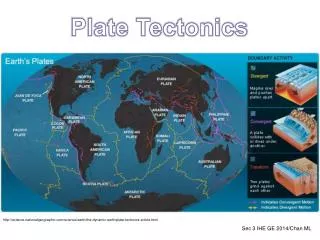
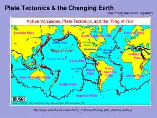
Plate Boundaries • Divergent<---A---- ----B---> • Plates move apart, magma rises and creates a ridge • Convergent----A---> <---B---- • Plates collide, one subducts, one rises. Usually accompanied by faulting • Transform----A---> <---B---- - Plates slip past one another
Divergent Boundary • Almost all the Earth's new crust forms at divergent boundaries, • Most are not well known because they lie deep beneath the oceans. • These are zones where two plates move away from each other, allowing magma from the mantle to rise up and solidify as new crust • The mid-Atlantic ridge is a good example
Divergent Boundary in Africa • The Arabian peninsula and Africa were once linked to form a single continent, they are now being ripped apart
Sea Floor Spreading The mid-Atlantic ridge is spreading at a rate of 4 cm per year.
Continental vs. Oceanic plate convergence • The dense, leading edge of the oceanic plate actually pulls the rest of the plate into the flowing asthenosphere and a subduction zone is born! • A deep trench forms where the two plates intersect • Volcanic arc forms above the subduction zone.
Oceanic vs. Oceanic plate convergence • When two oceanic plates collide, the plate that is older, therefore colder and denser, is the one that will sink. • A subduction zone forms and a curved volcanic mountain chain forms called island arcs form. • The Aleutian Peninsula of Alaska is an excellent example of a very volcanically-active island arc.
Continental vs. continental plate convergence • The Himalayan mountain range provides a spectacular example of continent vs. continent collision. • When two huge masses of continental lithosphere meet head-on, neither one can sink because both plates are too buoyant.
Transform plate boundaries • At transform plate boundaries plates grind past each other side by side. • This type of boundary separates the North American plate from the Pacific plate along the San Andreas fault
Earth’s Crust and Lithosphere Can you locate the two types of plate boundaries?
Explain how a subducting oceanic plate affects the continental plate. Do you see anything else?
Subduction Zone(Oceanic - Continental Collision) The Juan de Fuca plate descending beneath North America along a subduction zone.
Subduction, in other words…. • In your journal…. • Explain what a subduction zone is and why it occurs differently in places around the world
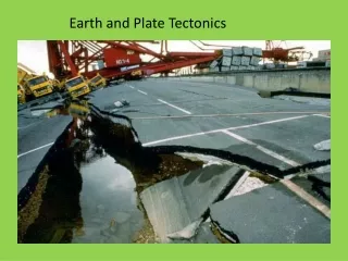
Plates & Quakes • An earthquake is the result of a sudden release of energy when rocks under stress slide abruptly past one another along a break in the Earth's crust (fault). • Most earthquakes occur where the large rigid plates that make up the outer shell of the Earth are in contact with one another.
Rodinia and Laurentia • Once upon a time, the world's landmass was a single large continent called Rodinia. Sometime around 750 million years ago, Rodinia began to split apart into smaller continents. One of these continents, Laurentia, was the ancestor of North America. When Rodinia began to split apart, a rift (split) in our region of Laurentia failed to open.
Reelfoot Rift • This rift was detected using geophysical instruments and was named the "Reelfoot Rift." The Reelfoot Rift extends from Illinois soutwest toward the Gulf of Mexico. Even though the Reelfoot Rift is called "inactive", the Reelfoot Rift continues to influence the central United States region. For example, the New Madrid Fault System lies within confines of the Reelfoot Rift. These faults are responsible for hundreds of earthquakes that occur in the central United States.
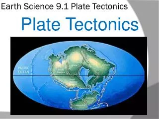
Theories regarding Plate Tectonics and Continental Drift • Panagea • Supercontinent that existed 200 million years aga
Panagea Then and now
Wegener’s Theory • In 1912, Alfred Wegener and Frank Taylor first proposed the theory that 200 million years ago the Earth had only one giant continent, from which today's continents broke apart and drifted into their current locations.
Evidence for Continental Drift • Wegener used the fit of the continents, the distribution of fossils, a similar sequence of rocks at numerous locations, ancient climates, and the apparent wandering of the Earth's polar regions to support his idea. • Continents as puzzle pieces • Fossil Evidence • Rock Evidence • Climate Evidence
The Shapes Match • The continents look as if they were pieces of a giant jigsaw puzzle that could fit together to make one giant super-continent. • The bulge of Africa fits the shape of the coast of North America while Brazil fits along the coast of Africa beneath the bulge.
The Plants and Animals Match • Wegener noted that plant fossils of late Paleozoic age found on several different continents were quite similar. • This suggests that they evolved together on a single large land mass. • Plant and animal fossils found on the matching coastlines of South America and Africa, which are now widely separated by the Atlantic
The Rocks Match • Broad belts of rocks in Africa and South America are the same type. • These broad belts then match when the end of the continents are joined.
The Ice Matches • Wegener was aware that continental ice sheet covered parts of South America, southern Africa, India, and southern Australia about 300 million years ago. Glacial striations on rocks show that glaciers moved from Africa toward the Atlantic Ocean and from the Atlantic Ocean onto South America. • Such glaciation is most likely if the Atlantic Ocean were missing and the continents joined.
Faulting • When an object is forced to go in a direction it was not meant to ge, it may fracture along the weakest lines of stress. These fractures are called faults.
Types of Faults • Normal Fault • Reverse Fault • Strike-Slip Fault