Download
1 / 1
10 likes | 86 Views
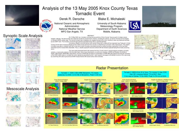
Analysis of the 13 May 2005 Knox County Texas Tornadic Event. Derek R. Deroche National Oceanic and Atmospheric Administration National Weather Service WFO San Angelo, TX. Blake E. Michaleski University of South Alabama Meteorology Program, Department of Earth Sciences Mobile, Alabama.

E N D
Analysis of the 13 May 2005 Knox County Texas Tornadic Event Derek R. Deroche National Oceanic and Atmospheric AdministrationNational Weather Service WFO San Angelo, TX Blake E. Michaleski University of South AlabamaMeteorology Program, Department of Earth SciencesMobile, Alabama Synoptic Scale Analysis ABSTRACT On 13 May 2005, two tornados occurred across portions of Knox County, Texas as part of a larger severe weather outbreak. The first tornado was observed visually by several storm chasers, including the authors, as well as remotely by the Doppler on Wheels (DOW) mobile radar. The second tornado was completely rain wrapped during its life cycle, therefore it was only observed remotely by the DOW team. The tornados moved through sparsely populated areas with no reported damage. Convective initiation occurred across north-central Texas with a supercell that originated near Paducah in Cottle County. As this storm moved southeast across Cottle County and into Knox County, it underwent an occlusion of the mesocyclone. The original circulation was able to maintain itself with a new storm scale circulation developing along the outflow boundary intersection of the rear-flank downdraft and the forward-flank downdraft. Thus, a ‘double supercell’ structure evolved with the forward supercell being the tornado-producing storm. The case study presented herein will examine the Knox County event in several aspects including a synoptic analysis, a mesoscale analysis of the boundary layer, direct visual observations, as well as an analysis of DOW and Weather Surveillance Radar-1988 Doppler (WSR-88D) observations. Access to DOW data will allow an examination of WSR-88D data against the finescale resolution of the DOW mobile radar to correlate the vortex signatures generated by both. Later research and papers will attempt to build on this case study by examining 30m above ground level DOW measurements with actual surface wind velocities. Radar Presentation Tornado 2: 0009 (6 km W of Vera, TX) moves S, then ESE, then SE, crossing Hefner, TX at 0037, then 5 km east of Goree, TX by 0052. Peak V=79 m/s at 0029. Tornado 1: 2340 (12km NNE Benjamin, TX) nearly stationary to 2346 (12 km NE of Benjamin), Peak V=49 m/s, Cross Sectional Analysis 2343 Z 13 May 2005 Doppler On Wheels 3 (DOW3) Analysis 2342 Z 13 May 2005 Cross Sectional Analysis 0040 – 0045 Z 13 May 2005 Doppler On Wheels 3 (DOW3) Analysis 0027 Z 13 May 2005 Mesoscale Analysis 0.5° 2-D X Sect Storm Relative Velocity 0.5° Base Reflectivity 0040 Z 0.5° Storm Relative Velocity 0040 Z 0.5° 2-D X Sect Storm Relative Velocity Edited Doppler Velocity Uncalibrated Reflectivity Edited Doppler Velocity Uncalibrated Reflectivity Edited Doppler Velocity Uncalibrated Reflectivity 0.5° Base Reflectivity Edited Doppler Velocity Uncalibrated Reflectivity 0045 Z 0.5° Base Reflectivity 0045 Z 0.5° 2-D X Sect Storm Relative Velocity 0.5° 2-D X Sect Base Reflectivity 0045 Z 0.5° Base Reflectivity 0.5° Base Reflectivity 0.5° 3-D X Sect Base Reflectivity Edited Doppler Velocity Uncalibrated Reflectivity 0045 Z 0.5° 3-D X Sect Storm Relative Velocity Edited Doppler Velocity Uncalibrated Reflectivity