Download
1 / 1
10 likes | 223 Views
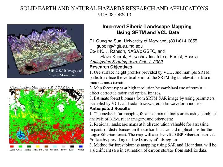
SOLID EARTH AND NATURAL HAZARDS RESEARCH AND APPLICATIONS NRA 98-OES-13. Product will be map/GIS layer of forage (wt) by area. Improved Siberia Landscape Mapping Using SRTM and VCL Data. PI. Guoqing Sun, University of Maryland, (301)614-6655 guoqing@glue.umd.edu

E N D
SOLID EARTH AND NATURAL HAZARDS RESEARCH AND APPLICATIONS NRA 98-OES-13 Product will be map/GIS layer of forage (wt) by area Improved Siberia Landscape Mapping Using SRTM and VCL Data PI. Guoqing Sun, University of Maryland, (301)614-6655 guoqing@glue.umd.edu Co-I: K. J. Ranson, NASA’c GSFC, and Slava Kharuk, Sukachev Institute of Forest, Russia Anticipated Starting date: Oct. 1, 2000 Research Objectives 1. Use surface height profiles provided by VCL , and multiple SRTM paths to reduce the vertical error of the SRTM digital elevation data in mountainous terrain. 2. Map forest types at high resolution by combined use of terrain- effect corrected radar and optical images. 3. Estimate forest biomass from SRTM SAR image by using parameters sampled by VCL, and radar backscatter, lidar waveform models. Anticipated Results 1. The methods for mapping forests at mountainous areas using combined analysis of DEM, radar imagery, and other data; 2. Regional landscape maps at high resolution valuable for assessing impacts of disturbances on the carbon balance and implications for the larger Siberian forest. The map will also benefit IGBP Siberian Transect Project by providing updated survey of this region. 3. Method for forest biomass mapping using SAR and Lidar data, will be a significant step in estimation of carbon storage from satellite data. SIR-C SAR Images of Sayani Mountains Classification Map from SIR-C SAR Data Decid Conif Sparse Mixture Clear Wetland Snow Rock Water