Download
1 / 24
240 likes | 334 Views
Weather Model Development for Aviation . Stan Benjamin and Steve Weygandt : Assimilation and Modeling Branch, Chief/Deputy NOAA Earth System Research Laboratory, Global Systems Division, Boulder, CO Stan/Steve: Lead/Expert

E N D
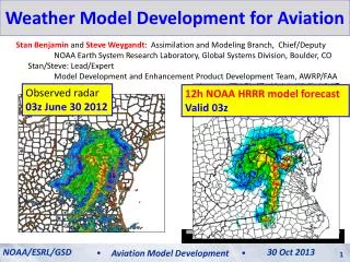
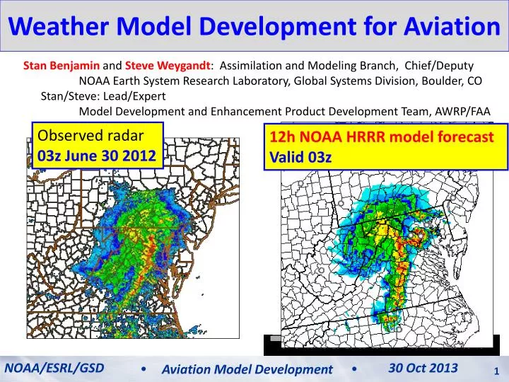
Weather Model Development for Aviation Stan Benjamin and Steve Weygandt: Assimilation and Modeling Branch, Chief/Deputy NOAA Earth System Research Laboratory, Global Systems Division, Boulder, CO Stan/Steve: Lead/Expert Model Development and Enhancement Product Development Team, AWRP/FAA Observed radar 03z June 30 2012 12h NOAA HRRR model forecast Valid 03z NOAA/ESRL/GSD 30 Oct 2013 Aviation Model Development
An Important Pinpoint Prediction Challenge: The 29 June 2012 Mid-Atlantic Derecho A fast-moving damaging wind event… Start HRRR run 11 AM 2 PM 4 PM 6 PM 8 PM 10 PM MID 700 mile long swath of damage, 5 million without power, 22 fatalities
Computer weather modeling: What is thepotential? 29 June 2012 – Mid-Atlantic/DC thunderstorm/derecho event HRRR 2012 derecho loop HRRR forecast initialized 15z (11am Eastern Time) Observed radar
Computer weather modeling: How is it done? 1800 points Model Equations 50- levels Weather computer model: Solve physics equations at many points repeatedly to mimic time-evolution of 3-D of temperature, wind, moisture, clouds, etc. 1060 points 1800 x 1060 points x 50 levels = 95,000,000 3-d points every 20 seconds Model Terrain
NOAA Next-Generation Model Development RAP • RAP - Rapid Refresh • NOAA “situational awareness” model for high impact weather • New 18-hour forecast each hour • NOAA operational – 1 May 2012 • Hourly use by National Weather Service, Storm Prediction Center, FAA, private sector • HRRR – High-Resolution Rapid Refresh • Next-generation storm/energy/aviation guidance • New 15-h forecast each hour • Real-time experimental on ESRL supercomputer • Open ftp access HRRR
RAPand HRRR data assimilation RAP Hourly cycling model EnKF- Hybrid + Radar and Cloud anx Radar and Cloud anx + 3DVAR Data Assimilation cycle Observations HRRR
Operational Prediction Process Data Assimilation Objective Analysis (adjust background) Observations AnalysisUpdateCycle Statistical post-processing (downscaling, probability) Model Prediction Human Forecaster
Rapid updating – Why do it? HRRR (and RAP) Future Milestones HRRR Milestones More frequent model updates with newer obs Smaller adjustments 12-h update to previous forecast Better forecasts 12-h fcst 9-h fcst 3-h update to previous forecast 6-h fcst 3-h fcst Truth Next forecast time noon 6 AM 9 AM 3 PM 6 PM
Rapid update cycling with latest observations improves short-range forecasts (including upper-level winds) Benefits of Rapid Cycling NWP 12-h fcst wind errors 3-h fcst wind errors 6-h fcst wind errors ORD ORD ORD LAX LAX LAX RUC jet-level (35 kft) wind forecast errors NOAA/ESRL/GSD 12 July 2012 NOAA/ESRL/GSD 30 Oct 2013 Aviation Model Development Aviation Model Development 9
RAP error reduction to 1-h forecast Rapid Refresh Wind forecast accuracy vs. forecast length 1h 6 3 12 18h 1 Jan - 7 Mar 2012 - Verification against weather balloon data The Rapid Refresh isable to use recent obs to improve forecast skill down to 1-h projection NCEP Production Suite Review NOAA/ESRL/GSD Rapid Refresh / HRRR 4-5 December 2012 30 Oct 2013 Aviation Model Development 10
Rapid RefreshHourly Update Cycle Partial cycle atmospheric fields – introduce GFS information 2x/day Cycle hydrometeors Fully cycle all land-sfc fields (soil temp, moisture, snow) 1-hr fcst 1-hr fcst 1-hr fcst Back- ground Fields Analysis Fields 3DVAR 3DVAR Obs Obs Time (UTC) 11 12 13
Observations assimilated in hourly updated models (Rapid Refresh)- All used to initialize 3km HRRR Radar reflectivity
High Resolution – Why do we need it? HRRR (and RAP) Future Milestones HRRR Milestones Thunderstorm ~3km horizontal resolution needed to “resolve” thunderstorms RAP HRRR
High Resolution – Why do we need it? HRRR (and RAP) Future Milestones HRRR Milestones Thunderstorm ~3km horizontal resolution needed to “resolve” thunderstorms ~3km horizontal resolution needed to “resolve” thunderstorms …but 4x resolution costs 64x computer power RAP HRRR
3-km HRRR – what it gets you... HRRR (and RAP) Future Milestones HRRR Milestones 13-km 6hr forecast HRRR 6hr forecast 13-km Resolution Parameterized Convection 3-km Resolution Explicit Convection 07 June 2012 ACCURATE STORM STRUCTURE ACCURATE ESTIMATE OF STORM PERMABILITY NO STORM STRUCTURE NO ESTIMATE OF STORM PERMEABILITY 5 PM EDT observed
Radar data assimilation: Getting storms in the right places Radar Obs 06:00z 18 May 2013 05z + 1 hour 1-hr fcstradar DA (13-km and 3-km) 1-hr fcstNO radar DA
Radar data assimilation: How it works for RAP and HRRR • Run model backwards in time (reversible processes only) • Run model forward in time (heating from radar observations) • Digital filter after backward and forward step -20 min -10 min Initial +10 min + 20 min NO backward step or filter for HRRR Backwards integration, no physics Forward integration,full physics with obs-based latent heating Initial fields with improved balance, storm-scale circulation RAP / HRRR model forecast
Radar data assimilation: How it works for RAP 00z init 00z 12 Aug 2011 Reflectivity RAP HRRR RADAR RAP HRRR no radar Convergence Cross-Section Rapid convective spin-up with radar data
Radar data assimilation: How it works for RAP +1 hr fcst 01z 12 Aug 2011 Reflectivity RAP HRRR RADAR RAP HRRR no radar Convergence Cross-Section Rapid convective spin-up with radar data
Cloud and Hydrometeor Analysis Adjust cycled explicit cloud fields using METAR and satellite data YES HM Hydrometeor designation from radar 29thConf on EIPT (IIPS) NOAA/ESRL/GSD High-Resolution Rapid Refresh 08 January 2013 30 Oct 2013 Aviation Model Development 20
Detailed, precise short-range weather guidance needed for: Rapid cycling NWP Data Assimilation and Rapid Cycling Numerical Weather Prediction (model) • Air transportation (NextGen) Data Assimilation Cycle • Required for improved weather guidance for: • Turbulence • Ceiling/visibility • Convective weather • Icing • Terminal/enroute weather • Safety and efficiency Observations
Aviation hazard forecasts – all based on RAP and HRRR models (out to 15-18h) Hourly updated 13km Rapid Refresh model forecasts (development supported by FAA/MDE, NOAA) Refreshing from latest observations every hour gives better accuracy
1800 points Subset of full domain Weather computer model: Solving physics equations on many points repeatedly to provide 3-D forecast forecast of temperature, wind, moisture, clouds, etc. 1060 points An example of computations needed 1800x1059x50 grid points = 95 E6 grid points x 50,000 floating pt ops per grid point = 4.75 E12 FPA / time step x 2160 time steps / 12h forecast = 10 E15 FPA / 12h forecast 10,000,000,000,000,000 calculations for one 12h HRRR CONUS forecast
RAP and HRRR Resources CW Overview Meeting NOAA/ESRL/GSD High-Resolution Rapid Refresh 12 June 2012 12 July 2012 NOAA/ESRL/GSD 30 Oct 2013 Aviation Model Development Aviation Model Development 24 24