Download

1 / 55
560 likes | 677 Views
Weather Model Development for Aviation. Stan Benjamin and Steve Weygandt : Assimilation and Modeling Branch, Chief/Deputy NOAA Earth System Research Laboratory, Global Systems Division, Boulder, CO Stan/Steve: Lead/Expert

E N D
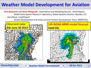
Weather Model Development for Aviation Stan Benjamin and Steve Weygandt: Assimilation and Modeling Branch, Chief/Deputy NOAA Earth System Research Laboratory, Global Systems Division, Boulder, CO Stan/Steve: Lead/Expert Model Development and Enhancement Product Development Team, AWRP/FAA Observed radar 03z June 30 2012 12h NOAA HRRR model forecast Valid 03z NOAA/ESRL/GSD 30 Oct 2013 Aviation Model Development
An Important Pinpoint Prediction Challenge: The 29 June 2012 Mid-Atlantic Derecho A fast-moving damaging wind event… Start HRRR run 11 AM 2 PM 4 PM 6 PM 8 PM 10 PM MID 700 mile long swath of damage, 5 million without power, 22 fatalities
Computer weather modeling: What is thepotential? 29 June 2012 – Mid-Atlantic/DC thunderstorm/derecho event HRRR 2012 derecho loop HRRR forecast initialized 15z (11am Eastern Time) Observed radar
Computer weather modeling: How is it done? 1800 points Model Equations 50- levels Weather computer model: Solve physics equations at many points repeatedly to mimic time-evolution of 3-D of temperature, wind, moisture, clouds, etc. 1060 points 1800 x 1060 points x 50 levels = 95,000,000 3-d points every 20 seconds Model Terrain
NOAA Next-Generation Model Development RAP • RAP - Rapid Refresh • NOAA “situational awareness” model for high impact weather • New 18-hour forecast each hour • NOAA operational – 1 May 2012 • Hourly use by National Weather Service, Storm Prediction Center, FAA, private sector • HRRR – High-Resolution Rapid Refresh • Next-generation storm/energy/aviation guidance • New 15-h forecast each hour • Real-time experimental on ESRL supercomputer • Open ftp access HRRR
RAPand HRRR data assimilation RAP Hourly cycling model EnKF- Hybrid + Radar and Cloud anx Radar and Cloud anx + 3DVAR Data Assimilation cycle Observations HRRR
Operational Prediction Process Data Assimilation Objective Analysis (adjust background) Observations AnalysisUpdateCycle Statistical post-processing (downscaling, probability) Model Prediction Human Forecaster
Rapid updating – Why do it? HRRR (and RAP) Future Milestones HRRR Milestones More frequent model updates with newer obs Smaller adjustments 12-h update to previous forecast Better forecasts 12-h fcst 9-h fcst 3-h update to previous forecast 6-h fcst 3-h fcst Truth Next forecast time noon 6 AM 9 AM 3 PM 6 PM
Rapid update cycling with latest observations improves short-range forecasts (including upper-level winds) Benefits of Rapid Cycling NWP 12-h fcst wind errors 3-h fcst wind errors 6-h fcst wind errors ORD ORD ORD LAX LAX LAX RUC jet-level (35 kft) wind forecast errors NOAA/ESRL/GSD 12 July 2012 NOAA/ESRL/GSD 30 Oct 2013 Aviation Model Development Aviation Model Development 9
RAP error reduction to 1-h forecast Rapid Refresh Wind forecast accuracy vs. forecast length 1h 6 3 12 18h 1 Jan - 7 Mar 2012 - Verification against weather balloon data The Rapid Refresh isable to use recent obs to improve forecast skill down to 1-h projection NCEP Production Suite Review NOAA/ESRL/GSD Rapid Refresh / HRRR 4-5 December 2012 30 Oct 2013 Aviation Model Development 10
Rapid RefreshHourly Update Cycle Partial cycle atmospheric fields – introduce GFS information 2x/day Cycle hydrometeors Fully cycle all land-sfc fields (soil temp, moisture, snow) 1-hr fcst 1-hr fcst 1-hr fcst Back- ground Fields Analysis Fields 3DVAR 3DVAR Obs Obs Time (UTC) 11 12 13
Observations assimilated in hourly updated models (Rapid Refresh)- All used to initialize 3km HRRR Radar reflectivity
High Resolution – Why do we need it? HRRR (and RAP) Future Milestones HRRR Milestones Thunderstorm ~3km horizontal resolution needed to “resolve” thunderstorms RAP HRRR
High Resolution – Why do we need it? HRRR (and RAP) Future Milestones HRRR Milestones Thunderstorm ~3km horizontal resolution needed to “resolve” thunderstorms ~3km horizontal resolution needed to “resolve” thunderstorms …but 4x resolution costs 64x computer power RAP HRRR
3-km HRRR – what it gets you... HRRR (and RAP) Future Milestones HRRR Milestones 13-km 6hr forecast HRRR 6hr forecast 13-km Resolution Parameterized Convection 3-km Resolution Explicit Convection 07 June 2012 ACCURATE STORM STRUCTURE ACCURATE ESTIMATE OF STORM PERMABILITY NO STORM STRUCTURE NO ESTIMATE OF STORM PERMEABILITY 5 PM EDT observed
Radar data assimilation: Getting storms in the right places Radar Obs 06:00z 18 May 2013 05z + 1 hour 1-hr fcstradar DA (13-km and 3-km) 1-hr fcstNO radar DA
Radar data assimilation: How it works for RAP and HRRR • Run model backwards in time (reversible processes only) • Run model forward in time (heating from radar observations) • Digital filter after backward and forward step -20 min -10 min Initial +10 min + 20 min NO backward step or filter for HRRR Backwards integration, no physics Forward integration,full physics with obs-based latent heating Initial fields with improved balance, storm-scale circulation RAP / HRRR model forecast
Radar data assimilation: How it works for RAP 00z init 00z 12 Aug 2011 Reflectivity RAP HRRR RADAR RAP HRRR no radar Convergence Cross-Section Rapid convective spin-up with radar data
Radar data assimilation: How it works for RAP +1 hr fcst 01z 12 Aug 2011 Reflectivity RAP HRRR RADAR RAP HRRR no radar Convergence Cross-Section Rapid convective spin-up with radar data
Cloud and Hydrometeor Analysis Adjust cycled explicit cloud fields using METAR and satellite data YES HM Hydrometeor designation from radar 29thConf on EIPT (IIPS) NOAA/ESRL/GSD High-Resolution Rapid Refresh 08 January 2013 30 Oct 2013 Aviation Model Development 20
Detailed, precise short-range weather guidance needed for: Rapid cycling NWP Data Assimilation and Rapid Cycling Numerical Weather Prediction (model) • Air transportation (NextGen) Data Assimilation Cycle • Required for improved weather guidance for: • Turbulence • Ceiling/visibility • Convective weather • Icing • Terminal/enroute weather • Safety and efficiency Observations
Aviation hazard forecasts – all based on RAP and HRRR models (out to 15-18h) Hourly updated 13km Rapid Refresh model forecasts (development supported by FAA/MDE, NOAA) Refreshing from latest observations every hour gives better accuracy
1800 points Subset of full domain Weather computer model: Solving physics equations on many points repeatedly to provide 3-D forecast forecast of temperature, wind, moisture, clouds, etc. 1060 points An example of computations needed 1800x1059x50 grid points = 95 E6 grid points x 50,000 floating pt ops per grid point = 4.75 E12 FPA / time step x 2160 time steps / 12h forecast = 10 E15 FPA / 12h forecast 10,000,000,000,000,000 calculations for one 12h HRRR CONUS forecast
RAP and HRRR Resources CW Overview Meeting NOAA/ESRL/GSD High-Resolution Rapid Refresh 12 June 2012 12 July 2012 NOAA/ESRL/GSD 30 Oct 2013 Aviation Model Development Aviation Model Development 24 24
RAP/HRRR Model Development and Eval HRRR (and RAP) Future Milestones HRRR Milestones ESRL/GSD/AMB NCEP Real-Time Retrospective RAP Retro RAPv2 Primary RAP Dev2 RAP Dev1 RAPv1 NCO FAA-CoSPA NWS-AWIPS HRRR Dev1 HRRR Primary HRRR Retro WEB RAP/HRRR internal verification NOAA/ESRL/GSD FPAW - 2013 RAP/HRRR Model Status 30 Oct 2013 24 October 2013 Aviation Model Development 25
HRRR Availability – getting it out HRRR (and RAP) Future Milestones HRRR Milestones HRRR 12 hr fcstavailability Includes all missed/incomplete runs CoSPA Evaluation Periods Development and Upgrade Periods 3 month running average NOAA/ESRL/GSD FPAW - 2013 RAP/HRRR Model Status 30 Oct 2013 24 October 2013 Aviation Model Development 26
HRRR Dual-Computer Availability HRRR (and RAP) Future Milestones HRRR Milestones HRRR 12 hr fcstavailability Includes all missed/incomplete runs Jet (HRRR primary) Zeus (HRRR backup) Jet or Zeus (union) NOAA/ESRL/GSD FPAW - 2013 RAP/HRRR Model Status 30 Oct 2013 24 October 2013 Aviation Model Development 27
HRRR Dual-Computer Availability HRRR (and RAP) Future Milestones HRRR Milestones HRRR 12 hr fcstavailability Excludes two (or fewer) consecutive missed/incomplete runs Jet (HRRR primary) Zeus (HRRR backup) Jet or Zeus (union) NOAA/ESRL/GSD FPAW - 2013 RAP/HRRR Model Status 30 Oct 2013 24 October 2013 Aviation Model Development 28
HRRR Aviation Websites HRRR (and RAP) Future Milestones HRRR Milestones http://rapidrefresh.noaa.gov/hrrraviation/ (hourly output) Feedback from AWC Aviation specific forecast fields: Convection(intensity and depth) Ceiling and Visibility Flight Rules Surface Wind Precip Type Snowfall http://rapidrefresh.noaa.gov/hrrraviation15min/ (sub-hourly output) NOAA/ESRL/GSD FPAW - 2013 RAP/HRRR Model Status 30 Oct 2013 24 October 2013 Aviation Model Development 29
HRRR Latency – getting it out fast HRRR (and RAP) Future Milestones HRRR Milestones 2013 HRRR changes permitted ~45 min reduction in latency CoSPAperiod CoSPAperiod 2012 CoSPA period 2013 CoSPA period +1:45 +2:30 CoSPA Evaluation Periods Development and Upgrade Periods 3 month running average FPAW - 2013 NOAA/ESRL/GSD RAP/HRRR Model Status 24 October 2013 30 Oct 2013 Aviation Model Development 30
2012HRRRInitialization from RAP 13z 14z 15z 13 km RAP Obs Obs Obs GSI 3D-VAR GSI 3D-VAR GSI 3D-VAR HM Obs HM Obs HM Obs GSI HM Anx GSI HM Anx GSI HM Anx 1 hr fcst 1 hr fcst Refl Obs Refl Obs Refl Obs Digital Filter Digital Filter Digital Filter 18 hr fcst 18 hr fcst 18 hr fcst 3-km Interp 3-km Interp 3-km Interp 3 km HRRR 15 hr fcst 15 hr fcst 15 hr fcst
2013HRRRInitialization from RAP 13 km RAP 13z 14z 15z GFS Ens GFS Ens GFS Ens Obs Obs Obs GSI Hybrid GSI Hybrid GSI Hybrid HM Obs HM Obs HM Obs GSI HM Anx GSI HM Anx GSI HM Anx 1 hr fcst 1 hr fcst Refl Obs Refl Obs Refl Obs Digital Filter Digital Filter Digital Filter 18 hr fcst 18 hr fcst 18 hr fcst Obs 1 hr pre-fcst 3-km Interp GSI 3D-VAR 3 km HRRR 45 min of reduced latency HMObs GSI HM Anx Refl Obs 15 hr fcst
3-km radar data assimilation: Eliminating the spin-up problem Radar Obs 05:00z 18 May 2013 05z + 0 min 0-hr fcst3-km radar DA 0-hr fcstNO 3-km radar DA
Improved 0-2 hr Convective Fcsts Radar Obs 05:15z 18 May 2013 05z + 15 min 15-min fcst3-km radar DA 15-min fcstNO 3-km radar DA FPAW - 2013 NOAA/ESRL/GSD RAP/HRRR Model Status 24 October 2013 30 Oct 2013 Aviation Model Development 34
Improved 0-2 hr Convective Fcsts Radar Obs 05:30z 18 May 2013 05z + 30 min 30-min fcst3-km radar DA 30-min fcstNO 3-km radar DA FPAW - 2013 NOAA/ESRL/GSD RAP/HRRR Model Status 24 October 2013 30 Oct 2013 Aviation Model Development 35
Improved 0-2 hr Convective Fcsts Radar Obs 05:45z 18 May 2013 05z + 45 min 45-min fcst3-km radar DA 45-min fcstNO 3-km radar DA FPAW - 2013 NOAA/ESRL/GSD RAP/HRRR Model Status 24 October 2013 30 Oct 2013 Aviation Model Development 36
Improved 0-2 hr Convective Fcsts Radar Obs 06:00z 18 May 2013 05z + 1 hour 1-hr fcst3-km radar DA 1-hr fcstNO 3-km radar DA FPAW - 2013 NOAA/ESRL/GSD RAP/HRRR Model Status 24 October 2013 30 Oct 2013 Aviation Model Development 37
Improved 0-2 hr Convective Fcsts Radar Obs 06:30z 18 May 2013 05z + 1:30 min 1-hr 30m fcst3-km radar DA 1-hr 30m fcstNO 3-km radar DA FPAW - 2013 RAP/HRRR Model Status 24 October 2013 NOAA/ESRL/GSD 30 Oct 2013 Aviation Model Development 38
Improved 0-2 hr Convective Fcsts Radar Obs 07:00z 18 May 2013 05z + 2hr min 2-hr fcst3-km radar DA 2-hr fcstNO 3-km radar DA FPAW - 2013 RAP/HRRR Model Status 24 October 2013
Improved 0-2 hr Convective Fcsts Radar Obs 08:00z 18 May 2013 05z + 3hr 3-hr fcst3-km radar DA 3-hr fcstNO 3-km radar DA FPAW - 2013 RAP/HRRR Model Status 24 October 2013
Continued HRRR Improvement in 2013 HRRR (and RAP) Future Milestones HRRR Milestones Critical Success Index (CSI) skill score Verification June 1- Sept. 30 (respective seasons) 2013 HRRR 2012 HRRR
HRRR use in CoSPA HRRR (and RAP) Future Milestones HRRR Milestones CoSPA: Collaborative effort: ESRL/GSD, NCAR/RAL, MIT/LL Provide 0-8 hr thunderstorm intensity and echo top guidance to aviation community HRRR15 UTC 08 July 2011 6 hr forecast valid 21 UTC CoSPA17 UTC 08 July 2011 4 hr forecast valid 21 UTC Observation Valid 21 UTC 08 July 2011 VIL Blend with CIWS Echo Top FPAW - 2013 RAP/HRRR Model Status 24 October 2013
Time-lagged Ensemble Forecasts valid 21-22z 27 April 2011 Forecasts valid 22-23z 27 April 2011 10-11 hr fcst 11-12 hr fcst HRRR 11z Init 09-10 hr fcst 10-11 hr fcst HRRR 12z Init 08-09 hr fcst 09-10 hr fcst HRRR 13z Init Spatial radius 45 km Time radius 1 hr UH threshold 25 m2/s2 All six forecasts combined to form probabilities valid 22z 27 April 2011
Example: 28 August 2013 Convection develops in NYC terminal areas around 16 UTC FPAW - 2013 RAP/HRRR Model Status 24 October 2013
HRRR Conv Prob Fcst (HCPF) 02 hr fcst valid 16z 28 Aug 2013 Convective coverage now over much of extreme E PA and NJ Probability exceeds 40% Obsvalid 16z 28 Aug 2013 FPAW - 2013 RAP/HRRR Model Status 24 October 2013
Aviation hazard forecasts – all based on RAP and HRRR models (out to 15-18h) Hourly updated 13km Rapid Refresh model forecasts (development supported by FAA/MDE, NOAA) Refreshing from latest observations every hour gives better accuracy
HRRR Transition to NCEP • 2013 - early 2014 – 2 computers running identical HRRR (and RAPv2) – interim solution • Boulder – computer 1 • Fairmont, WV – computer 2 • Expected reliability at 98.5-99% via coordination of downtimes for Boulder vs. Fairmont computers • 2014 – NCEP running RAPv2 (FYQ1) and HRRR (FYQ2) • RAPv2 running in NCEP/NCO testing now • Effort underway to begin testing HRRR at NCEP FPAW - 2013 RAP/HRRR Model Status 24 October 2013
NCEP ESRL
Forecast NOAA’s Current NWP Model Production Suite Oceans HYCOM WaveWatch III Climate CFS Coupled Hurricane GFDL HWRF MOM3 ~2B Obs/Day Mostly Satellite +Radar Dispersion ARL’s HYSPLIT North American Mesoscale WRF NMM Global Forecast System Global Data Assimilation Severe Weather WRF NMM WRF ARW Short-Range Ensemble Forecast North American Ensemble Forecast System WRF: NMM+ARW ETA, RSM Air Quality GFS, Canadian Global Model NAM+CMAQ Rapid Refresh for Aviation, Severe Weather, Energy NCEP overview
History – NCEP (NMC) Implementations of FAA-funded high-frequency models with aviation focus • 1994 First operational implementation of RUC • 60km resolution, 3-h cycle • 1998 40km resolution, 1-h cycle, • Cloud physics, land-surface model • 2002 20km resolution • GOES cloud data assimilation • 2003 Change to 3dVAR analysis for improved assimilation • 2005 13km resolution New observation types (METAR cloud, GPS-PW, new cloud physics) • 2008Assimof radar reflectivity, mesonet winds, • 2012 WRF/GSI-based Rapid Refresh (RAP) replaced RUC • 2013 (Dec) RAP version 2 – improved storm environment • 2014 (Mar) HRRR version 1 – 3km