Download
1 / 17
170 likes | 328 Views
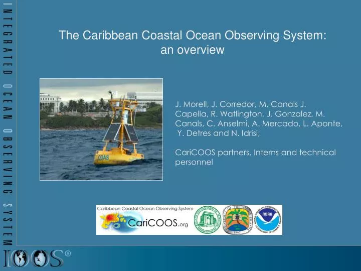
The Caribbean Coastal Ocean Observing System : an overview. J. Morell, J. Corredor, M. Canals J. Capella, R . Watlington, J. Gonzalez , M. Canals, C. Anselmi , A. Mercado, L. Aponte, Y. Detres and N. Idrisi, CariCOOS partners, Interns and technical personnel.

E N D
The Caribbean Coastal Ocean Observing System: an overview • J. Morell, J. Corredor, M. Canals J. • Capella, R. Watlington, J. Gonzalez, M. Canals, C. Anselmi, A. Mercado, L. Aponte, • Y. Detres and N. Idrisi, • CariCOOS partners, Interns and technical personnel
U.S. IOOS®, Integrated Ocean Observing System • Safety:IOOS helps ensure the safety and security of citizens. • Economy:IOOS unlocks economic and business benefits of the ocean. • Environment:IOOS is the key to protecting our environment for generations to come. Regional Subsystem (RCOOS): CONNECTIONS TO USERS & STAKEHOLDERS EXPANDED OBSERVATIONS & MODELS Alaska (AOOS) Caribbean (CaRA) Central and N. California (CeNCOOS) Gulf of Mexico (GCOOS) Great LakesObservingSystem (GLOS) Mid-Atlantic (MARACOOS) NorthwestPacific (NANOOS) NortheasternAtlantic (NERACOOS) PacificIslands (PacIOOS) Southern California (SCCOOS) SoutheastAtlantic (SECOORA)
High-Priority Observational and Forecast Needs identified through need assessments across all SH sectors • Coastal winds • Coastal waves • Coastal currents • Coastal inundation • Water quality (pathogens, visibility, sediments plumes) • Bathymetry (navigation, inundation and wave models) • Temperature & salinity (climate change, river input) • Benthic habitats
CariCOOS system design • optimum number of assets @ critical & spatially representative locations • modeling component (supporting now and forecast) • leverage for multiple purpose assets (HF radar, PWC surveyingsystem)
Coastal winds Observations:13 hurricane hardened meteorological stations in collaboration with WeatherFlowInc. 2 PRSN stations and 3 met stations aboard buoys Forecasting: Implementation of WRF @ 4 km resolution, collaboration with NWS
Coastal waves • unprecedented coastal • wave observations at CariCOOS Buoys: • (Triaxyssensors) and at the Rincon wave buoy • (Datawell) operated in collaboration with CDIP • forecasts using SWAN (Simulating WAveNearshore) • boundary conditions provided by NOAA WW 3 • support “virtual buoy deployments” ● ● ● ● ● 1000m resolution 55m
Coastal circulation (currents) • In situ current profiles at CariCOOS buoys A , B & C • CODAR surface currents for the Mona Passage (CSR-Rutgers, C. Fuller, A&M)
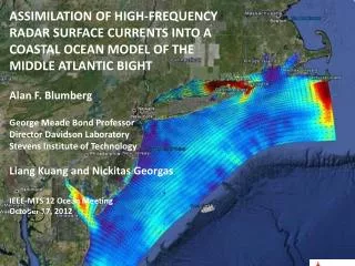
Circulationmodeling • Nearshore current: • ADCIRC near-shore currents • Operational regional ocean models: • Navy IASNFS and NCOM-AMSEAS & NOAA RTOFS • AMSEAShas highest regional resolution, output plotted and served by CariCOOS daily • Regional HYCOM-ROMS under development. ADCIRC Coastal Circulation AMSEAS Output
Coastal Inundation by storm surge • Implementation and validation of PADSWAN • Cat 1,2 and 5 available (5 approach bearings, 10nm between tracks) San Felipe (aka Okeechobee) Cat 5 Hurricane 1928. 1836 deaths in Florida 312 in Puerto Rico.
Remotely sensed water quality products Development and delivery of WQ products based on remotely sensed optical properties for watershed management, recreational activities (turbidity, visibility, CDOM content)
Data, products & caricoos.org • Data: • pushed to MADIS & NDBC • archived • published as products for various levels of expertise (caricoos.org) Meteorological Data Ingest System, National data Buoy Center
Outreach and Education Data product dissemination and assessment : • EDUCATION PLAN • Informal education through web tutorials, • Inclusion into school curricula Outreach and Education Committee
Where do we go from here? • Keep doing what we are doing !!!! • and • MOVE INSHORE • Implementation of high resolution observing/ modeling tools and products in support of: • maritime and recreational operations • coastal hazard mitigation • coastal zone management • plume dynamics • rip/alongshore and near-shore currents • beach erosion • port security and recuperation • spatial planning - MPA designation/validation • storm surge plus rain (CI-Flow)
Marine Recreation • rip and alongshore currents • beach water quality • diver visibility (a) • Instantaneous surface elevation (m) at Jobos beach, one of the most dangerous beaches in PR. • (b) Wave-induced currents from BOUSS2D depict, for the first time, the current patterns responsible for numerous drownings.
Port operations: currents & winds Charlotte Amalie San Juan Harbor waves 4.5 m. Hs (significant wave height) 10s period, 9 m/s wind speed (Apr-08)
Coastalmanagement / hazards • Implementation of USACE’s • Coastal Modeling System for addressing beach dynamics (erosion deposition etc) • Collaboration in the development of Coastal and Marine Spatial Planning tools • enhance inundation products including VI domain(PADSWAN) • facilitate regional participation in CI-FLOW • technological security and port recuperation • bathymetric survey system • rapid response for spill trajectory estimation