Download
1 / 6
60 likes | 179 Views
WCP. Created By The Weather Control Panel weathercontrolpanel.webs.com.

E N D
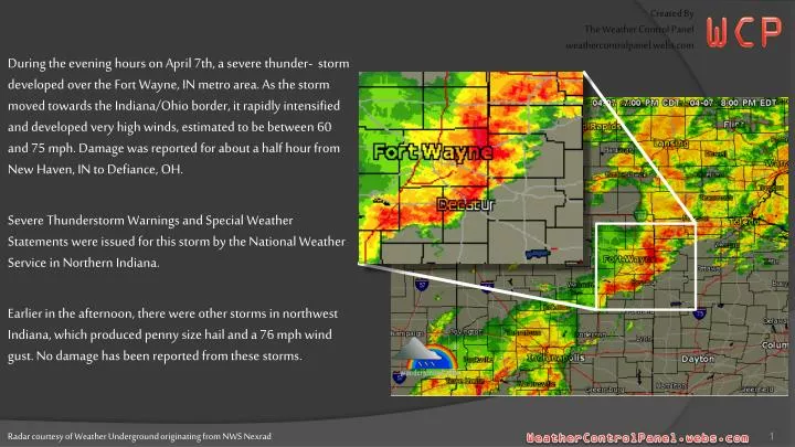
WCP Created By The Weather Control Panel weathercontrolpanel.webs.com During the evening hours on April 7th, a severe thunder- storm developed over the Fort Wayne, IN metro area. As the storm moved towards the Indiana/Ohio border, it rapidly intensified and developed very high winds, estimated to be between 60 and 75 mph. Damage was reported for about a half hour from New Haven, IN to Defiance, OH. Severe Thunderstorm Warnings and Special Weather Statements were issued for this storm by the National Weather Service in Northern Indiana. Earlier in the afternoon, there were other storms in northwest Indiana, which produced penny size hail and a 76 mph wind gust. No damage has been reported from these storms. Radar courtesy of Weather Underground originating from NWS Nexrad
Base Radial Velocity 0.50 Degree Elevation Range 124 NMI Storm Relative Mean Radial Velocity 0.50 Degree Elevation Range 124 NMI New Haven, IN – Shortly Before 8pm EDT The Glenbridge Manor Mobile Home Park was damaged. One mobile home was blown off its foundation, causing a gas leak. There were several other mobile homes that suffered minor damage. No one was reported to be injured. There were also several other reports of power lines and trees down throughout New Haven. One shed was blown 300 feet before slamming into a pole on the south side of Moeller Road, west of Hartzell Road. 60-70+ mph winds indicated by dark orange/brown shading Radar courtesy of Weather Underground originating from NWS Nexrad
New Haven, IN Trailer & Shed Damage Photos Photos courtesy of wane.com
Base Radial Velocity 0.50 Degree Elevation Range 124 NMI Storm Relative Mean Radial Velocity 0.50 Degree Elevation Range 124 NMI 3 miles NNE of Antwerp, OH - 8:06pm EDT Barn door was damaged. 60-70+ mph winds indicated by dark orange/brown shading Radar courtesy of Weather Underground originating from NWS Nexrad
Base Radial Velocity 0.50 Degree Elevation Range 124 NMI Storm Relative Mean Radial Velocity 0.50 Degree Elevation Range 124 NMI 1 mile north of Cecil, OH - 8:14pm EDT Mobile home off its foundation with a person trapped inside briefly. Double wide mobile home was rolled over, and another trailer and a home suffered some damage. A power pole snapped at the ground, and a pole barn was destroyed. Also, a large tree was down just south of this location. No injuries were reported. 60-70+ mph winds indicated by dark orange/brown shading Radar courtesy of Weather Underground originating from NWS Nexrad
Base Radial Velocity 0.50 Degree Elevation Range 124 NMI Storm Relative Mean Radial Velocity 0.50 Degree Elevation Range 124 NMI Defiance, OH - 8:20pm EDT Trees and power lines down across the county, especially in southern areas. 60-70+ mph winds indicated by dark orange/brown shading Radar courtesy of Weather Underground originating from NWS Nexrad