Download
1 / 28
280 likes | 283 Views
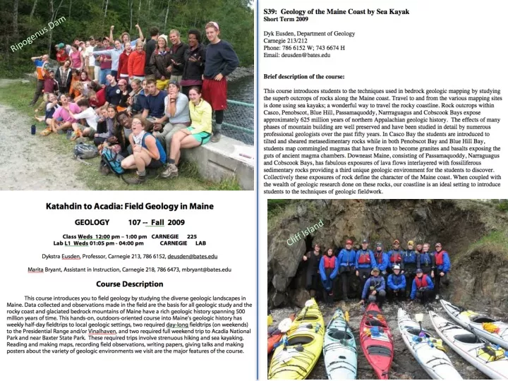
Ripogenus Dam. Cliff Island. GEO 107 “Field Geology in Maine” 12 week fall semester course. GEO s39 “Geology of the Maine Coast by Sea Kayak” 5 week course in May. Ripogenus Dam. Falls Island. Acadia N. P. Tourmaline mine in Paris. Roque Islands. Pond and Douglas Islands.

E N D
Ripogenus Dam Cliff Island
GEO 107 “Field Geology in Maine” 12 week fall semester course GEO s39 “Geology of the Maine Coast by Sea Kayak” 5 week course in May Ripogenus Dam Falls Island Acadia N. P. Tourmaline mine in Paris Roque Islands Pond and Douglas Islands Reid S. P.. Vinalhaven Yarmouth Island Isle au Haut Georges Islands Cliff Island
S39: Geology of the Maine Coast by Sea Kayak • 2009 • Dyk Eusden, Department of Geology • 786 6152, deusden@bates.edu, 212 Carnegie Important things and dates: This is an extra cost short term, approx $ 1,500 per student. Submit the application form to me before the end of the first week of winter semester if you want to enroll in this short term. Deadline for financial aid application is January 19, 2009. Financial aid award decisions are made on February 2, 2009. Registration for extra cost short terms, February 7-13, 2009.
Cliff Island – Metasedimentary rocks, tilted, good starting project Isle Au Haut – Commingled intrusive igneous rocks, “think like a fluid” Roque Islands – Volcanic lava flows, sills, and fossiliferous sedimentary rocks, more difficult, much of it previously unmapped Roque Islands Isle Au Haut Cliff
Mesozoic Basalt Dike Ordovician Scarboro Formation Ordovician Spring Point Formation Magnetite + garnet granofels Ordovician Cape Elizabeth Formation Ordovician Cushing Formation
Finished geologic map of Cliff Island made in ArcMAP and Adobe InDesign
Commingling of two magmatic fluids; one granitic the other gabbroic
Gabbroic pillows Pegmatitic pipes
Hickey Island Geology of the Roque Island Archipelago Halifax Island Marsh Island Little Spruce Island
Roque Islands Geology Overview • Late Silurian, Early Devonian • Double subduction zone • Basalt lava flows • Pyroclastic flows, ash tuffs • Sedimentary shales and slitstones with fossils • Faults Where we’ll be… From the student’s PPT
So, why teach field methods this way? Hands-on, experiential, outdoor education to complement the normal indoor setting. Complete experience: diverse geologic environments, low impact-leave no trace, kayaking–navigation skills, weather, group dynamics. An introduction to Maine bedrock geology and field methods through its natural settings. Gives students a sense of place. It is rewarding, adventurous, and fun. Students love it.