Download
1 / 78
790 likes | 1k Views
NORTH AFRICA AND SOUTHWEST ASIA. Geography 200 Dr. Stavros Constantinou. NORTH AFRICA AND SOUTHWEST ASIA.

E N D
NORTH AFRICA AND SOUTHWEST ASIA Geography 200 Dr. Stavros Constantinou
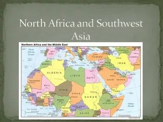
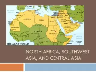
NORTH AFRICA AND SOUTHWEST ASIA • This region is often referred to as the Middle East, a term that is an inaccurate reflection of colonial chauvinism and a reflection of the eurocentric view of the world. The “Middle East” is about halfway along the route to the "Far East" from Britain or France. Applying the same logic, to the inhabitant of Pakistan, this region would have been described as "Midwest." • The geographically correct term Southwest Asia, will be used here despite the fact that it creates problems because we often tend to include China, India, and Japan. • Also, there is a problem regarding the incorporation of Saudi Arabia or Israel. Egypt is clearly more related to Syria or Iraq than those nations are to Korea or Vietnam. Geographically Egypt belongs to Africa. The nations north of the Sahara Desert share many similarities with the "Middle East" but relatively few with their neighbors in Sub-Saharan Africa.
NORTH AFRICA AND SOUTHWEST ASIA • From the political geographer's point of view, this region constitutes a shatter belt, that is, a fragmented region, coveted by outside powers, where the dangers of confrontation are great, the stakes are high, and the dangers of escalating conflict all too real. Conflict has been more or less endemic to this region throughout recorded history. Several flash points continue to persist down to the present time. • Despite its diversity, this region constitutes a unit because of: • a. the dominance of dry climates and • b. the Islamic (Moslem or Muslim) religion. Islam is the principal religion in all countries except: • Israel, where Judaism prevails; • Lebanon, where ancient forms of Christianity are of major importance.
NORTH AFRICA AND SOUTHWEST ASIA: MAJOR FEATURES • Dry climates and the Muslim faith dominate in this region. • More than sixty percent of the world's oil reserves are found here. • The Fertile Crescent was one the major domestication hearths extending from the Levant to the Persian Gulf. Crops originating here include figs, grapes, dates, and olives. • Home to three of the world's major religions: Judaism, Christianity, and Islam. • Water is the most important resource in the area and population is concentrated where water is found. Water is not only the basis for life, but for the social organization of the village. • The Middle East is one of the world's shatterbelts and a focal point of conflict.
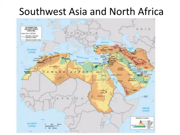
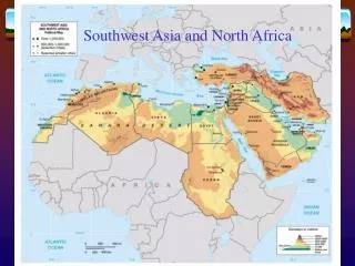
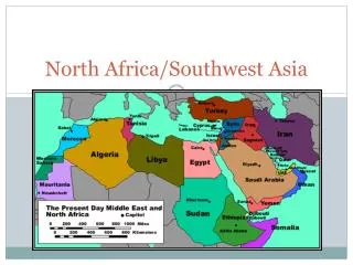
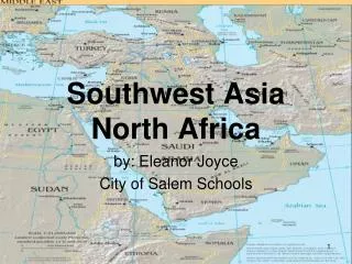
NORTH AFRICA AND SOUTHWEST ASIA: LOCATION AND SIZE • The realm of North Africa and Southwest Asia forms an elongated region stretching for 9,660 km. (6,000 mi.) across northern Africa and southwestern Asia, from the Atlantic Ocean to the borders of India, China and Central Asia. • This realm covers an area of 16,886,155 square kilometers (6,519,752 square miles) or 11.3% of the total land area of the planet. • The Tropic of Cancer crosses the central section of this region. Turkey is the only country of this region that reaches along the 42nd parallel.
NORTH AFRICA AND SOUTHWEST ASIA: LOCATION AND SIZE • Twelve countries in this region have populations of 10,000,000 people or more. • Iran, Turkey, and Egypt have more than 60,000,000; • Iraq, Afghanistan, Uzbekistan, Morocco, Saudi Arabia and Algeria have populations that range between 24,000,000 and 32,000,000. • These countries have populations that range between 10 and 20 million: Syria, Yemen, Kazakhstan, and Saudi Arabia. • Western Sahara, Qatar and Bahrain are the smallest countries in population with 300,000, 600,000 and 700,000 people, respectively.
NORTH AFRICA AND SOUTHWEST ASIA: LOCATION AND SIZE • The importance of countries, however, is not necessarily a function of size. For example, the small state of Israel has carved out a niche for itself despite the opposition of larger neighbors. • The rich petroleum deposits of Kuwait and other minor territories of the Persian Gulf have magnified the importance of these small political units.
NORTH AFRICA AND SOUTHWEST ASIA: LANDFORMS • The margins of North Africa and Southwest Asia are mainly occupied by oceans, seas, high mountains, and deserts: • to the west, the Atlantic Ocean; • to the south, the Sahara Desert, the highlands of East Africa, and the Indian Ocean; • to the north, the Mediterranean, Black, and Caspian Seas together with mountains and deserts in Central Asia.
NORTH AFRICA AND SOUTHWEST ASIA: LANDFORMS • Alpine System: • A chain of mountains extends across Southwest Asia from the Toros (Taurus) ranges of Turkey to Zagros, Elburz, and Hindu Kush. • The Atlas Mountains of North Africa, the physiographic base of the settled Maghreb (Algeria, Morocco and Tunisia), are also a part of the Alpine System. The Atlas Mountains receive an average rainfall of 750 mm (30 inches), something unusual for this region. The role of altitude is clear. Even 240 km (150 miles) into the interior, the slopes of the Atlas receive more than 250 mm (10 inches) of rainfall.
NORTH AFRICA AND SOUTHWEST ASIA: LANDFORMS • In Iran, qanat (kanat) furnishes the water supply for a large share of the country's irrigated acreage. Qanat is an underground channel which carries irrigation water from the mountains, where rainfall is relatively plentiful, to the drier areas below. A qanat’s course may be clearly recognized from the air, for at intervals it has circular openings resembling miniature craters. It corresponds to the foggara of North Africa. The length of a qanat ranges from a few hundred meters to tens of kilometers. • Another important physiographic feature of this region is the elevated plain (plateau) of interior Iran, and the Anatolian Plateau of interior Turkey.
NORTH AFRICA AND SOUTHWEST ASIA: LANDFORMS • Sedimentary Covers: • This is a broad area extending from the Atlantic Ocean to the Delta of the Nile. • It also occupies major sections of the Arabian Peninsula, Syria, and Iraq. • Specifically, it includes the Sahara, Libyan, An Nafud, and Rub al Khali. • The Sahara forms the world's largest desert (9,065,000 sq. km. or 3,500,000 sq. mi.). It continues to move southward into Africa at a rate of about 8 km (5 mi.) per year. Such a spread of desert landscapes constitutes what is often referred to as desertification.
NORTH AFRICA AND SOUTHWEST ASIA: LANDFORMS • Rifted Shield Areas. • This is an elongated area that extends from the foothills of the Toros (Taurus) Mountains in Turkey, to the Jordan River Valley, and the Red Sea. • The best-known example of a rift valley is the one that extends from Syria, Israel, Jordan, and East Africa for more than 4,800 km (3,000 mi.) in length. • This rift valley includes the Sea of Galilee, the valley of the Jordan River, the Dead Sea, the Gulf of Aqaba, the Red Sea, and runs through Lake Rudolph and several smaller lakes to Lake Malawi with a branch through Lakes Tanganyika, Edward, and Albert.
NORTH AFRICA AND SOUTHWEST ASIA: CLIMATE • Because of the Arabian peninsula's location between 15 degrees and 30 degrees N lat., it is dominated by the subtropical high (STH) pressure throughout much of the year resulting in conditions of heat and especially drought. • Summer temperatures in this region often exceed 48º Celsius (120º Fahrenheit), while high humidity along the coasts adds to human discomfort. • Desert lands in this region typically have a high daily range of temperature. • Precipitation averages only between 5 and 10 cm (2-4 in.) except on the mountains (orographic effect) notably the arid regions of the southwest where as much as 76 cm (30 in.) of rain may fall.
NORTH AFRICA AND SOUTHWEST ASIA: CLIMATE Climatic types: • Tropical and subtropical desert (BWh). • Tropical and subtropical steppe (BSh). • Middle latitude steppe (BSk). • Dry summer subtropical or Mediterranean (Csa).
NORTH AFRICA AND SOUTHWEST ASIA: VEGETATION • Sparse desert vegetation predominates throughout this region. • Needleleaf evergreen trees are found in the Atlas Mountains of northwestern Africa. • Broadleaf evergreen trees are found in the Nile Valley. • Mixed: broadleaf deciduous and needleleaf evergreen trees are found in Northern coastal and eastern Turkey, and northern and western Iran.
NORTH AFRICA AND SOUTHWEST ASIA: SOILS The soils of this region are very poor. • The predominant soil group is the aridisols. • Patches of entisols are also found in the dry desert areas. • Inceptisols predominate in the river valleys and in northwestern Africa. • A small area of mollisols is found in the interior of the Anatolian Plateau in Turkey.
NORTH AFRICA AND SOUTHWEST ASIA: RESOURCES • Water has been the key to life in this arid environment, since the beginning of time. • For example, the ancient Greek scholar Herodotus described Egypt as “the gift of the Nile,” an evaluation that rings true today as it did in ancient times. • The Nile is an example of an exotic river because it receives its water as runoff in humid regions or from highland zones and then flows across large expanses of desert before reaching the Mediterranean Sea. • Along 2% of the Egyptian territory (Nile Valley and Delta) live more than 95% of the Egyptian population (72,100,000 in 2003). • Other examples of exotic river systems are the Tigris-Euphrates system and the Jordan River.
NORTH AFRICA AND SOUTHWEST ASIA: RESOURCES • The nomads of this region move from oasis to oasis in search of water and pastures for survival. • Oases are natural concentrations of fresh water that do not depend on immediate local precipitation, and they have proved critical for an important component of desert life. • In Iran, the qanat has been an integral part of life for a long time. The qanat is a subterranean channel built to carry irrigation water from mountains to the lands below. • In recent years, technology has been employed by many of the countries in this realm to solve the scarcity of water and supply drinking water for their people. For example, through the use of desalinationKuwait has a capacity of producing more than 600,000,000 liters of drinking water every day. Several cities along the Gulf depend on these practices for their survival.
NORTH AFRICA AND SOUTHWEST ASIA: RESOOURCES -- OIL • Oil is certainly the most important resource of North Africa and southwest Asia. Deposits are concentrated around the Persian Gulf. It is the most economically important export of the realm. • During the period 1994-1996, on average, these countries together produced 28.0 percent of the world total output. • Saudi Arabia ranked as the world’s leading producer with 13.1 percent followed by: Iran with 5.8 percent; the United Arab Emirates with 3.6 percent; Kuwait with 3.3 percent; and Libya with 2.2 percent (Table 6.2). • Additional detailed statistics on the world’s leading oil countries are shown in Table 6.3. • In 1997, the world estimates in petroleum reserves were 1,160,069,500,000,000 barrels. • These countries collectively account for 56.3percent of the world's total reserves. Saudi Arabia has 22.6 percent, Iraq 9.7 percent, Kuwait 8.2 percent, Iran 7.8 percent, U.A.E. 5.5 percent, and Libya 2.5 percent.
NORTH AFRICA AND SOUTHWEST ASIA: RESOURCES • In 1960, Venezuela, Iran, Iraq, Kuwait, and Saudi Arabia founded OPEC (Organization of Petroleum Exporting Countries) in an effort to dictate oil prices. • Later additions included Algeria, Ecuador, Nigeria, Gabon, Indonesia, United Arab Emirates, Qatar, and Libya. • This 13-member cartel was designed to control world pricing and production of a single commodity, oil. • Currently, OPEC has 11 members after the withdrawal of Ecuador and Gabon.
NORTH AFRICA AND SOUTHWEST ASIA: RESOURCES • This region has important natural gas deposits. • Collectively, these countries control 35.0% of the world's reserves in natural gas. • Of the world output, Iran ranks first with 15.0%, Qatar ranks third with 5.1%, U.A.E. has 4.1%, Saudi Arabia has 3.8%, Iraq has 2.4%, Algeria 2.6%, Uzbekistan 2.1%, and Turkmenistan has 2.0%.
NORTH AFRICA AND SOUTHWEST ASIA: RESOURCES • Chief among the mineral resources of the region are chromite and phosphate of lime. • Kazakhstan produces 16.8% of the world’s chromite and ranks second (after South Africa which produces 37.7 percent). Turkey ranks third producing 12.8% of the world’s chrome. • Phosphate rock is used in the manufacture of fertilizer. Morocco and Tunisia are among the world's leading producers of phosphate rock, 15.5 percent and 5.1 percent, respectively. Morocco ranks third and Tunisia fourth in the production of phosphate rock, after the United States (33.2 percent) and China (16.4 percent). Morocco is the world's leading exporter of this commodity. • Kazakhstan has 17.6 percent of the world’s uranium reserves and ranks second after Australia.
NORTH AFRICA AND SOUTHWEST ASIA: POPULATION • The twenty-seven countries that are included in the North Africa and Southwest Asia realm have a total population of 488,800,000, or 7.7% of the world total population. • The largest countries in terms of population are Turkey, Iran, and Egypt. These three countries together account for about half this total. • Population growth rates are, for the most part, higher than the world average. A number of countries in this region face a serious demographic problem if appropriate policies are not implemented to curb a population explosion. • Examples: • Egypt where the rate of natural increase of the population stands at 2.1 percent. • The rate of natural increase in the Palestinian Authority region stands at 3.6%, which is well above the world rate.
NORTH AFRICA AND SOUTHWEST ASIA: POPULATION • For the most part, the people of this region live along river valleys (Nile Valley and the valleys of the Tigris and Euphrates) and in the better irrigated lands. • The greatest density of population is found in a narrow strip of well-watered land along the Nile. • Egypt's population (about 95 percent) is highly concentrated in a narrow strip along the Nile and its delta. • Except for a few major cities, the majority of the population resides in small rural villages. • Egypt has one of the world’s highest physiologicpopulation densities, or number of persons per square unit of cultivated land. • While the overall arithmeticpopulation density of the country is 72 persons per sq. km (186 persons per sq. mi), the physiologic density is 1,839 persons/sq. km (4,764 persons per sq. mi).
NORTH AFRICA AND SOUTHWEST ASIA: POPULATION • An ecological trilogy characterizes most of the societies of the Middle East. Society is divided into three mutually dependent types of communities--the city, the village, and the tribe--each operating in a different setting, each contributing to the support of the other two sectors and thereby to the maintenance of total society. • (English, P. 1967. "Urbanites, Peasants and Nomads: The Middle Eastern Ecological Trilogy." Journal of Geography 66: 54-59).
NORTH AFRICA AND SOUTHWEST ASIA: URBAN GEOGRAPHY • While urbanization has been going on for a long period of time in this region, currently there are sixteen cities that have populations greater than one million inhabitants. • Istanbul, Tehran, and Cairo are the three largest cities of this region, with populations in excess of 6,000,000 inhabitants. • Because of the accelerated movement of people to the major urban centers of this region, a large number of people are forced to live in shantytowns that have sprung up in many of North Africa's and Southwest Asia’s cities. • For example, the poverty in Cairo's shantytowns is well publicized and in the major cities of the Maghreb the name bidonvilles is used to describe the poverty-stricken shantytowns that surround its cities.
NORTH AFRICA AND SOUTHWEST ASIA: URBAN GEOGRAPHY • Among the most important urban centers of this region is the city of Jerusalem (320,000), which is a holy place for three of the world’s major religions: Christianity, Judaism, and Islam. • Because all three religions have aspired to control Jerusalem, it is the focus of considerable problems in the Arab-Israeli conflict.
NORTH AFRICA AND SOUTHWEST ASIA: URBAN GEOGRAPHY • In Saudi Arabia, the government is developing new industrial towns at Jubail on the Gulf Coast and at Yanbu on the Red Sea. • Jubail is about halfway toward a planned population of approximately 300,000. • The city has major industrial zones, an airport, and highway linkages. • When completed, the city of Jubail will have the area of Greater London or Atlanta.
NORTH AFRICA AND SOUTHWEST ASIA: CULTURAL GEOGRAPHY • Religious complexity: • This region is the birthplace of the three great modern monotheistic religions of the world: Judaism, Christianity, and Islam. Monotheistic religions profess belief in only one God. • Jerusalem is the most sacred city to Jews and Christians; it falls behind only Mecca (Makkah) and Medina in sacredness for Muslims.
NORTH AFRICA AND SOUTHWEST ASIA: CULTURAL GEOGRAPHY • Judaism • The Jewish faith was given a spatial expression in 1948 with the formation of the state of Israel. • Diversity and disagreement exist in Israel. • European Jews, “Ashkenazim,” are not the same people as Middle Eastern “Sephardic” Jews. • Reformed and Orthodox versions of the Jewish faith are often in bitter doctrinal opposition. • Jewish fundamentalism is becoming increasingly visible.
NORTH AFRICA AND SOUTHWEST ASIA: CULTURAL GEOGRAPHY • Islam is the religion founded by the prophet Mohammed. • Muslims are adherents of the Islamic faith. There are about 1.1 billion Muslims in the world. Indonesia has the world’s largest Muslim population. • The term Islam means submission to the will of God (Allah). • The term shari’a refers to the form of government and laws required by adherence to the Koran, the Islamic holy book. • This major world religion originated in 610 A.D., when Mohammed began to receive visions from Allah's messenger, Gabriel, while meditating in a cave near Mecca. • The messages of Gabriel continued for twenty-two years and were recorded in the Koran. I
NORTH AFRICA AND SOUTHWEST ASIA: CULTURAL GEOGRAPHY • Islam: • In A.D. 622 Mohammed fled Mecca (idolatry and ritual were a profitable religious business in Mecca at the time) for Yathrib (later Medina--City of the Prophet). • This flight, or hegira, marks the beginning of the Moslem era. • Ten years later Mohammed ventured back to Mecca, where the idols were destroyed at the religious center of Kaaba, and the Islamic state began a phase of expansion diffusion.
NORTH AFRICA AND SOUTHWEST ASIA: CULTURAL GEOGRAPHY • There are five pillars in the Islamic faith: • Confession of faith by the acceptance of but one god, Allah, and his prophet Mohammed. • Dawn, noon, afternoon, sunset and nightfall prayers. • An almsgiving, or zaket, given to the needy. • Daytime fasting during the ninth lunar month, or Ramadan. • One pilgrimage, or hajj, to Mecca in a lifetime.
NORTH AFRICA AND SOUTHWEST ASIA: CULTURAL GEOGRAPHY • Following the death of Mohammed, his followers split into two major groups, based on whether succession to the prophet should follow elected lines or blood lines. • Muslims who believe in elected succession are called Sunni. • The Sunni are Orthodox Muslims who recognize the first four elected caliphs (successors of Muhammad as temporal and spiritual head of Islam) as the rightful successors to Muhammad. • Succession to Mohammed should be elective among senior leaders qualified to rule. • Sunni are the most numerous among the world's Muslims, accounting for about 85 percent of all Muslims.
NORTH AFRICA AND SOUTHWEST ASIA: CULTURAL GEOGRAPHY • Those who in bloodline succession are called Shi’iteand they are smaller in number than the Sunni. • According to the Shi’ites, the Prophet's succession should be hereditary. • They are a branch of Muslims that do not accept the election of caliphs, but recognize the "blood lines" of inheritance through Ali, one of Muhammad's nephews who had married the prophet's only surviving daughter. • The Shi’ites form the largest minority group of the Islamic world including Iraq and Pakistan. • They make up 90 percent of Iran’s Muslim population today. Only about 10 percent of the population of Iran is Sunni. • During the height of the holiest ceremony in the Shiah Muslim calendar, the streets are thronged with believers beating themselves with chains in mourning for Hussein, grandson of the Prophet, who was killed at Karbala in 680 A.D.
NORTH AFRICA AND SOUTHWEST ASIA: CULTURAL GEOGRAPHY • Among the smaller minorities of Muslims one can note the Ismailis and the Druses. • The head of the Ismailis, the Agha Khan, traces his ancestry back to the Prophet himself and his followers are located in northern Pakistan. • The Druses form a sect which includes elements of Christianity, Judaism and Islam and they are found chiefly in Lebanon and Syria. • In Oman, the Ibadhisect of Islam is the most important. • Islam spread throughout the North Africa / Southwest Asia region and became the dominant religion of the realm. • Arabs of North Africa and Southwest Asia account for only about one-fifth of the total Islamic population of the world.
NORTH AFRICA AND SOUTHWEST ASIA: CULTURAL GEOGRAPHY • Islam spread across central Asia, India, Malaysia and Indonesia; In China it spread as far as the city of Xian. • The Muslims of India constitute the world’s largest religious minority at about 120,000,000 people. • The spread of Islam occurred by a process of expansion diffusion – or the diffusion of an idea through a fixed population. • The expansion of Islam spread north into Spain, which was controlled by the Moors (an Arab- Berber alliance). Moorish influence is evident in Spanish architecture, including such landmarks as the palace of Alcazar and the Giralda in Seville, and also in the cities of Granada and Cordoba. • Indonesia, Pakistan and Bangladesh are the world’s largest Islamic countries. • Egypt, Turkey and Iran are the largest Islamic countries in North Africa / Southwest Asia. • The concepts of Islam are closely related to Judaic and Christian beliefs and traditions. In fact, Muslims honor the Jewish prophets and Jesus as holy men.
NORTH AFRICA AND SOUTHWEST ASIA: CULTURAL GEOGRAPHY Languages -- the linguistic picture in this region is very complex: • Semitic Family: • Arabic is the most widely used language in the North Africa and Southwest Asia realm. • Hebrew is spoken in Israel. • Amharic is spoken in the plateau country of Ethiopia. • AltaicFamily: • Turkic, a member of the of languages is spoken in Turkey. • Tajik • Indo-European Family: • Iranian (Farsi), is spoken in Iran. • Hamitic Family: • Berberic and Tuareg are spoken among the indigenous populations in Algeria and Morocco
NORTH AFRICA AND SOUTHWEST ASIA: ECONOMIC GEOGRAPHY • Agriculture: • Farming practices in this region are strongly correlated to the presence of water, the most important resource in this dry area. • The most productive areas are found along the allogenic (exotic) rivers of the Nile in Egypt and Tigris and Euphrates in Iraq. • Still smaller pockets of agricultural production are the areas adjacent to well-watered mountains and the coastal plains of countries like Turkey, which is self sufficient in foodstuffs. • The various oases are of smaller significance in the overall production of food.
NORTH AFRICA AND SOUTHWEST ASIA: ECONOMIC GEOGRAPHY • The improvements in agriculture are many in this region, undertaken in an effort to increase the amount of land under irrigation and raise larger amounts of food. • In ancient Egypt, basin irrigation was practiced. • According to this system, fields along the low bands of the Nile were partitioned off by earth ridges into a large number of artificial basins. • The mud-rich river waters would pour into these basins during flood time, and then the exits would be closed, so that the water would stand still, depositing its fertile load of alluvium. • Then, after six to eight weeks, the exit sluices were opened and the water drained away, leaving the rejuvenated soil ready for sowing.
NORTH AFRICA AND SOUTHWEST ASIA: ECONOMIC GEOGRAPHY • The most technologically advanced farming techniques are found in Israel where the employment of fertigation has indeed made the desert bloom. • Historically, agriculture in Israel is carried out in collectivized settlements called kibbutzim (singular, kibbutz). Many of the kibbutzim lie in frontier areas and perform defensive as well as agricultural and industrial functions. Far more numerous, however, are the small holder’s cooperatives called moshavim (singular moshav).
NORTH AFRICA AND SOUTHWEST ASIA: ECONOMIC GEOGRAPHY • In recent years, the construction of dams made possible the perennial irrigation of Egypt's farmlands. • The greatest of all Nile dam projects, the Aswan High Dam, was begun in 1958 and completed in 1971 at the First Cataract. • The dam wall is 110 meters (364 feet) high and creates Lake Nasser, one of the largest artificial lakes in the world. • The reservoir inundates 480 sq km (300 sq mi) of the Nile valley, not only in Upper Egypt, but also in the Sudan. • The cooperation of the Sudanese was required for construction of the dam, since 50,000 people had to be relocated.
NORTH AFRICA AND SOUTHWEST ASIA: ECONOMIC GEOGRAPHY • Prior to the building of Aswan, waters could irrigate 2.53 million hectares (6.25 million acres) of farmland. • To this area, the Aswan High Dam has added another 550,000 hectares 1 ha = 2.471 acres). • In addition, 400,000 hectares of farmland under basin irrigation could be converted to perennial irrigation resulting in increased crop yields. • Finally, the Aswan High Dam supplies Egypt with about 50% percent of its energy requirements in the form of hydroelectricity.
NORTH AFRICA AND SOUTHWEST ASIA: ECONOMIC GEOGRAPHY • In Upper and Middle Egypt the strip of green is five to 25 kilometers (three to 5 miles) wide. • Below Cairo, the Nile's delta is 160 kilometers (180 miles) long, and 250 kilometers (155 miles) wide (Alexandria to Port Said). • The waters of the delta are diverted through two controlled channels, the Rosetta in the west and the Damietta in the east. • Each distributary, as these channels are called, defines the delta of the Nile, and nearly half of Egypt's population inhabits the delta region
NORTH AFRICA AND SOUTHWEST ASIA: ECONOMIC GEOGRAPHY • The main agricultural crops that are produced in this region are: • Cotton from Egypt and Syria. • Cotton and cotton products form the major exports of Egypt. • Fruits and vegetables (which are important in all countries that have Mediterranean climate) • Cereals (especially barley) are raised in most of the less productive soils throughout the region. • In Egypt rice, millet, sugar cane and lentils are among the crops that thrive under perennial irrigation. • Tunisia has long been the world's leading exporter of olive oil. • Morocco exports citrus fruit and vegetables.
NORTH AFRICA AND SOUTHWEST ASIA: ECONOMIC GEOGRAPHY • Turkey's principal crops include: tobacco, hazelnuts (filberts) grown primarily in the Black Sea section, and grapes for sultana raisins and figs raised in the central Aegean section around the port of Izmir (Smyrna) with 1,757,414 inhabitants.
NORTH AFRICA AND SOUTHWEST ASIA: ECONOMIC GEOGRAPHY • Industry: • The industrial sector of these countries is mostly involved in the processing of food and light industries. • Turkey is a major exporter of textiles. • Pockets of heavy industry depend on the availability of local materials and are found in Egypt, Turkey and Israel. • A steel plant at Hulwan, near Cairo, uses the iron ore deposits found at about 50 km (30 miles) west of Aswan, manganese from the Eastern Desert and local limestone. • Israel produces an array of industrial goods with significant output in military hardware. • Israel is the world's leading producer in industrial diamonds.
NORTH AFRICA AND SOUTHWEST ASIA: POLITICAL GEOGRAPHY • Notwithstanding other conflicts in this region, the conflict between Israel and the surrounding Arab countries dominates the political geography of this area. • Israel was officially proclaimed on May 14, 1948; it borders on Lebanon and Syria to the north, Jordan to the east, Egypt to the southwest and the Mediterranean Sea to the west. • Following its creation Israel was involved in a war with the Arab populations living in Palestine, all of whom rejected Israel's right to exist. A large number of Palestinian Arabs became refugees.
NORTH AFRICA AND SOUTHWEST ASIA: POLITICAL GEOGRAPHY • The most important recent wars between Israel and the Arab countries are the following: • The failed Anglo-French intervention in the Suez Canal in collusion with Israel in 1956. • The Six-Day War in June 1967, when Israel emerged victorious and acquired major pieces of territory from Egypt (Gaza Strip and Sinai), Jordan (West Bank), and Syria (Golan Heights). Most of these areas are still disputed and have high population densities. • The Yom Kippur War of October 1973 during which the Egyptians were able to cross the Suez Canal. • Following peace negotiations at Camp David between Israel and Egypt, Israel returned the Sinai Peninsula to the Egyptians.