Download
1 / 11
110 likes | 236 Views
GOES Data Collection System. Eric Madsen Senior International Relations Specialist NOAA Satellite and Information Service December 4, 2009. What is GOES DCS?.

E N D
GOES Data Collection System Eric Madsen Senior International Relations Specialist NOAA Satellite and Information Service December 4, 2009
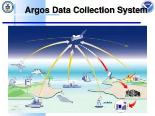
What is GOES DCS? • A GOES data service used for the collection of environmental data in real-time from > 30,000 remote data collection platforms located throughout the Western Hemisphere • Started as an experimental system for collecting real-time data that has evolved into a critical operational system used by many Federal, State, Local and International agencies • It has become the backbone of many agencies' real-time data collection programs • Many Emergency warning systems in the U.S. and other countries rely on GOES DCS NOAA GOES DCS
How Does it Work? • Frequency Share/Time Share System • 400 khz of Bandwidth Assigned to GOES DCS • Divided into Approximately 200 channels of 1.5 khz • Each Transmitter Assigned a Channel/Time Slot • Standard Assignment is Hourly, for 10 seconds • Some report more frequently (Tsunami Warning Stations) • Some older stations still report every 3 or 4 hours • Random Reporting Mode Available • Event Driven • Emergency Channel has more frequent observations • Flooding event, fire breakout, earthquake, volcano eruption NOAA GOES DCS
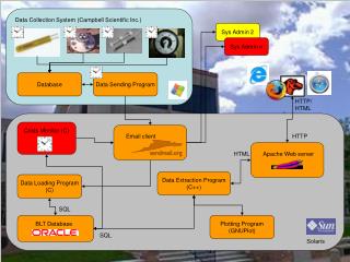
GOES DCS System Diagram NOAA GOES DCS
GOES DCS Users • Bureau of Reclamation • National Park Service • Department of State • (International Boundary & Water Commission) • Multiple State Agencies • Canadian Environmental Agencies • South and Central American Environmental Agencies • Total of over 400 agencies • National Weather Service • largest single data user • National Ocean Service • Declared DCS critical infrastructure • National Climatic Data Center • National Data Buoy Center • Pacific Tsunami Warning Center • US Army Corps of Engineers • US Air Force • US Navy • Department of Interior • National Interagency Fire Center • National Forest Service • Bureau of Land Management • US Geological Survey • largest single platform operator NOAA GOES DCS
Applications • Flood Warning • Levee Management • Water Resource Management • Fire Warning and Monitoring • Tsunami Warning • Earthquake Monitoring • Volcano Monitoring • Weather Observations • Climate Monitoring • Water Level Monitoring NOAA GOES DCS
Hazard Monitoring Uses • U.S. Fire Weather • Remote Automated Weather Station (RAWS) • Operated by USFS, BLM, state and local fire agencies • Estimated 4000 stations • National Standard for Fire Weather Data • Available through AWIPS • Available on the Internet • http://fire.boi.noaa.gov • http://raws.wrh.noaa.gov/rawsobs.html • http://www.fs.fed.us/raws NOAA GOES DCS
Hazard Monitoring Uses • U.S. Flood Data • USGS Stream Gauge Program • Approximately 10,000 stations • US Army Corps of Engineers Flood Monitoring • Approximately 3,000 stations • International Meteorological Services • Approximately 5,000 stations • Throughout North, Central and South America and the Caribbean and Pacific Islands • Distributed Through the NWS HADS • http://www.nws.noaa.gov/oh/hads/ NOAA GOES DCS
Water Applications • Approximately 70% of system usage is for water applications. • Flood Monitoring • Dam Monitoring • Reservoir Management • Tide gauges • Tsunami Warnings • Water Quality • Levee Management NOAA GOES DCS
System Improvements • New Transmitters use less time and frequency • High data rates already in use (300 and 1200 bps) • 100 bps transmitters must be replaced by June 2013 • Narrow band transmitters under development • Available in 2010 • Maybe software update • New data processing system to replace DAPS • DCS Administration and Data Delivery System (DADDS) • Self register at http://dcs1.noaa.gov • Internet access, browser based, 30 day archive • Beginning development for two way communication • Query and reprogram station remotely using GOES • (in 3 to 4 years) NOAA GOES DCS
GOES DCS Contact Information • Kay Metcalf • GOES DCS Program Manager • kay.metcalf@noaa.gov • 301-817-4558 • Letecia Reeves • GOES DCS Customer Service Representative • letecia.reeves@noaa.gov • 301-817-4563 • Email • goes.dcs@noaa.gov • URL • http://noaasis.noaa.gov/DCS NOAA GOES DCS