Download
1 / 15
160 likes | 331 Views
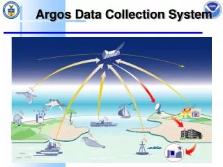
GOES DATA COLLECTION SYSTEM (DCS). KAY METCALF, GOES DCS PROGRAM MANAGER NOAA/NESDIS OFFICE OF SATELLITE DATA PROCESSING AND DISTRIBUTION. WHAT IS DCS?. Data Relay System Used for Transmission from Ground-Based Sensors through Satellite to Receiving Station.

E N D
GOES DATA COLLECTION SYSTEM (DCS) KAY METCALF, GOES DCS PROGRAM MANAGER NOAA/NESDIS OFFICE OF SATELLITE DATA PROCESSING AND DISTRIBUTION
WHAT IS DCS? Data Relay System Used for Transmission from Ground-Based Sensors through Satellite to Receiving Station. Carried on board NOAA Geostationary satellites since 1970’s.
GOES DCS USERS • Flood Monitoring • United States Geological Survey Water Resources Divison • U.S. Army Corps of Engineers • NOAA National Weather Service River Forecast Offices.
GOES DCS USERS (CONT) • Fire Monitoring • U.S. Forest Service • National Interagency Fire Center • Canadian and State Fire Agencies • Land Management • Bureau of Land Management
GOES DCS USERS (CONT) • Geologic Event Monitoring • United States Geological Survey Geologic Division • Earthquake Monitoring, Volcano Monitoring • NOAA/NWS/Tsunami Warning Center • Oceanographic Users • NOAA National Ocean Survey
GOES DCS USERS (CONT) • Resource Management • National, State, and Local Water Resource Managers • Meteorological Users • U.S. National Weather Service • International Hydromet Service facilities • Central America, South America, Pacific Islands, Mexico, Canada
SYSTEM USAGE ELIGIBILITY • GOVERNMENT USER • FEDERAL, STATE, LOCAL INTERNATIONAL. • ENVIRONMENTAL MEASUREMENT DATA • DATA OF INTEREST TO GOVERNMENT ENTITIES • DATA SHARED WITH OTHER GOVERNMENT USERS.
BENEFITS • Low-Cost • Low-Maintenance • Emergency Event-Driven Capability • Ideal for Remote Locations • Data Easily Shared Among Government Users
DRAWBACKS • Finite Capacity (Approximately 133 Domestic Self-Timed Channels) • Scheduled Transmissions based on Channel/Time Availability • Interference Detection Difficult • Troubleshooting capabilities Minimal
DATA DISSEMINATION METHODS • DCS AUTOMATED PROCESSING (DAPS) • Telnet or Dial-up Modem • DOMSAT (Commercial Communications Satellite) • DRGS (Direct Readout Ground System) • GTS (Global Telecommunications System) Network
ENHANCEMENTS • MORE EFFICIENT SYSTEM USE AGREEMENT • LESS PAPERWORK MEANS FASTER PROCESSING • “SUA” VERSUS “MOA” MAY MEAN LOWER USER APPROVAL LEVELS (I.E. FASTER PROCESSING) • BETTER TRACKING OF REQUESTS
ENHANCEMENTS • MORE INFORMATION AVAILABLE ON WEB PAGES • APPLICATION FOR SYSTEM USE AGREEMENT • REPORTS • GENERAL AND TECHNICAL INFORMATION • TROUBLE REPORT AND ASSIGNMENT REQUEST TEMPLATES
ENHANCEMENTS • High Data Rate Transmitters (300 or 1200 bps, compared to 100 bps) • GPS Clocks • Better Timing • Smaller Windows • Result: More Assignments
HDR STATUS • THREE MANUFACTURERS CERTIFIED TO SELL TRANSMITTERS • DEMODULATORS OPERATING SUCCESSFULLY • DEFICIT OF DEMODULATORS UNTIL FULL COMPLEMENT RECEIVED
CONTACT US • http://noaasis.noaa.gov/DCS • http://dcs.noaa.gov • goes.dcs@noaa.gov