Download
1 / 59
590 likes | 595 Views
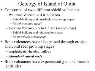
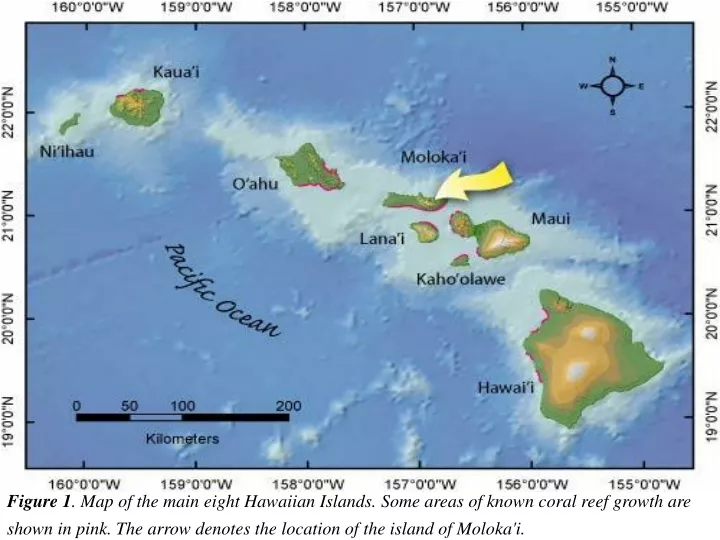
Figure 1 . Map of the main eight Hawaiian Islands. Some areas of known coral reef growth are shown in pink. The arrow denotes the location of the island of Moloka'i. Geology of Island of Moloka‘i. Formed by two large shield volcanoes: West Moloka‘i Volcano

E N D
Figure 1. Map of the main eight Hawaiian Islands. Some areas of known coral reef growth are shown in pink. The arrow denotes the location of the island of Moloka'i.
Geology of Island of Moloka‘i • Formed by two large shield volcanoes: • West Moloka‘i Volcano • Shield Stage, Lower Member, 1.8-1.5 Ma • typical tholeiitic basalts • no evidence for a caldera • Postshield Stage, Upper Member, age unknown • very small and thin • alkalic basalt and hawaiite • East Moloka‘i Volcano • Shield Stage, Lower Member, 1.8-1.5 Ma • typical tholeiitic basalts • Postshield Stage, Upper Member, 1.5-1.3 Ma • mugearite, an alkalic intermediate rock more silica-rich than hawaiite • Rejuvenation Stage? Kalaupapa Member, 0.6-0.3 Ma • alkalic basalt (not a very low silica lava like basanite) • a large portion of this volcano has been removed by a giant submarine landslide
Molokai - Landforms Reef
Maui Nui Maui Nui emerged 1.2 million years ago
Molokai was a part of the Maui Nui ‘Big Maui’ 1.2 million years - Pleistocene
Molokai Volcanic Island – Growth and life stages of two volcanoes 1.2-1 Ma 1.8-1.5 million years ago 1 Ma 800,00 years ago 500,000 years ago Present
Shield Volcano oldest youngest
The Friendly Isle of Moloka'i encompasses 673 sq km (260 sq mi), making it the fifth largest of the main eight Hawaiian Islands. The north and west coasts of the island have little coral growth due to impact from northwest swell. However, protected from the southern swell waves by the islands of Lana'i and Kaho'olowe, the south shore of Moloka'i boasts the longest continuous fringing reef of the U.S. and its holdings.
Kalaupapa Peninsula WestMoloka‘i Volcano EastMoloka‘i Volcano
Geology: Molokai’s roughly rectangular shape results from the coalescence of two separate shield volcanoes: the 1.9 million year old West Moloka'i Volcano, and the younger (appx. 1.75 million year old) East Moloka'i Volcano (Figure 1). To the southwest is Penguin Bank, a submarine platform lying at a depth of approximately 57 m (170 ft). It is suggested that Penguin Bank is either an offshore extension of the West Moloka'i rift zone, or a separate submerged shield volcano. Later in its life, the northeastern portion of the West Moloka'i Volcano collapsed into the ocean, leaving behind large slide scarps. Lava from the younger East Moloka'i Volcano flowed across the lowland of the Ho’olehua Saddle and terminated against the flank and slide scarps of the West Moloka'i Volcano. Near the end of its active volcanism, the northern flank of the East Moloka'i Volcano slid into the ocean leaving behind the towering pali (cliffs) on the northeast coast of the island (Figure 2).
East Molokai is the remnant of a great shield volcano shaped in map view like the bottom half of an ellipse split along its major axis. The bottom half or southern flank slopes gently to the sea in the typical manner of shield volcanoes. However, the northern flank of the ellipse has been truncated by great cliffs rising up to 900 meter (3,000 feet) above sea level. The cliffs of East Molokai's north shore are remnants of a much larger shield volcano whose northern flank had subsided along faults and disappeared beneath the sea. This submarine landslide, giant slump, is termed as Wailua Slump.
The sea cliffs of Molokai's north shore were formed when the northern third of the East Molokai Volcano suddenly collapsed and slid off into the sea. This was a geological event of cataclysmic proportions--involving about 600 cubic miles of island falling along a 25-mile long landslide that tumbled out as far as 120 miles offshore. The landslide was so fast and powerful that the last 80 miles of its 120-mile run was uphill, climbing 900 feet up from the Hawaiian Deep, the great depression caused by the weight of the islands. Displacement of this much material generated a 2,000-foot high tsunami that inundated the rest of Molokai and the nearby island of Lanai. Scientists date this geologic event at about 1,400,000 years ago.
source of magma (and explanation) not clear -extremely low degrees of partial melting (very alkalic) -very small overall volume of volcano -Molokai, Maui, Oahu Ko‘olau, Kaua‘i
Extent of the Wailau and Nuuanu Submarine Landslides. From Prodigious Submarine Landslides on the Hawaiian Ridge. J.D. Moore, et al. 1989.
Kauhako Volcano Kalaupapa Peninsula
Physiographic Map of East Molokai: The inner dotted line and black areas mark the edge of the caldera. The outer dotted line depicts the shoreline of East Molokai Volcano before the great Wailau Landslide. From The Caldera of East Molokai Volcano, Hawaiian Islands. Holcomb and Compton. 1985.
The Kalaupapa Peninsula, on the north central coast of Moloka'i, resulted from more recent volcanic activity when the Kauhako Crater erupted approximately 300,000 years ago. The Kalaupapa Peninsula is backed by the towering pali on one side and storm-battered coasts on the remaining sides. Its inaccessibility led to its being chosen by the Kingdom of Hawai'i as a settlement for people afflicted with Hansen’s Disease (leprosy). Bisecting the island, the broad Ho’olehua Saddle, composed of eroded sediment of the East and West Moloka'i Volcanoes, forms a low-lying coastal plain along the south shore. The southeastern edge of the island is bordered by an alluvial plain constructed from a series of semi-contiguous alluvial fans associated with upland gulches. Three of the broader areas, formed at the base of the three major gulches of Kaunakakai, Kawela, and Kamalo (Kamalo’o), have played important roles in early human settlement of the southeast coastline.
The island of Molokai presents a high contrast in the distribution of its water resources. Eastern Molokai with its more mountainous terrain has substantial water resources; whereas, western Molokai, with its lower elevation and relatively flat terrain, has a paucity of water resources. This imbalance, coupled with low soil fertility and high evaporation from the persistent northeast tradewinds, led to the construction of a transbasin water diversion system in 1961 to bring water from eastern to western Molokai. Molokai is part of Maui County. Maui County also encompasses the islands of Maui, Lanai and Kahoolawe. Molokai covers an area of about 260 square miles. The 1990 census population for Molokai was 4,319 (Kanaukakai, 2,658 and Kualapu'u, 1,661). The present population is estimated to be about 7,000 and is predominantly rural. Kaunakakai, located about midway along Molokai's south coast, is the island's major population and commercial center. Small communities and rural Hawaiian Homestead settlements are located in the central part of the island. The more mountainous eastern half of the island remains unpopulated, except for scattered residences and a few commercial establishments along the southern coast.
The deep loose soils, the presence of streams and springs, the low, irregular shoreline, and the relative protection and resources of the broad reef platform provided an inviting physical environment for early human occupation in the southeastern coastal area. Early Hawaiians took advantage of the natural system to develop a regime of coastal activities duplicated nowhere else in Hawai’i.
Digital Elevation Model (DEM) of Moloka‘i and color-coded oblique view looking northwestward
Penguin Bank • Shield volcano • Broad shoal that has subsided 57m below sea level • Covered with carbonate bank • Once connected to Moloka’i when Moloka’i was a part of Maui Nui • Submerged within the last 100,000 years
Longest stretch of white sand beach in the state of Hawai’I Over 3 miles long and 300 feet wide Sand supplied from mo’omomi sand dunes Papohaku
Molokai, a high volcanic island in the Hawaii Isles chain, is 62 km (E–W) long and 13 km wide (N–S). Formed predominantly by two volcanoes, East Molokai (1.8 million years old) and West Molokai (1.9 million years old). Molokai is the fifth-largest island in the main HawaiianIslands. Created by the Hawaiian hotspot, Molokai is isolated from tectonic influences associated with continental and plate boundaries. Deformation of the lithosphere by volcanic loading at the hotspot, however, induces some vertical motion among the main islands. However, no evidence has documented conclusively whether Molokai is stable, emerging, or submerging through time. At roughly 21 N, 157 W, Molokai lies between Oahu and Maui and is protected on the south shore by the most extensive coral–algal fringing reef among the main HawaiianIslands
Oblique closeup view of the seafloor looking west toward Pailolo Channel, between Maui (on left) and Molokai (on right). The modern reef platform (A) is in red and orange colors. The older drowned reef (B) is at 400 m depth. The drowned reef front rises 30 m above the seafloor to the north. The scale across the bottom of the image is 7.8 km. The vertical exaggeration is 5x.http://walrus.wr.usgs.gov/pacmaps/mi-fig9.html
Figure 5. Landsat satellite image overlaid with the benthic habitat classification map of Moloka'i showing the Dominant Structure/Substrate layer and the percentage of each class.U.S. Geological Survey Open File Report 2005-1070 Version 1.0 Moloka'i Benthic Habitat Mapping By Susan A. Cochran-Marquez USGS Pacific Science Center Santa Cruz, CA http://pubs.usgs.gov/of/2005/1070/
Moloka'i has sites with the best coral coverage in the main eight Hawaiian Islands. the spectacular north shore cliffs from Kalaupapa to the Halawa Valley, East Molokai.. http://www.nps.gov/pwro/piso/minkstdy/nscliffC.htm
Moloka'i’s Coral Reef System The fringing coral reef tract along Moloka'i’s south shore consists of three distinct parts: 1) inner reef flat; 2) reef crest; and, 3) outer fore reef (Figure 3). Sedimentation and natural processes vary significantly between these environments. The inner reef flat, lying in shallow water nearest the shoreline, is a relatively level, broad platform and the first to be influenced by terrestrial sedimentation and runoff. The reef crest is the zone where waves impinge and commonly break. Water depth is extremely shallow over the reef crest (less than 1 m), and it is occasionally exposed during very low tides. The outer fore reef slopes seaward from the reef crest to depths of about 35 m (105 ft), and corals grow abundantly to depths of about 25 m (83 ft). From a depth of 14 m (45 ft) to 25 m (83 ft), the Moloka'i reef has a typical spurand- groove morphology. Reef spurs (buttresses) are oriented shore perpendicular and are separated by broad grooves (channels) which transport sand offshore. Live coral grows on the spurs, and commonly in the grooves as well; relief is on the order of 1 to 3 m (3.5 to 10 ft).
Figure 3. Schematic diagram (top) of typical fringing reef tract. Aerial photograph (below) showing the approximate locations of the inner reef flat, reef crest, and outer forereef on Moloka'i.
The North Shore Cliffs from the Kalawao scenic overlook in Kalaupapa National Historic Park.
March 6, 2008 : Mokapu rises to a narrow ridge 360 feet above sea level and supports some of the best native coastal plant habitat in Hawai'i, including 29 native plant species An unprecedented eradication project on the tiny islet Mokapu off north Moloka'i is making rats more scarce than the rare native plants and seabirds on which they feast. Last month's aerial dropping of rodenticide pellets on the 10-acre state seabird sanctuary was the first of its kind for Hawai'i's offshore islands. http://www.honoluluadvertiser.com/apps/pbcs.dll/article?AID=/20080307/NEWS14/803070361/1025/NEWS14
Near the Pelekunu Valley in May 1999, a major landslide occurred along the North Shore Cliff.
Relict clumps of Brighamia rockii survive on sea cliffs inaccessible to goats.
On this rat-free sea stack along Molokai's north shore a relict Prichardia palm forest still survives.
Lands within Kalaupapa NHP consist of the relatively flat Makanalua peninsula, three interior valleys and the rim of the adjacent cliffs or pali. The volcanic eruption that created the peninsula was a more recent geological event than the formation of the island of Molokai. The small shield volcano, Pu'u 'Uao, gave birth to the peninsula by forming the Kalaupapa shield. This feature is the most recent evidence of volcanism on Molokai, occurring in the late Pleistocene. The rest of the park, more than half, is part of the main shield volcano of the island of Molokai and geologically distinct from the peninsula. It is comprised of the Wai'alie'a, Waihanau and Waikolu valleys and the spectacular pali rising more than 2,000 feet above the peninsula. Kalaupapa's pali is the westward extension of Molokai's north shore cliffs which extend all the way to the island's eastern end. The sea cliffs of the north shore of Molokai, because of their geological significance, have been designated a national natural landmark. Waikolu, the largest and easternmost of the three valleys within Kalaupapa, is similar in its geological, biological, ecological and archeological resources to the other windward valleys to the east--Pelekunu, Wailau, and Halawa. However, due to the long-term effects of transbasin diversions of its flow, the biological and ecological values of the Waikolu Stream have been compromised. These diversions were begun in 1961 and studies conducted since then estimate that they remove approximately 20 percent of the annual water yield from the Waikolu watershed.
Mean Sea Level Trend 1617760 Hilo, Hawaii The mean sea level trend is 3.36 millimeters/year (1.10 feet/century) with a standard error of 0.21 mm/yr based on monthly mean sea level data from 1927 to 1999
Mean Sea Level Trend 1615680 Kahului, Hawaii The mean sea level trend is 2.09 millimeters/year (0.69 feet/century) with a standard error of 0.43 mm/yr based on monthly mean sea level data from 1954 to 1999.
Mean Sea Level Trend 1612340 Honolulu, Hawaii The mean sea level trend is 1.5 millimeters/year (0.49 feet/century) with a standard error of 0.14 mm/yr based on monthly mean sea level data from 1905 to 1999.
Mean Sea Level Trend 1611400 Nawiliwili, Hawaii The mean sea level trend is 1.53 millimeters/year (0.50 feet/century) with a standard error of 0.38 mm/yr based on monthly mean sea level data from 1954 to 1999.
Mean Sea Level Trend 1612480 Mokuoloe, Hawaii The mean sea level trend is 1.12 millimeters/year (0.37 feet/century) with a standard error of 0.46 mm/yr based on monthly mean sea level data from 1957 to 1999.