Download
1 / 25
250 likes | 503 Views
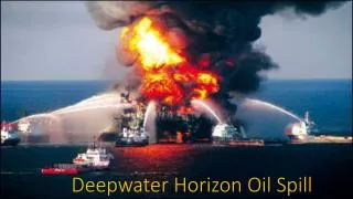
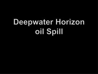
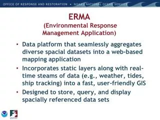
OR&R’s ERMA (Environmental Response Management Application) & NOAA’s Deepwater Horizon Spill Response . George Graettinger NOAA’s Ocean Service Office of Response & Restoration Presentation to Regional Response Team III Ocean City, MD September 14 th , 2010. ERMA. Overview

E N D
OR&R’s ERMA (Environmental Response Management Application) & NOAA’s Deepwater Horizon Spill Response George Graettinger NOAA’s Ocean Service Office of Response & Restoration Presentation to Regional Response Team III Ocean City, MD September 14th, 2010
ERMA • Overview • ERMA Conceptual design/model • Background and History • ERMA capabilities and development • DWH MC252 Response • ERMA Online demonstration • Key features • Next steps
Concept for ERMA Open Source, Web-based mapping tools Planning & Analysis Integrate & Analyze Information On the fly Improved Communication & Coordination
Goal of ERMA Implementation • Assist with response preparedness • Assist in coordinating response efforts • Define the extent of potential environmental impacts • Assist in Response, Recovery, and Restoration • Provide assistance in hours, not days!
Background/History • Identified need for Web based GIS system that can assist in environmental response efforts and operations (2006 – 2007) • ERMA developed by NOAA as a Pilot project in Portsmouth NH with regional stakeholders in 2008 (USGC, EPA, States, NGOs) • After successful testing and RRT drills in NH, Caribbean ERMA was developed as a joint response effort with EPA for the Caribbean RRT in early FY 2010 • Spill of National Significance (SONS) drill in March NOAA expanded the pilot project with assistance from regional stakeholders (ME-DEP, NH-DES, MA-DEP, EPA, and USCG) • ADM Allen designated ERMA as the Common Operational Picture (COP) for the Deepwater Horizon Incident June 2010
Current ERMA Development • New England (SONS) • Caribbean – US territories, but expanding upon interest • Puget Sound WA – Primarily for evaluating climate impacts but potential to expand • Pacific Islands in development • Arctic from NOAA OCRM Energy Initiative • Lake Champlain in development FY 11 (discussing expansion NJ/ NY harbor with EPA R2) • Great Lakes- Funding FY 11 Arctic Puget Sound WA Great Lakes Lake Champlain New England NJ/NY Harbor Gulf of Mexico Caribbean Pacific Is
Output to User Download/Upload Source ERMA Architecture Feature Server Tools ESI & IPAC Query AIS Ship Search Open Layers Web Mapping Service (Feature) • External GIS Data • ENCs/ RNCs • Real Time Weather Observations • Buoys • NAIS/ AFF/AMOC Secure Server Authentication Data Layer Management Access Privileges • Response datasets from SFTP • Trajectories • Satellite Interpretations for oil • SCAT Results • Overflight Planed & Oiling Observations • Booms plans/derived from imagery • Protected Resource Impact • Field sampling (subsurface, analytical chemistry, etc.) • Platform oiling observations MapServer • Base Public datasets • ESI • Landuse • Bathymetry • Regional Monitoring • Habitat Classifications • Restoration • Bioresource Base data Postgres/ PostGIS Database (Full Backup routinely)
ERMA GOMEX: Deployment Timeline GOMEX ERMA Available for ICP Data upload 4/22 ERMA integrated With FWS IPAC query tool MMSI zoom To ship functioncreated Deployed ERMA staff To ICPs data ingestion BP databasereplication SONS ExerciseMarch 23-25th Geoplatform.gov/ Gulfresponse Supporting Simple KML April MAY JUNE JULY August DWH BlowoutApril 20th Ingest of customdata feeds NAIS feed Filtered for Response NOAA sFTP site deployed Creation of Ship track tool webpage ERMA Populated With base GRP, ESI, Etc. 4/24 Getfeature info support ERMA down 2.5 hours power failure • Key to development timeline was ERMA Adaptability in scaling: • Open Source freeware software that was customizable • Had to completely clone backend software architecture to cloned databases after Geoplatform.gov release and redeployed overnight because 3.4 million hits on first day of launch • Ability to code for non OGC and customized vendor feeds
Internal & External ERMA • Response/NRDA ERMA • gomex2.erma.unh.edu • Internal, restricted access • Public ERMA • www.geoplatform.gov • External, un-restricted access • Controlled access • Development/ Strategic planning • Data Sharing and Public access
ERMA Capabilities • Readily accessible from any web browser by customized account access (IE 7+, Firefox, Safari, Chrome) • Simultaneous Updating of Data to single database • Uploads are location independent • Multiple users may add content at the same time • Ingest external OGC compliant data feeds (e.g. WMS, GeoRSS, now KML) • Developers Can Tailor Data Ingest • Non-OGC compliant data can be accommodated (SPOT, Geoforce, Lipsey, Outerlink) • Ingest authentication done server side (NAIS, AFF, USCG WMS)
Readily accessible via web browsers Standard symbolization Both general public & Secure access Username/Password Various levels of access (Public, Responder, NRDA) Incident information Trajectories Oiling Observations Asset tracking Field team locations SCAT data Sample collection & results ERMA Site Basics • Real-time feed • Weather, buoys, ship tracking, etc. • Resources at Risk • NOAA ESI data layers • State/Local habitat and species datasets • Fisheries Closures • Background Layers • Aerial, terrain, roads • Nautical charts • Document & photo links • ESI and GRPs PDFs • Field Photos • External links
Primary Source Response Daily Data Source Location Display Location Deep Water Horizon Data pushed into ERMA from various sources SFTP/ Replicate feed BP/ ICPs Task Force ERMA Responder Decon locations/ Waste Area BP/ ICPs Replicate feed ERMA Responder BP/ ICPs ERMA Responder Emergency Response Teams Replicate feed BP/ICPs Beach Cleanup ERMA Responder SFTP/ Replicate feed BP/ ICPs Field Boom Data ERMA Responder SFTP/ Replicate feed BP/ ICPs Burn/ Dispersant ERMA Responder SFTP/ Replicate feed BP/ ICPs WEBEOC/ Phone log ERMA Responder Replicate feed? BP Platform Observations SFTP NOAA ERMA Responder ERMA Public NESDIS Anomaly Analysis SFTP NOAA ERMA Responder ERMA Public Fishery Closures SFTP NOAA Trajectories ERMA Responder SFTP ERMA Public NOAA Protected Resources Impacts ERMA Public SFTP ERMA Responder NOAA Loop Current SFTP ERMA Responder ERMA Public NOAA Subsurface Monitoring SFTP ERMA Responder ERMA Public* NOAA Helo Oil Obs & Photos SFTP ERMA Responder NOAA/ University Buoy/ AXBT Data ERMA Public FTP ERMA Responder NOAA/ BP SCAT Obs and Photos SFTP ERMA Responder ERMA Public* BP/ ICPs VOOs tracking Modified WMS ERMA Responder USCG NAIS Feed Modified WMS ERMA Public* ERMA Responder IRSCC Planned Remote Sensing Email KML ERMA Responder AFS/ AMOC Air Operations Feed Modified WMS ERMA Responder NGA NGA Satellite Analysis SFTP ERMA Responder NGA Imagery Derived Booms NGA SFTP * Slightly modified for public EPA SFTP/WMS Monitoring data
Public display of fish closures, potential oil footprint and shore impacts on May 29th, 2010
Public display of response asset locations and weather feeds
ERMA DWH Lessons Learned • Non-technical Interface • GIS background not necessary to navigate • “How to” sessions in command posts to socialize ease of use • Success Story – quote from NIC staff “You should see ADM Allen fly around ERMA on the touch table” • Scalable Access • Quick to stand up foundation • Public Facing data needed- Geoplatform.gov/Gulfresponse • Varying data access levels based on account type (responder , NRDA, Trustee) • Cost Effective due to Open Source Software • Customizable Programming & Modular development • Public Facing or specialized sites (Climate Change, Marine Debris, Tsunami, Fire)
ERMA DWH Lessons Learned • Customization & Flexibility is key • Vessel tracking and asset customization • Plug & Play with other systems • All systems need to be OGC compliant • ESRI 9.3 WMS don’t provide legend graphics or static rest WMS • Support various data formats (WMS, GeoRSS, KML, etc) • Expansion of Tool Capabilities (IPAC & other agency tool integration, AOI points, Labels, etc.) • Additional Functionality • Auto-refresh • Ship Search • Customized reports • Download data for other GIS project ingestion
ERMA DWH Lessons Learned • Collaboration is required • Need to leverage existing resources & data for application buy in • Multiple Government Agencies • USEPA • USCG • USFWS • NGA • Private Sector • BP & contractors • Google • Imagery service & Investigating 3-D display potential • Telascience- Fast mosaic for tile cache imagery • ESRI - hosted WMS for public consumption • NPS • LA FWS & DEQ • MS FWS & Disaster Plan • FL Disaster Plan
NOAA Next Steps for ERMA • Continue customization of ERMA for DWH and future sites • Leverage ties with Google for potential 3-D rendering and enhancements for KML ingestion • Animation requests for data layers (Beta Release) • Complete outreach and training materials • Apply lessons learned from DWH to Caribbean Site • Stand alone version (not reliant on web) • Work with EPA and RRT2 for site development in NY/NJ • Development in Pacific Islands, Great Lakes, Arctic with stakeholders (USCG, EPA, States & NGOs)
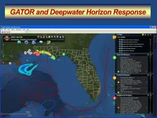
ERMA Demonstrationgomex2.erma.unh.edu • Key Features- • General layout, control, and contents • Find • Zoom (Including MMSI search) • Shapefile download • Bookmarks/Slideshow • Feature Animation • ESI Query Tools • Metadata links (FGDC and “lite metadata”)