1 / 0

Environmental Response Management Application In the Arctic

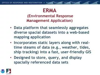
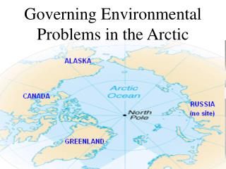
Environmental Response Management Application In the Arctic . ®. Amy Merten , Kari Sheets, Celeste Leroux , Zach Winters- Staszak NOAA’s Office of Response and Restoration. Fairbanks, AK September 10, 2013. Environmental Response Management Application (ERMA ® ). Functions

oakley
Download Presentation

Environmental Response Management Application In the Arctic

An Image/Link below is provided (as is) to download presentation Download Policy: Content on the Website is provided to you AS IS for your information and personal use and may not be sold / licensed / shared on other websites without getting consent from its author. Content is provided to you AS IS for your information and personal use only. Download presentation by click this link. While downloading, if for some reason you are not able to download a presentation, the publisher may have deleted the file from their server. During download, if you can't get a presentation, the file might be deleted by the publisher.

E N D

Presentation Transcript


  1. Environmental Response Management Application In the Arctic ® Amy Merten, Kari Sheets, Celeste Leroux, Zach Winters-Staszak NOAA’s Office of Response and Restoration Fairbanks, AK September 10, 2013
  2. Environmental Response Management Application (ERMA®) Functions Web-based mapping tool Analyze and visualize environmental information Prepare for, respond to, assess impacts from hazardous incidents or conditions Increases communication, coordination, and efficiency Website (launched for public use July 31, 2012) https://www.erma.unh.edu/arctic
  3. Uses of ERMA Purpose is to integrate and synthesize environmental data into a single interactive map via a Web interface from anywhere Data visualization- Not a data management system or data archive for everything ORR does ERMA Data goes across ORR spectrum from spill to NRDA and Restoration Restoration - Recovery (Years to Decades) Response (24 hours) (NMFS/ Partners) (ERD) (ARD)
  4. ERMA Schematic View
  5. Output to User Download/Upload Source Tools ERMA Architecture Feature Server Drawing/ Labels Custom Data Reports Open Layers Web Mapping Service/ Feature Ship Search & Zoom Data Query & Summary Download External GIS Data Nautical Chart Real Time Weather Obs Buoy data feeds Vessel Tracking NOAA Baseline Datasets Secure Server Authentication Data Layer Management Access Privileges Secure Response datasets Trajectories Satellite Interpretations for oil Shoreline Assessment Results Overflight Plans & Observation Booms Strategies & Deployment Protected Resource Impacts Field sampling (subsurface, analytical chemistry, etc.) Platform observations Additional data feeds as required MapServer Base Public datasets Environmental Sensitivity Indices Landuse Bathymetry Regional Monitoring Habitat Classifications Restoration Projects Local Bioresource data PostGres/ PostGIS Data Base (Full Backup routinely) Blue denotes Open Source Software
  6. Geographic Response Plans
  7. National Ice Center: Ice Extent Feeds
  8. National Weather Service: Ice Concentration
  9. Subsistence and Traditional Knowledge in ERMA A series of communications…. 1) Major stakeholder workshop (Anchorage, AK), 2011 2) Northwest Arctic Borough, (Kotzebue, AK), 2012 All 11 Villages Participated 3) North Slope Borough (Barrow, AK), 2012 All 8 Villages Participated 4) University of Alaska Fairbanks, 2013 (Wainwright/Barrow) 5) Inuvialuit Region (Edmonton, AB), 2013
  10. Stand Alone Arctic ERMA In the Arctic, limited communications infrastructure could be a major hindrance to effective incident response Stand Alone functionality allows the set-up of ERMA in a command post or remote location without Internet Financial support provided by BSEE for development Completed, and ready for field testing. Testing onboard USCGC Healy “Arctic Shield” drill/cruise Sept 7- 21st, 2013
  11. Arctic Shield 2013 Field TestRecovery of Spilled Oil in Arctic Ice Sept. 2013 onboard USCG Icebreaking Cutter HEALY Test Area: Waters North of Pt. Barrow Objectives: Search above and below an ice flow, detect spilled oil, produce data to be used to plot the safest course to the spilled oil, Deploy a brushed skimmer to recover the spilled oil and monitor the recovery operation (above and below the ice) to ensure complete recovery. Evaluate use of Unmanned Aerial Systems (UAS), Unmanned Aerial Vehicles (UAV), Skimmer deployments, Remotely Operated Vehicles (ROV), Ruttar Radar System, and ERMA.
  12. Next Steps for Arctic ERMA Continue finding mechanisms for working with the Arctic communities and incorporate traditional knowledge Developing best practices for data sharing with partners Data sharing agreements and data management Continue to test sharing of data and leveraging Arctic Collaborative Environment (ACE), AOOS, GINA, and others Work toward a polar view – ACE partnership? Improvements following Stand Alone Arctic ERMA field test and ensuring re-syncing with web-based ERMA site.
  13. Arctic ERMA Committee Federal NOAA USCG HQ, Sector Anchorage, D17 DOI (BSEE, FWS, USGS) US Arctic Research Commission State of Alaska Alaska DNR Alaska DEC Alaska DFG Academia University of New Hampshire University of Alaska Fairbanks University of Alaska Anchorage Alaska Ocean Observing System Industry Shell Alaska Clean Seas ConocoPhillips Local North Slope Borough Northwest Arctic Borough Kaktovik North Slope Science Initiative Cook Inlet Regional Citizens Advisory Council Oil Spill Recovery Institute International Environment Canada Joint Secretariat Arctic Council – EPPR Working Group
More Related