Download
1 / 14
140 likes | 293 Views
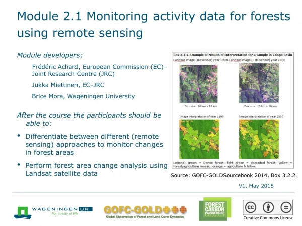
Module 2.1 Monitoring activity data for forests using remote sensing. Module developers: Frédéric Achard, European Commission (EC) - Joint Research Centre (JRC) Jukka Miettinen, EC - JRC Brice Mora, Wageningen University

E N D
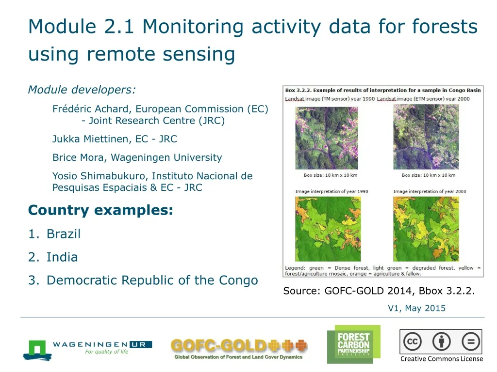
Module 2.1 Monitoring activity data for forests using remote sensing Module developers: Frédéric Achard, European Commission (EC) - Joint Research Centre (JRC) Jukka Miettinen, EC - JRC Brice Mora, Wageningen University Yosio Shimabukuro, Instituto Nacional de Pesquisas Espaciais & EC - JRC Country examples: • Brazil • India • Democratic Republic of the Congo Source: GOFC-GOLD 2014, Bbox 3.2.2. V1, May 2015 Creative Commons License
Country examples • The following slides will illustrate the main points of three different country-level approaches for forest-cover monitoring. • More details can be found in the Sourcebook (GOFC-GOLD 2014), section 3.2. • The country examples highlighted here include: • Brazil—PRODES deforestation monitoring program • India—Forest Survey of India (FSI) • Democratic Republic of the Congo (DRC)—JRC-FAO systematic sampling
1. Brazil: PRODES monitoring program • The Brazilian National Institute for Space Research (INPE) assesses forest cover annually over the entire Brazilian Amazon (~5 million km2) in the PRODES monitoring program. • The first assessment was undertaken in 1978, and annual assessments have been conducted since 1988. • Landsat, DMC, and CBERS satellite data (20-30 meter resolution) acquired around August every year are used. • Open source software TerrAmazon by INPE is used for preprocessing and assimilation of remotely sensed data. • The mapping is performed by visual interpretation and manual digitization of deforested areas (MMU 6.25 hectares). • Spatially explicit results are published yearly around December and are available at http://www.obt.inpe.br/prodes.
Brazil: PRODES yearly deforestation mapping (~3,400 km x 2,200 km) Green – Forest Violet – non-forest Yellow-Orange-Red – deforestation from 1997-2006 Landsat satellite mosaic of year 2006 and deforestation map period 1997–2006 of the entire Amazon in Brazil Source: INPE, PRODES project, http://www.obt.inpe.br/prodes/.
2. India: Forest Survey of India (FSI) • Remote sensing has been used in the biennial FSI since the early 1980s. • Currently, a 23.5 meter resolution IRS P6 satellite is used, with data acquired in October–December (to enable deciduous forest discrimination); minimum mapping unit is 1 hectare. • Unsupervised clustering followed by visual on-screen class assignment is used to produce the initial results. • Extensive six-month ground verification follows; necessary corrections (e.g., canopy density) are incorporated. • Extensive accuracy assessment using field plots and 6 meter resolution images (nearly 6,000 plots) is finally conducted. • The entire assessment cycle takes almost two years.
India: Forest cover map (1/2) Forest cover map of India, 2013 Legend Very dense forest Mod dense forest Open forest Scrub Source: Forest Survey of India website http://www.fsi.org.in/.
India: Forest cover map (2/2) A detail of the forest cover map of India Legend Very dense forest Mod dense forest Open forest Scrub Non-forest Source: Forest Survey of India website, http://www.fsi.org.in/
3. Democratic Republic of the Congo: JRC-FAO systematic sampling • A systematic sampling approach with 267 (20 × 20 km2) sampling sites distributed at every 0.5° was used. • 30 meter resolution Landsat data for 1990, 2000, and 2005 was obtained for all sampling sites. • The satellite imagery was analyzed with an object-based (multidate segmentation) approach using land-cover signature database and subsequent visual validation. • The results are represented by a change matrix for every sample site and allow derivation of nationwide deforestation rate at high statistical accuracy (e.g., 2000–2005 annual deforestation rate 0.32% ± 0.05%).
Defining degraded forest • Example of results of interpretation for a sample in Congo Basin • Source: Sourcebook (GOFC-GOLD 2014), box 3.2.2.
Democratic Republic of the Congo: Deforestation results DRC Source: Mayauxet al. 2013.
Recommended modules as follow-up • Module 2.2 to proceed with monitoring activity data for forests remaining forests (including forest degradation) • Module 2.8 for overview and status of evolving technologies, including, e.g., radar data • Module 3 to learn more about REDD+ assessment and reporting
References • Achard, F., Beuchle, R., Mayaux, P., Stibig, H.-J., Bodart, C., Brink, A., Carboni, S., Desclée. B., Donnay, F., Eva, H.D., Lupi, A., Raši, R., Seliger, R. and Simonetti, D., 2014. “Determination of Tropical Deforestation Rates and Related Carbon Losses from 1990 to 2010.” Global Change Biology 20: 2540–2554. • de Wasseige, C., P. de Marcken, N. Bayol, F. Hiol, Ph. Mayaux, B. Desclée, R. Nasi, A. Billand, P. Defourny, and R. Eba’aAtyi, eds. 2012. The Forests of the Congo Basin: State of the Forest 2010. Luxembourg: Publication Office of the European Commission. https://ec.europa.eu/jrc/sites/default/files/lbna25161enc_002.pdf • Ernst, C., A. Verhegghen, P. Mayaux, M. Hansen, and P. Defourny .2012. Central Africa Forest Cover and Forest Cover Change Mapping. In de Wasseige et al., eds., The Forests of the Congo Basin: State of the Forest 2010, 23–41. • Eva, H., Carboni, S., Achard, F., Stach, N., Durieux, L., Faure, J-F. and Mollicone, D., 2010. “Monitoring Forest Areas from Continental to Territorial Levels Using a Sample of Medium Spatial Resolution Satellite Imagery.” ISPRS J. Photogram. Remote Sensing, 65: 191–197. • FSI (Forestry Survey of India). 2013. State of Forest Report 2013. Dehradun, India: Forest Survey of India. http://fsi.nic.in/cover_2013/message_content_preface3.pdf.
GOFC-GOLD (Global Observation of Forest Cover and Land Dynamics). 2014. A Sourcebook of Methods and Procedures for Monitoring and Reporting Anthropogenic Greenhouse Gas Emissions and Removals Associated with Deforestation, Gains and Losses of Carbon Stocks in Forests Remaining Forests, and Forestation. (Often GOFC-GOLD Sourcebook.) Netherland: GOFC-GOLD Land Cover Project Office, Wageningen University. http://www.gofcgold.wur.nl/redd/index.php. • Government of Brazil. 2014. Brazil’s Submission of a Forest Reference Emission Level for Deforestation in the Amazonia Biome for Results-based Payments for REDD+ under the UNFCCC. Brasília. http://unfccc.int/methods/redd/items/8414.php. • INPE (National Institute for Space Research). 2008. Monitoramento da coberturaflorestal da Amazônia porsatélites: Sistemas PRODES, DETER, DEGRAD e QUEIMADAS 2007–2008. Brasília. http://www.obt.inpe.br/prodes/index.html. • Mayaux, P., Pekel, J-F., Desclée, B., Donnay, F., Lupi, A., Achard, F., Clerici, M., Bodart, C., Brink, A., Nasi, R., and Belward, A., 2013. “State and Evolution of the African Rainforests between 1990 and 2010.” Philosophical Transactions of the Royal Society B 368 (1625): 20120300. http://dx.doi.org/10.1098/rstb.2012.0300. • Potapov, P. V., S. A. Turubanova, M.C. Hansen, B. Adusei, M. Broich, A. Altstatt, L. Mane, C. O. Justice. 2012. “Quantifying Forest Cover Loss in Democratic Republic of the Congo, 2000–2010, with Landsat ETM+ Data.” Remote Sensing of Environment 122: 106–116.
Shimabukuro, Y. E., J. R. dos Santos, A. R. Formaggio, V. Duarte, B. F. T. Rudorff. 2012. “The Brazilian Amazon Monitoring Program.” In Global Forest Monitoring from Earth Observation, edited by F. Achard and M. C. Hansen, 167–184. Boca Raton, FL: CRC Press.