Download
1 / 37
370 likes | 380 Views
Advancement of an Enterprise Coastal GIS. Kathy Fitzpatrick, P.E., Martin County, Florida Echo Gates, P.E., Florida Department of Environmental Protection Robert Hudson, AICP, Photo Science, Inc. Heather Mounts, Photo Science, Inc. Martin County, Florida. Southeast Coast of Florida

E N D
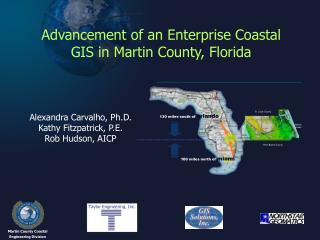
Advancement of an Enterprise Coastal GIS Kathy Fitzpatrick, P.E., Martin County, Florida Echo Gates, P.E., Florida Department of Environmental Protection Robert Hudson, AICP, Photo Science, Inc. Heather Mounts, Photo Science, Inc.
Martin County, Florida • Southeast Coast of Florida • “Sailfish Capital of the World” • Hit by 2 Hurricanes in 2004
Martin County Coastal Management Program • Artificial Reef Construction and Management • Habitat Management • Beach Maintenance • Inlet Maintenance and Management
Coastal GIS Strategic ImplementationPlan • Phase I: Scoping Exercise (2003) • Phase II: Assessment & Refinement (2004) • Phase III: Prototype Implementation (Spring 2005) • Phase IV: Migrate to Production System (Summer/Fall 2005) • Phase V: Maintenance & Enhancements (2006)
Coastal Program Business Objectives • Manage Martin County’s habitat, beach, inlet, and artificial reef resources through the effective implementation of engineering and restoration projects. • Monitor and analyze the effectiveness of the Coastal Program’s engineering and restoration projects. • Track permit requirements and automate the required permit submittals. • Properly distribute, track, and manage the Coastal Program budget and grant funding. • Collaborate with, and disseminate information to, federal and state agencies and the public.
Nearterm Activities • Finalize geodatabase design • Populate geodatabase with additional data • Deploy in Martin County’s production environment • Build tools and portals into the geodatabase
“Take Away” Points from this Presentation • Programmatic requirements and operational needs should drive the system design • Inventory the availability, type, and format of your data (not just spatial data!) prior to building the database • Use the available data models as a guide, not as a solution • Implement using a Phased approach that couples the availability of funding with a prioritized list of functionality of the system